Outlook:
As an upper level ridge continues to progress eastward over the Mid Atlantic, a surface high pressure cell will expand through the next few days, yielding nothing short of spectacular weather (at least through Tuesday evening).
Today: Temperatures soar into the upper 60s/low 70s under sunny skies and light winds. By nightfall as the trick-or-treaters make their ways into the streets, temperatures will have fallen off only into the lower 50s.
Tomorrow: The high pressure ridge that has been delivering this pristine fall weather will begin to degrade as it is forced off the east coast by an approaching trough. As anticipated, this trough, accompanied by a weak cold front, should roll through the region late Tuesday/early Wednesday morning. Tuesday will remain dry, but expect an increasing in cloud cover through the afternoon. Highs will still manage to make it into the upper 60s/near 70.
Wednesday: As a surface cold front rolls through the Mid Atlantic, winds switch to a more northerly direction, ushering in slightly cooler temperatures into the region.
Mother Nature's Timer is a bit off:
On October 29, the mountain ranges of Vermont received nearly 25-30 inches of snow as separate storm systems dumped the white stuff all over the northeast. The following Pictures were posted on Eastern US weather Forums yesterday. The photos are from the Killington, Vermont Ski area, and I must say--I'm just a bit jealous.
| Days | Mon | Tue | Wed | Thu | Fri | Sat | Sun |
|---|---|---|---|---|---|---|---|
| Lee C. | -- | -- | -- | -- | -- | -- | -- |
| John Y. | -- | -- | -- | -- | -- | -- | -- |
| Days | Mon | Tue | Wed | Thu | Fri | Sat | Sun |
|---|---|---|---|---|---|---|---|
| Temps | -- | -- | -- | -- | -- | -- | -- |
Mother Nature Cooperates for Halloween
First real Freeze possible tonight
FREEZE WARNINGS ARE IN EFFECT FOR AREAS NORTH OF DC TONIGHT, AND FROST ADVISORIES TO THE SOUTH.
Today, temperatures will once again be hard pressed to make their way out of the mid 50s, although the stellar sunshine may make up for the chilly conditions. Just make sure to bundle up before heading outside, particularly this morning with temperatures in the 40s.
Tonight, temperatures dip into the low 30s under clear skies--and for this reason--freeze warnings have been hoisted for areas north of DC.
Tomorrow, the upper level trough that has been the culprit behind the below average temperatures will erode as it moves northeast, and finally allows a mid level ridge to make its presence felt. This will allow warmer air to be transported into the region, so expect highs tomorrow in the mid to possibly upper 60s, depending on where you are.
As we work our way into Tuesday and Wednesday, high temperatures hover around 70 under the same old brilliant sunshine. Even though model discrepancy becomes more pronounced (as is often the case at 100 hours), a general consensus of dry, near average weather prevails. High temperatures over the week don't really move much from the upper 60s.
'The Perfect Storm'
Many New Englanders probably remember the now infamous storm of 1991 that has become the topic of Sebastian Jungers best selling story, and Wolfgang Peterson's movie, which debuted in 2000. Coined by a NOAA meteorologist-Bob Case- the Perfect Storm was a weather system of unimaginable proportions enveloped practically the entire Eastern Seaboard in rain and high winds for days, and rode men fishing near the Flemish Cap to their watery graves--and gave the crew of the Andrea Gail a place in history.
On this date, 14 years ago, the remnants of hurricane Grace became enveloped in a developing extra-tropical low pressure system moving off the East Coast. The low, aided by significant upper level wind support, deepened rapidly over the western Atlantic waters. Wind gusts to hurricane strength were recorded in eastern Mass, and several fishing vessels south of Nova Scotia recorded wind gusts above 100mph.
Above: Weakening Halloween Storm on October 31, 1991
The Perfect Storm was a combination of several factors coming together a just the right time to form a weather system on incredible proportions--Hurricane wind gusts, 50-90 foot rogue waves, and driving rain. A once-in a-lifetime event, this storm is what weather legends are made of.
Fine weather marching into the Weekend
A FROST ADVISORY IS AGAIN IN EFFECT FOR THE ENTIRE METRO REGION AS TEMPERATURES ARE EXPECTED TO FALL INTO THE LOW-MID 30S TONIGHT.
Outlook:
The forecast remains fairly simplistic through the next 3-4 days as strong surface high pressure begins to squeeze its way into the region from the northwest. As the Hp cell continues to build east into the Mid Atlantic, a surface low just east of the NC/SC coast will be shoved far enough away from us to leave us with crisp, sunny, mid-autumn weather over the weekend.
As Sunday rolls around, the surface high and mid level ridge (kind of like a surface high pressure cell in the mid layers of the atmosphere ~20,000 feet) finally catches up to the region, inducing what is known in weather speak as "WAA." Otherwise known as Warm Air Advection, this phenomenan is simply the movement, or ADVECTION, of warmer air into a region. With this said, high temperatures Sunday should finally be able to make it into the upper 60s/near 70.
As we approach Wednesday, however, things get a little trickier. Over the past few days, a potent upper level low has moved east off the northeastern portion of Russia near the province of Magadan, and merged with an equally impressive Aleutian Low (given its name from the predominate location near the Aleutian Islands). Since then, the low has carved out a trough in the northwestern part of the Contiguous United States. By Wednesday, the remnants of this trough are expected to have moved across the extreme northern US-entering our territory on the East Coast.
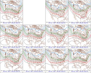 Models--like the GFS in particular--have had a very rough time forecasting the movements of this trough-ridge-trough pattern that has set up across the United States. For those 'weather fanatics' out there, the image to the right is a plot of several GFS ensemble members valid at 120 hours from 12z this morning (Wednesday morning). Several of them develop a decent trough over the east coast, and at least two of the ensemble members develop a negative tilt of the trough axis (ie: a tilt from the southeast to northwest), which would in turn allow for increased chances of some type of coastal low developing and affecting our region. A less potent trough, on the other hand, would keep precip chances to a minimum-and allow temperatures to remain slight higher than average through the week.
Right now, I like the latter solution given most models support this, and the models that do develop a weaker trough analyzed that trough out west much better.
Image above right: Ensemble members of the Operational GFS from PSU E-Wall
Beautiful Fall Colors:
Okay, since the trees here really aren't changing all that quickly in color, I thought we could use a picture of some truly magnificent fall foliage.
I came across this fantastic and breath-taking image of a forest of fire-red trees at the San Vicino Mountain, taken by Francesco in central Italy. This snapshot reminded me of just how serene and placid late autumn can be-not just in Italy-but here in the Nation's Capital as well.
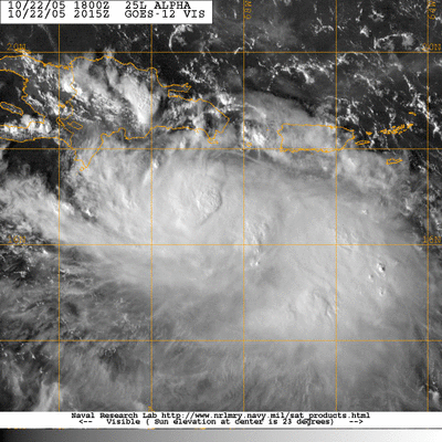
Tropical Storm Beta is still spinning around in the Caribbean near Nicaragua, where it is expected to make landfall sometime Sunday as a hurricane, possibly eclising the 100mph mark.
Other than Beta, the rest of the Atlantic remains relatively quick, save the normal patchy thunderstorm clusters/tropical waves, although none of these show signs of imminent development.
Cold weather on tap Tonight
A FROST ADVISORY IS IN EFFECT FOR AREAS WEST OF THE DISTRICT IN RESPONSE TO EXPECTED LOW TEMPERATURES DIPPING INTO THE LOW-MID 30S.

Scattered clouds, low sun-angle, and stiff northwesterly winds all combined to produce a chilly autumn afternoon in the Nation's Capital region. High temperatures today were generally kept in the mid 50s-and these below average temperatures combined with occasional wind gusts to 30 mph made for one of those days where you just want to bundle up or stay indoors.
Tonight, we have the chance of seeing the first frost of the season (which would effectively end the growing season for locations that do develop a frost). Mostly clear to partly cloudy conditions, along with light winds and a dry surface layer, temperatures will fall quickly off towards the dewpoint value in the lower 40s. The best chance for frost will, however, be confined to areas north and west of the immediate metro region.
The coldest part of the day is normally just before sunrise, and we expect temperatures at that time to range from the mid-upper 30s in town, to near 30 out in the western 'burbs. Any plants you have left outside that are susceptible to dying when introduced to sub 32 temps should be brought inside tonight.
Temperatures try to warm back into the mid 50s tomorrow under partly cloudy conditions.
Image above right: Light blue are frost advisories, cyan color are freeze warnings. Image courtesy of Theweathercenter.com
Extended Outlook:
High temperatures begin to moderate somewhat over the weekend as high pressure noses into the region. Highs next Sunday may approach 60F, and possibly make it to near 70 by Monday. Other than this, nothing of any significant importance develops during the time frame from this Friday until next week.
Tropical Talk:
Just when it seems the tropics cannot possibly get any more active, two separate entities in the tropical Atlantic basin bear monitoring for development over the next hours and days. The first is a relatively well defined cluster of thunderstorms and a low pressure center the Nicaragua/Costa Rica regions. Conditions appear to be relatively favorable for continued development over the next few days as it drifts slowly north (although the exact motion is quite hard to piece out at the moment).
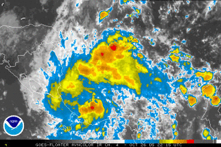 The second area of disturbed weather is located around the Lesser Antilles. Although upper level conditions are not particularly favorable for any significant development, conditions may become a bit more conducive for development over the next several days.
The next storm name on our 'list' is Beta.
Winter storm out west:
Yesterday, nearly 1 foot of snow fell in Garret County, and upwards of 4-6 inches in isolated locations of central PA.

A dry September; Record Wet October
Clouds are rapidly dissipating across the region as moisture rockets towards the northeast. Expect mainly sunny to partly cloudy conditions today--and make sure to bundle up as high temperatures will be hard pressed to make it into the mid 50s in the District.
Winds will also make it feel like late Autumn as they gusts to 20-30mph; however they will not entirely associated with the departing Nor'easter, rather, winds mixing down from a couple thousand feet up will add to the blustery conditions. The winds pick up after sunrise today.
DC's Record Rainfall:
Ever since the 6th of October, rain gauges across the region have begun recording precip totals to what has now become the wettest October in history for the DC metro region. From the 6th-8th, a strong low pressure system and stalled frontal boundaries dumped over 7 inches of rain at DC's Reagan National Airport. From the 11th to the 14th, several waves of low pressure skirted the region, delivering marginal precip totals near a quarter of an inch. And today, with a strengthening Nor'easter moving up the East Coast, Washington, DC eclipsed its previous rainfall record of 8.81 inches set back in 1937 at 1PM EDT. Since then, the rain gauge at Reagan National Airport has continued to fill, bringing the monthly total to a staggering 9.32 inches.
Likewise, BWI also reports rainfall totals now eclipsing 9.5 inches, shattering the old record of 8.41 inches set back in 1941.
It's absolutely incredible that last month it seemed like we couldn't buy a day of rainfall, with less than .11" falling in a period of 30 days-and now we have rainfall records the very next month. Still, October of 2005 cannot compare with the September of 1934 when over 17 inches of rain fell in that 30 day period.
Regional Outlook:
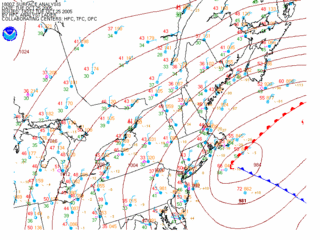
With respect to this latest rain event, I can safely say that Wilma was NOT the main weather player in this set-up. As indicated in the previous post, a low pressure/nor'easter-esque scenario developed as an upper low on the western flank of the Appalachians transferred energy to the east coast. The low now sits as it deepens/strengthens just south of Cape Cod. The Washington Post published an article on this storm this afternoon.
Tonight, the said low pressure system pulls northeast into the Grand Banks, leaving us with a cold, mostly cloudy day tomorrow. Given some residual low level moisture--at least in the lower levels--a small chance (30% or less) of showers will persist through at least the morning hours tomorrow, until the intense low pulls the remaining moisture out of the region.
At least through Friday, high temperatures will have a hard time making it into the upper 50s as northwesterly winds draw in cooler Canadian Air.
After Saturday, there is some light at the end of the tunnel as highs try to moderate into the upper 50s/60s as high pressure settles in overhead.
Wicked Early-Autumn Weather
 Make no doubt about it, Hurricane Wilma is the main weather feature of the day. Although weakening as she begins to take on extra-tropical characteristics (developing a cold-core center, and frontal structure), Wilma still packs a punch as a 115 mph Category 3 Hurricane. There has been some confusion as to whether or not Wilma is actually the cause of all this nasty weather. Looking over surface plots/computer models, it appears a separate entity is the culprit behind this raw day in the Nation's Capital.
An upper level low present on radar yesterday has become absorbed by the extreme western flank of Wilma's expanding width. The scenario with this storm system is incredible--up to 7 inches of snow has fallen in the higher elevations of the Appalachian Mountains of western PA, MD, and WV. Flood warnings are out on the east coast for rainfall totals in excess of 5 inches, and high wind warnings are up for the Northeast; as Wilma deepens, winds will crank out of the west in Massachusetts, possibly eclipsing hurricane strength of 75 mph. This, along with heavy rain and cold temperatures will make for an absolutely horrid day in New England.
 Hurricane Wilma loosing tropical characteristics in the western Atlantic. An upper low over the Appalachians is the culprit behind out nasty weatherWe in the Mid Atlantic have it off a bit better. Winds are only gusting to near 20-30 mph, and the rain showers are comparatively light. The graphic above right reveals the NAM's forecast precipitation from this morning to early this afternoon. Places light Manhattan, Poughkeepsie, NY are in for a drenching, with winds gusting to 50 mph.
So the breakdown for the region goes like this:
Wilma begins to lift out to the northeast into the Grand Banks area this afternoon, taking a lot of the precipitation with it. The upper low hanging out to the west will begin to transfer its energy to a developing coastal low, which will begin to lift out of the region tonight and tomorrow morning. While the chance for showers will decrease markedly overnight tonight/Wednesday AM, at least a chance for showers will hang around through Wednesday until the coastal low zips out towards Nova Scotia. As this happens, winds will decrease into the breezy range:10-25 mph Wednesday evening.
Crazy Weather Scenario Next 48 Hours
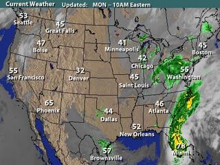 With Category 2 Hurricane Wilma roaring off the Florida coast later this morning, a set-up for a monster storm scenario will begin to unfold. The remnants of former Tropical storm Alpha have merged with the extensive moisture feed from Wilma, which is moving steadily up the east coast.
A separate low pressure system associated with a Midwestern Trough is spinning around just west of the Appalachian Mountains, spreading scattered showers into the region, especially north and west of the City.
As the day wears on, Wilma will continue to accelerate up the east coast, eventually merging with the said low in the Ohio River Valley. As this occurs, winds will steadily increase out of the west, then the northwest, as Wilma wraps up to a position about 100 miles or so east of the coast.
 With this set-up: Expect rain showers to increase in coverage through the day and tonight. Winds will become gusty out of the northwest as Wilma makes her closest approach to the region. Gusts to 40 or 50 mph are possible with this scenario, along with rainfall totals approaching 2 inches in some locations--mainly east of the District along coastal sections of the Mid Atlantic and Northeast states.
Due to the expected rainfall totals, NWS offices up and down the east coast have issued Flood Watches: from Delaware to New York in response to Wilma. And if you look closely, there is a Winter Storm Watch up for the North Country of New York States Tuesday evening and Wednesday as Wilma draws in cold Canadian air.
Wilma will eventually move out of the picture midweek, as she ushers in cooler air that has been building in southern Canada. It looks like winds will stay up in the 20mph range through Wednesday.
Wet and wild this week?
 Hurricane Wilma:
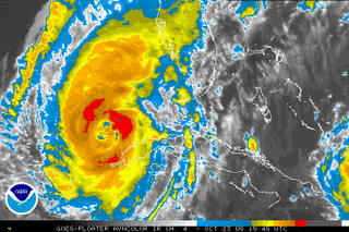
As of 2PM EDT, Wilma was still a category 2 hurricane with maximum sustained winds around 100mph. There have been a few indications that Wilma is trying to re-strengthen over the warm Gulf waters, such as a collapsing inner eye wall and expanding cold cloud tops, but surface winds have not really moved today. A Hurricane Hunter reconaissance aircraft is currently flying in and out of the storm, sending data via dropsonde samples back to the Hurricane HQ in Miami, Florida.
Wilma has begun to accelerate ahead of an approaching trough of low pressure in the mid levels centered through the nation's midsection. Given the present foreword movement and somewhat favorable conditions in the southern Gulf of Mexico, it appears Wilma will make landfall as a major category 3 storm somewhere between Naples, and Boca Grande, Florida bright and early Monday morning.
Wilma's repercussions this week:
As Tropical Storm Alpha continues to get chewed up by the mountainous terrain of Hispanola, Wilma will continue to trudge eastward into the ever popular state for landfall that is Florida. There is some increasing concern that Wilma throws some wet and windy weather our way as the new work week begins.
Tonight and tomorrow, a trough in the mid and upper levels of the atmosphere (basically a lowering of atmospheric height) cuts its way through Illinois and Ohio, gradually assuming a position just west of the Mid Atlantic region Monday evening. As this happens, what's left of Wilma and former TS Alpha merge off the east coast. Recent runs of the Global Forecast System Model (GFS), UKMET, ECMWF, and Canadian have unanimously re-introduced Wilma as a key player in our weather Monday night/Tuesday.
While there is still confusion as to how close Wilma makes it to the East Coast still exists, there is an increasing threat of some early-week rain/wind in Mid Atlantic and Northeast. Again, how much rainfall/wind we receive is directly related to how close Wilma makes it to the seaboard.
Here are a few quick scenarios with respect to the Monday/Tuesday timeframe:
[1] Most Likely: The closest approach Wilma makes on the region is about 100 miles offshore early Tuesday morning. If this scenario is correct, the most our region would see from the accelerating storm system would be gusty winds around 15-30mph, and rainfall totals averaging less than 1".
[2] In-between: Wilma's closest approach to the region is between 50 and 99 miles as it grazes the East Coast. This would result in winds approaching 30-45 mph in some gusts, and rainfall totals near 2-3 inches.
[3] Least likely: Wilma basically makes landfall along the Eastern Seaboard and rides northeast into the Canadian Maritimes. Wind gusts would approach 50 mph with rainfall totals ranging from 4-6 inches.
You ready for Alpha?
With Alpha, this is the single busiest Atlantic Hurricane Season on record with respect to tropical storms. The second busiest season was way back in 1933 with 21 named storms (they got through the W name). Without a doubt, this has been an absolutely incredible (and devastating) hurricane season.
Hurricane Wilma-'Devastaion':
Wilma is just about to emerge off the extreme northeastern portion of the Yucatan Peninsula, and re-introduce itself into the warm waters of the Gulf of Mexico. Wilma has not lost too much of its punch due to the fact that more than half of the storm remained over water for its duration over southeastern Mexico.
With unofficial reports of 5-6 feet of rain, and a long-duration high wind event (reports range from 100-145 mph) from the slow moving storm, I fear we will see some horrific pictures emerge from the Yucatan as things clear out.
As a benchmark, consider Hurricane Mitch as it wrecked whole communities and villages in Central America during 1998. Rainfall totals in the aforementioned regions approached 70 inches (5.8 feet) of rainfall in 24-48 hours. This caused catastrophic flooding of unimaginable proportions , destroying hundreds of thousands of homes and sweeping men, women, and children to their watery graves. This is the scene that will be unfolding in the near future as Wilma pulls away into the southern Gulf of Mexico.
 Cancun took a fierce battering as the center of the Category 3 storm passed directly over Cozumel Island before landing near Playa de Carmen, south of Cancun.
 The Weather Research Forecasting Model:
I am not completely sure about the accuracy of this computer model, but I stumbled across this today on EUSwx boards. This is a high-resolution computer model with somewhat of an outlier solution with regards to wind speed at landfall in western Florida. The said model brings Wilma onshore between Port Charlotte to Cape Coral very early Monday morning as a category 4/boarderline 5. Even though Sea surface temps are very conducive for strengthening, upper level winds will become increasingly unfavorable for significant development as Wilma emerges into the Gulf.
At this point, I think a category 4 storm impacting southwestern Florida is pretty much out of the question, but Mother Nature has been known to throw curve balls at forecasters every now and then. This is just something to keep our eyes on.
Weather breakdown over our region:
Scattered showers are visible on regional radars, and will continue through the night. Tomorrow, we will finally be able to the see the sun as low pressure lifts out of the region to the northeast.
Dreary weather in the offings
Cloudy conditions and occasional drizzle/light showers will be the rule tonight. Dreary weather will continue through Saturday.
Tomorrow, a surface low feature that moved out of the eastern Rockies will approach the region from the west, keeping the chance of scattered rain showers in the forecast through the weekend. Rainfall will likely be the heaviest during Sunday, as the low pressure center makes its closest approach on the region.
The NAM, although notorious for over-forecasting rainfall totals, pumps out in excess of 1" of precipitation through Sunday afternoon.
Wilma Forecast:
Major Hurricane Wilma continues to churn up the waters in the extreme western Caribbean Sea as a powerful Category 4 system with surface winds estimated near 150 mph. Wilma has a few more hours over the warm waters of the Caribbean before it moves close to the extreme northeastern portion of the Yucatan Peninsula tomorrow afternoon.
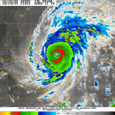
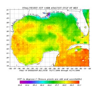 The Infra-Red satellite image above reveals a large, annular eye attempting to develop right underneath the most powerful convection (otherwise known as the Central Dense Overcast). Oceanic heat content remains very high up until landfall, with sea surface temperature maps revealing a plume of 83*F+ temperatures in no short supply anywhere in the Gulf of Mexico/Caribbean Sea.
One possible problem in the short term with regards to this systems intensity is its current movement. Recently, the center jogged slightly closer to a 360 degree movement (due north). This sudden shift in foreword motion is likely due to a developing mid-latitude trough deepening in the central United States (the same weather feature that will be brining our region the continued chance for rain through the weekend).
Latest NHC advisory maps brought Wilma onshore very near the Playa del Carmen, just southwest of Cancun. However, due to the developing trough to the storms north in the central United States, a more northward track is anticipated, a Wilma will likely graze the easternmost portions of the Yucatan--but should not actually make landfall in the said area. However, it must be stressed that even with a track a bit farther east, this system will doubtlessly cause catastrophic damage to portions of the Yucatan over the next 36-48 hours.
Possible effects from Wilma later next week:
There is still a large amount of model spread with regards to the impacts (if any) Wilma has on the region's weather next week. The wildly oscillating GFS now seems to be emphatic on keeping Wilma far enough away from the coast to prevent the region from seeing much more than some breezy weather, and some spotty showers next week. The model keeps whisks Wilma out to sea as a powerful trough digs into the eastern US early next week. This trough acts like a brick wall, and keeps any low pressure system to the east from moving west into the Mid Atlantic.
However, there are still models that show a partial phase of this monster hurricane next Monday/Tuesday, and this scenario cannot be ruled out. Such a forecast would bring Wilma closer to the coast, yielding more rainfall, and gusty winds from the powerful low.
Nasa's Hurricane Animation:
And while on the topic of tropical weather, NASA has published an animation of all the tropical systems in the Atlantic starting on June 1st, 2005. ***Warning*** This is a large 20MB file that took about 30 seconds to download on my high speed connection. Dial-up users could experience long download times.
All good things must end
This is pretty much the last full day of "nice" weather around the region for awhile. Tomorrow, clouds thicken in response to an advancing cold front that will move through the region late tonight/early tomorrow morning.
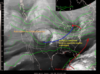 Due to increasing cloud cover and winds shifting around to the north, high temperatures will likely be held at bay in the mid 60s.
All indications point to a pretty much dry frontal passage (aka FROPA in weather jargon), however, an isolated shower cannot be ruled out Thursday afternoon.
Clouds will hang around into Friday. At the same time, a ripple in the atmosphere in the form of an upper level trough will slide east from the Rocky mountains, and will likely spread some light rain showers over the Mid Atlantic states Friday afternoon. After this, the forecast becomes quite tricky...
Extended Outlook:
Early Saturday morning, in the south central provinces of Canada, an upper level low will be developing--rather harmlessly as it slowly progresses southeastward into the Contiguous United States. By Sunday morning, this upper low has made its way into the Ohio River Valley, south of Lake Michigan.
The low discussed earlier that had moved in from the west on Friday will still be spinning around in the New England region. As the upper low approaches from the west, the surface low phases with it, forming a large and complex area of disturbed weather over the Great Lakes region, possibly inducing the years first lake effect rain/snow showers. The presence of this strong duo-of low pressure systems will keep the chance of showers in the region all the way into next week, when yet another factor comes into play..
Hurricane Wilma...which was the strongest hurricane ever recorded in Atlantic Basin history with a minimum central pressure of 882mb this morning, will continue its slow journey through the western Caribbean over the next two days. By Saturday evening, she will likely be traversing the state of Florida as a major hurricane. At the same time, a complex set of procedures will be taking place in the atmosphere.

..Wilma will begin to phase with the previously mentioned low pressure system complex in the Northeast. There are significant timing differences as to when Wilma begins to phase with the upper low, and differences in location--the GFS being a prime example. Every few runs it oscillates back between a full phase (bringing the storm almost right up the east coast), and a semi-phase, where Wilma remains well offshore, with minimal effects on the region.
At this point, it appears we will feel the effects from Wilma (who still may, key word is may, still be a hurricane as it passes our latitude). As to the magnitude and potency of the system--details have yet to be worked out. Until models can cluster in a reasonably uniform manner, we're basically forecasting blind (although we're not that bad off).
The progression of these weather systems will be watched carefully over the next several days. At this point, I have a moderate amount of confidence in saying the area has the potential to receive anywhere from 2-5 inches of rainfall, depending on the position Wilma decides to take, be it a phase, semi-phase (aka Linkage) or drifting out to sea.
Wilma Spinning in the Caribbean
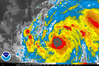 UPDATE:
The image at right is the IR image from 8:15 PM EDT. Notice the extremely cold cloud top temperatures around the center of the storm...close to -80C (you probably wouldn't want to be out in temperatures that cold, that's about -115*F). Also, draw your attention to that little hole in the center of the coldest cloud tops--that's the hurricanes eye starting to develop.
Continued strengthening is anticipated through the day tomorrow.
Next Few Days:
We get treated to another spectacular day as temperatures crawl into the mid 70s under mainly sunny skies. There is again a hint of downsloping and compressional heating as air rises over the peaks of the Appalachian mountains, and then descends into the Shenandoah Valley. The air warms as it looses altitude, spreading the absolutely perfect highs into the region.
On Wednesday, winds become more southerly, again pumping in high temperatures into the mid/upper 70s.
A Cold front moves through the region Thursday morning. Clouds and a northwesterly wind will likely keep high temperatures down in the mid 60s. At this point, precipitation chances are quite low--generally less than 30% through the day Thursday, but we can't rule out the chance that you run into a stray shower. The front then clears the region Thursday afternoon, drawing in cooler air for Friday. We'll still likely be under the influence of a moist flow off the ocean, so expect mostly cloudy conditions through Friday morning and afternoon.
Talkin' about the Tropics:
Tropical Storm Wilma has gained some steam, and maximum sustained winds are now near 70 mph--and Wilma is expected to become a hurricane Later today or tonight.
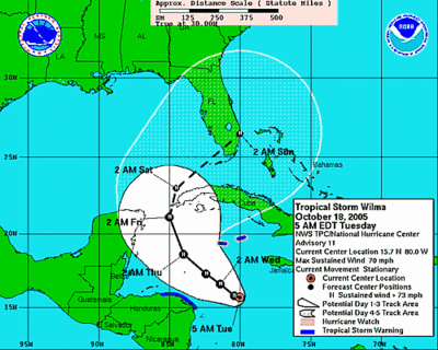 The movement of Wilma, at least in the next 4-5 days is relatively certain. A northwestward drift towards the eastern Yucatan Peninsula, and then a sharp turn to the northeast towards the southern tip of Florida Sunday.
The problems arise after day 5, when models diverge on possible scenarios.
Over the weekend, the GFS develops a very deep upper level low pressure system in the Midwest, which attempts to "phase" with the approach of Wilma, but fails to completely do so, resulting in what forecasters call a "linkage".
This scenario would result in moderate rainfall for the region, and gusty winds from 15-30 mph.
Another Scenario, although less likely, still remains possible--Wilma misses the upper low to the west, and continues its treck out to sea, with minimal effects on the region.
A final solution is a full phase of Wilma, meaning the low gets completely absorbed into the upper low in the Midwest/Ohio River Valley area. This would result in catastrophic flooding for the already rain-soaked Mid Atlantic and Northeast, and the wind associated with the storm would further jeopardize the weakened roots of the trees.
The GFS, on its current run, develops about 1-5 inches of rainfall across the entire Mid Atlantic/Northeast regions. We will continue to monitor the forecasts over the week--and my current thinking is a semi-phase/linkage will occur, which would result in a moderate to heavy rainfall event for the region early next week.
The crisp feel of Autumn's in the Air
Next several Days:
Generally speaking, tomorrow will feature much of the same type of weather that we saw today, although winds will have calmed, and highs will be about 5-10 degrees warmer, as high pressure begins to nose into the region.
There is a bit of a hiccup we have to avoid Thursday morning, in the form of a very weak cold front that will try to slip into the region from a rather odd direction--the northwest. Most models develop either very little precipitation (<.1") or no precip at all with this frontal passage. At this point, it appears you have a better chance of staying high and dry than seeing substantial precip. A cold front, does however, look like it will roll through the region late Wednesday night/Thursday morning, pushing high temperatures back down into the upper 60s/lower 70s for Friday and Saturday. Then the forecast gets absolutely chaotic... Clouds will likely thicken Friday night and Saturday--but not due to Wilma--rather, a developing low pressure system moving in from the west, and with the approach of this low, showers become a possibility over the weekend.
Confused Models, confused forecasts
With respect to Tropical Storm Wilma (yes it did become the 21st named storm of the Atlantic Hurricane season, which ties this season with 1933 for the most named storms in one year), this is an incredible amount of model discontinuity from run to run. A few runs ago, the GFS rammed Wilma into western Florida, however the model now runs Wilma through the Florida Keys and up the east coast next Monday.
At this point, a generally west-northwestward track should continue, until Wilma reaches the eastern tip of the Yucatan, when a quick turn to the northeast is anticipated. How far east the storm heads is dependant on upper level synoptics. Florida looks like a good target at this point, and interests in the eastern Gulf of Mexico should monitor Wilma's movements closely over the next few days.
After this, it seems likely Wilma get pulled up in a northeasterly fashion up the east coast, again, how far east remains heavily dependant on the strength of a trough to the north.
There is too much data that still needs to be sorted through to make any accurate stab a this forecast regarding Wilma's effects (if any) on the region.
Awesome early-autumn weather
A FROST ADVISORY IS IN EFFECT FOR SOUTHERN WEST VIRGINIA TONIGHT.
Weather recap:The highest wind speeds I could find were from our home Reagan National Airport wth the highest sustained wind peaking at 28 mph, and the highest gust at 37 mph.
Weather over the next few days:
Bundle up the next few mornings as you head out the door. Clear skies, calming winds, and low dewpoints will favor temperatures dipping into the lower 40s in the DC 'burbs
Tomorrow, winds slacken as low pressure pulls away to the northeast over the Canadian Maritimes. At the same time, weak high pressure attemps to push northeastward into the region from the southwest, effectively washing out any leftover moisture in the atmosphere, yielding a gorgeous early-autumn afternoon. Highs tomorrow will again struggle to make it out of the 60s (I'm going with a high of 69*F for DC).
Temperatures begin to moderate somewhat Tuesday through Thursday as high pressure encroaches on the region. We may once again approach 80 for highs by Thursday.
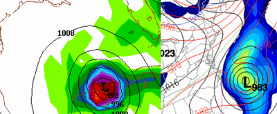 Some confused computer models
After Thursday, the forecast becomes a bit more tricky. The GEM computer model, run by the Canadian Environment Center, remains emphatic on drawing an intense low pressure system (soon-to-be Wilma) up the east coast, to a location just about 100 miles east of Charleston, SC Thursday night. The GFS paints a completely different story, drawing TD-24 between the Yucatan Pennisula and the western tip of Cuba valid the same time.
The GFS later slams this storm (a hurricane most likely) into the western Florida panhanlde Sunday morning. Another solution comes from the ECMWF (The European Center for Medium-Range Weather Forecasting), which seems to split the two model forecasts. The Euro moves this storm to a landfall location a bit farther south to near the Punta Gorda, FL area Sunday morning, then traverses the low across the state, emerging it back into the atlantic.
Some changes in store next week?
Talkin' Tropics:
Tropical Depression 24 developed earlier today in the western Caribbean with maximum sustained winds around 30 mph. The depression continues to become better organized, and will likely become Tropical Storm Wilma early tomorrow. There is some uncertainty as to where TD-24 heads given its slow foreword progression. Most models keep the depression nearly stationary/slight westward drift over the next 2-3 days, and then begin to accelerate it up to the northwest, and then north over the western tip of Cuba.
 The European Model (ECMWF) seems to have a relatively good handle on this system, which eventually draws it northward into eastern Florida Saturday morning. The more bullish GFDL model takes TD-24 on a similar track, but intensifies it to a catastrophic category 5 hurricane over the extreme western Caribbean in a little under 5 days. This seemed a little over the top, and subsequent runs of the said model have backed down slightly on forecast intensity.
Other models, such as the Canadian and GFS, develop the system much quicker than the ECMWF, and have the system sitting due east of Newfoundland the same time the Euro has the storm off Florida. The National Hurricane Center seems to be following the ECMWF and other operational hurricane models to forecast this systems movement.
Going back to the Canadian's analysis of this situation; if one were to follow this model (which, at least in my opinion is a strong model to add to the forecasting arsenal) we would have a very powerful hurricane sitting off the outerbanks of NC Thursday afternoon.
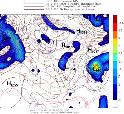
At this point in time, there are far too many variables that have the potential to change significantly over the next several days to make a confident prediction regarding TD-24's movements. However, it is in the best interest of anyone living in the western Caribbean, including western Cuba and Central America to keep a very close eye on this system. It is forecast to become a hurricane, and possibly a severe one with winds in excess of 110 mph. Florida is the target at this time, but details will be worked out over the coming days.
Given the presence of a powerful low pressure system somewhere along the Eastern Seaboard, there may be some repercussions around the Mid Atlantic and Northeast in the coming weeks. A majority of the mid and long range models develop a powerful early-autumn trough of low pressure around the Great Lakes region in the next 7-10 days. The set up here would favor the first snowfall in the northeast, and very cold temperatures in the Mid Atlantic.
Granted, the time frame for the forecast here is wicked...nearly 200 hours out, but this is something to watch in the coming days.
What's that...Is it the Sun?
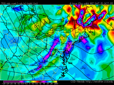
Temperatures tomorrow should be a tad cooler due to a lesser amount of something called downsloping. This phenomenon occurs when air traverses mountain chains (in this case the Appalachian Mountains), usually at a right angle, which is what is occuring today. The effects of downsloping winds are very simple: increased temperatures, lower humidity, and a stable environment. Forecasters often look at the 700mb progs (weather forecasts for the level around 9000 feet or so, however this can change dramatically with nearby lows/highs) to determine where strong downsloping winds may occur.
Take today's six hour forecast valid this afternoon from the North American Mesoscale Model run by the NCEP (National Center for Environmental Protection). This map shows areas of positive or negative vorticity (basically just "spin" in the atmosphere). Notice the dark purples on the western flank of the Appalachian Mountains--that's negative vorticity, a great indicator of a downsloping wind effect on the region.
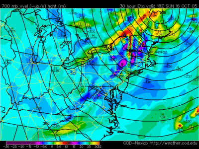
 Now check out the prog for the afternoon on Sunday. There is significantly less pronounced negative vorticity west of the Appalachians, hence, the downsloping component should be minimal. So, temperatures will not be moderated as much yielding the cooler high temperatures in the upper 60s to near 70.
Tropical Weather:
A
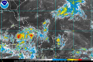 n aircraft reconaissance mission into an area of disturbed weather in the western Caribbean is scheduled for this afternoon. The area of convection near Jamaica has continued to organize, and looks like a tropical depression at the moment. My guess is the Hurricane Center upgrades this system this afternoon in its 5:00 update.
Sea surface temperatures in the western Caribbean are extraordinarly high, with isolated readings around 32C (90F).
The overall movement of this system is uncertain, and computer models are spread over a wide area, confused as to where this system goes after today. Once the recon aircraft gets into the system and can report some observations back, models will have more data to ingest to help forecast this systems movement. Interests near the Yucatan, and around the entire western Caribbean should monitor the progression of this system closely.
(And if this does make it Tropical storm strength, it would be named Wilma).
Better outlook heading into the Weekend
Last Update on Oct 14, 3:53 pm EDT
| Partly Cloudy 70F (21C) |
|
Also notice the wind speeds: sustained out of the north at 12 with gusts approaching 20 mph. As a low pressure system to the east begins to strengthen and head up towards Nova Scotia, a relatively tight pressure gradient will develop. Expect breezy conditions tomorrow, with winds sustained around 10-20 mph with some higher gusts--and these will gradually subside Saturday evening as the low pulls away into the Canadian Maritimes, and high pressure approaches from the west.
Weeked Outlook:
With all of the dismal weather over the past week, we deserve a weekend with a little sunshine. Saturday looks spectacular, with highs topping out in the mid to upper 70s and decreasing cloud cover.
Sunday is even nicer as winds subside below 10mph, and high temperatures look to be about 10 degress cooler--generally staying upper 60s to near 70.
Extended Outlook:
There is some model discontinuity in the extended range, particularly between the one of the premier forecast models (GFS) and GEM (Canadian Model), and the usually very accurate ECMWF. Tuesday afternoon the GFS drills a small area of low pressure southeastward into the Mid Atlantic from southern Canada. This model has not been extraordinarily consistent over the past few runs, so confidence in this particular forecast is a bit lower. The GEM says "what low?" keeping the region dry until next weekend.
The ECMWF does develop a weak low pressure system in southern Canada, but scoots it mainly eastward with minimal affects on the region. Best bet right now is to expect a few more clouds Wednesday and Wednesday night, but precipitation chances are very low at this point.
Tropical Beat:
The National Hurricane Center is keeping an eye on an area of disturbed weather near Jamaica, which has shown signs of organization over the past several hours. Conditions look ripe for another tropical entity to develop in the coming days, and this may ultimately become a western Caribbean threat later next week.
Fine weather on the horizon
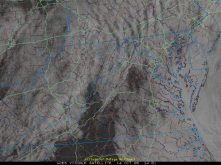 It's the same story again today, low clouds and occasional showers/drizzle. However, there is some good news--regional visible satellite images show some breaks in the cloud deck over northern VA and along the eastern slopes of the Appalachian Mountains.
Chances of precipitation rapidly decrease tonight as a trough scoops the low clouds out of the region, and we're basically left with a partly sunny day Saturday. As low pressure strengthens off the east coast Saturday night, winds will turn to the northwest and increase to 10-25 mph.
High pressure finally builds in Monday morning, the winds will slacken, and the weather will return to a more settled pattern with fewer clouds and moderating temperatures.
The Weekend Forecast:
With regards to Saturday's high temperature, models do ushering in quite chilly Canadian air, at least in the upper levels over the region. A factor known as compressional heating and downslope airmass modification will be a factor in high temperatures over the weekend. With winds turned around the to the west/northwest, cool air will likely be banked up on the west sides of the mountains, while air riding over the high peaks warm as they slide down the slopes into the Shenandoah Valley, DC area. I was thinking highs Saturday would be near 60-65ish, but it now appears temperatures will generally be in the mid to upper 70s--perfect weekend weather.
Sunday is the day cooler air arrives, as enough cold air rushes down over the mountains to breed high temperatures in the upper 60s to near 70.
A Washington Post article published yesterday outlines the heavy rainfall that has battered parts of the Northeast. Areas like New Hampshire have received incredible amounts of rainfall which has lead to flooding and, unfortunately, three confirmed deaths. Unfortunately, continued light to moderate rainfall is anticipated over parts of New England for the next 36-48 hours. After that, windy conditions and gradual clearing will be a welcome sight for many.
Dull weather to continue
So basically expect more of the same weather: low clouds and occasional drizzle/light showers until Friday afternoon/evening. As the low deepens and pulls away to the northeast Saturday night and Sunday, winds will increase out of the northwest 15-30 mph, ushering in cooler air hat has been building for the past few weeks in eastern Canada. Low temperatures Sunday morning may dip into the upper 30s in the Appalachians. Low temperatures closer to DC will likely only fall into the upper 40s/near 50 due to the breezy conditions and airmass modification.
Monday and beyond:
Temperatures Sunday night/Monday morning have the potential to dip further as high pressure moves over head and winds slacken. Areas north and west of the city may see temperatures fall into the lower 40s.
After this, the weather becomes less unsettled, at least for a week or so as high pressure builds and expands over the region. Temperatures will also follow suit with the improved weather conditions--with highs increasing into the mid to upper 70s, with nighttime lows generally around 60.
Clouds stick around a bit longer
First off, tonight looks primarily dry with maybe a 20 or 30% chance of running into some drizzle/light showers. Clouds will hang tough for through the night and pretty much through the end of the week as slow moving low pressure centers rotate northeast of the region.
Today's high temperature was just about 65 at Reagan National Airport, or 5 degrees below normal for this time of year. Again, this weather pattern we're in at the moment favors 'warmer' overnight temperatures and 'lower' daytime high temperatures due to cloud cover and persistent easterly to northeasterly winds.
Tomorrow's forecast is again a bit tricky with very little in the way of any triggering mechanisms to set off persistent rain showers. The best chances for precipitation look to be in the extreme northeastern part of Maryland/southeastern PA, where the best dynamics for rain are in place. Needless to say, the metro region has that continued chance of spotty drizzle. On Friday, a surface low about 100 miles off the coast of North Carolina should begin to take over, and will more than likely 'pull' in a lot of this moisture sitting around the east coast.
As the low deepens late Friday night/Saturday, all of the moisture in the Mid Atlantic races northeastward to join the developing low, likely setting up a significant rain event for the already rain-soaked northeast. Winds in the said region will increase to near gale force Saturday night as the low deepens significantly to near 980mb (that's about equivalent to a strong tropical storm, however this is a non-tropical system with a cold core versus a warm core system over the ocean).
Any rain chances will quickly fade away Saturday morning as the low gets organized and heads up to the northeast, leaving us with (dare I say it?) a very nice weekend. Saturday morning may start out a bit cloudy, but all in all things look good for Saturday and Sunday.
 The National Oceanic and Atmospheric Administration, better known as NOAA, released its preliminary winter outlook earlier today, and the entire article can be found here. The temperature forecast for the east coast calls for near-normal, to slightly cooler than average temperatures from December 2004 to February 2005. Likewise, the precipitation forecast is just about normal for the winter season.
Tropical Talk:
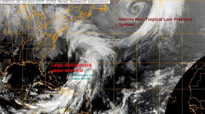
Well, the Tropical Atlantic has finally calmed down, save a few intense areas of low pressure, one a non-tropical entity in the far northern reaches of the Atlantic, and another disorganized upper level low east of the United States. This system will eventually become the significant rain-maker for the Northeast later this week.
No tropical development is anticipated in the next couple days.
Afternoon Update, and Cloudy Weather
Remaining Gloomy in DC
With this said, the new afternoon NAM is much drier, dousing the region with between .25 and .75" through Friday afternoon. Even with all the model uncertainty, it looks like the moisture trapped in the lower levels of the atmosphere really isn't going anywhere, and the low clouds and occasional drizzle will likely persist through the week. The best chance for any appreciable precip will be in the southeastern portion of MD and the eastern shore.
Tropics:
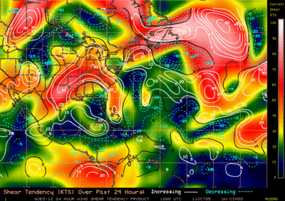
Much of the Atlantic has become very hostile for tropical development, with significant wind shear (>30 knots or about 35 mph) in the mid and upper levels of the atmosphere. There is, however, one very large and persistent mid/upper level feature spinning around about 400 miles off the east coast. The system is ragged, very large, and very disorganized at this time. Upper level winds are unfavorable for development, but this system still deserves a watchful eye.
An interesting stat that the Department of Commerce came up with in 1998 was that a 10% reduction in the amount of coastline warned could save nearly $20 million per storm, an issue that has come up time and time again at the Hurricane Center. It is true, however, that instruments and computer models are getting better as the decades slowly move along, and pressure towards Max Mayfield, director of the National Hurricane Center, has eased slightly in recent years.
The issue of whether or not the NHC should be allowed to disseminate warnings to the public has also been brought up. The new bill Rick Santorum would pass would effectively neutralize the Center's ability to make forecasts, and extend the challenge of forecasting to private weather industries like accuweather--a privately based company in Pennsylvania.
One point is certain in the issue of forecasting for significant weather events, however: the pressure is immense. The forecasts are putting people's lives at stake, and one wrong move could lead to disaster and public scrutiny-something the NHC has had to deal with over the years. Hopefully, forecasting techniques will improve rapidly over the coming years...
And we wave goodbye to Columbus Day
THE NATIONAL WEATHER SERVICE HAS ISSUED A FLOOD WATCH FOR THE METRO REGION EFFECTIVE 2AM TUESDAY THROUGH TUESDAY PM
Most locations around the region are reporting either mostly cloudy or completely overcast conditions at the 9:00 hour. Local radar shows scattered areas of light rain showers mainly south and west of a Warrenton to Fredericksburg line. The showers have very gradually been expanding in aerial coverage over the past few hours, and continue to move in a northeasterly fashion, and will likely overspread the DC metro region late tonight and tomorrow.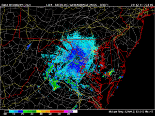
What's causing this rain now? Well, remember that cold front that ran through the region last weekend with the excess amount of rainfall? It's back. The front stalled over the extreme western Atlantic, and has been forced slowly westward by an upper low to the east. This old frontal boundary in association with another upper level low to the west should combine to form a soggy pattern for the next couple days. Some models are delivering between 1 and 2 inches of rainfall over the next 72 hours or so. Unlike last weekend's event, this rain will not all come in a short period of time, but should be extended over 3 or more days.
Tropical Beat:
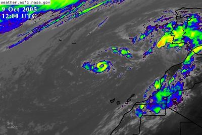
Vince has lost most of his punch over the past 24 hours with pretty much all of the thunderstorm activity being ripped off the center of circulation by strong westerly shear. Even though he has lost a lot of his punch, Vince may move into southern Portugal within the next day with some rain showers and gusty winds. You'd probably not even know this was a tropical system.
A vigorous and very large low pressure system is centered near 30N 67W and is associated with a mid-upper level low. Clouds and showers extend over a very wide area, from the central Caribbean Sea, eastward into the Lesser Antilles, and then into the western Atlantic--all associated with this low pressure feature. Development of this system is possible, as it remains nearly stationary over the Atlantic over the next couple of days.
Morning Update
Over the next 5 days, there will be at least a 30-40% chance of rain showers as moisture is locked in between a high pressure system to the north, and an upper level disturbance to the south. The graphic to the right is from the HPC (Hydrometeorological Prediction Center, and yes it is a mouthful) and displays the potential accumulated precipitation over the next 120 hours (5 Days). The rainfall, however, will not be anything like the stuff we say this weekend, but more of the 'light' variety.
Tropical Talk:
Former hurricane Vince, which formed in a very odd position yesterday a couple hundred miles west of Spain, has lost a lot of its punch overnight due to colder waters and upper level westerly shear. This is blasting the thunderstorms off the top of the low level center, which has decreased the storms intensity significantly.
There is one other area of disturbed weather east of the United States associated with an upper level low. This system is nearly stationary over the western Atlantic, and the NHC is expecting some slow development over the next several days. This system may affect the region this weekend/early next week with some rain showers...
A chance to dry out
 After a complete washout on Saturday, we have a chance to dry out before another round of showers moves in for Columbus Day and Tuesday. First off, a recap of yesterdays doozy of a rain-maker.
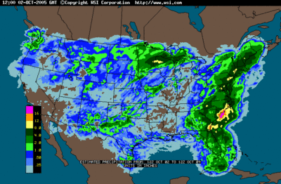
The image at right shows radar estimated rainfall accumulation for the entire United States from October 2 through the 9th. The image doesn't do complete justice, however to the entire region due to low resolution radar smoothing algorithms the intellicast radar uses.
Here a just a few rainfall totals, which can be accessed in full at The National Weather Service's Site:
Washington, DC: 7.34"
BWI: 6.72
Annapolis: 5.00"
Columbia: 8.87"
Bethesda: 5.52"
The highest official rain total I could find was in Fallston, MD in Harford county with a drenching 12.02"! With that said, Washington, DC broke its record for most rainfall in 24 hours (previously 1.49" back in 1996) with a total 3.67" yesterday.
The same holds true for both BWI and Dulles.
What to expect this week...
Current water vapor loop reveals a potent upper level low spinning around in the Tennessee Valley area near eastern Arkansas. Models forecast this system to move generally eastward over the next 24 hours, eventually moving into our region tomorrow morning/afternoon. The NAM develops light showers a little later than the GFS, and shows about .25 inches of rainfall accumulation by Wednesday. The GFS is a bit more aggressive and dumps between .5 and 1 inch of rain on the region by the same time.
Any way you look at it, another round of precip, albeit light, will once again encroach on the region tomorrow afternoon, and last possibly into the wee morning
Tropical Talk:
TD-22 is still spinning harmlessly south of Bermuda with winds around 35 mph. There is very little convection and organization chances look slim right now. Nonetheless, we will need to keep a close eye on this system as it may affect our regions weather come next weekend.
Tropical Storm Vince also formed this morning in a rather awkward position, about 200 miles southwest of Portugal! It is a very compact system with winds near 50 mph.
This storm may pose a rain threat to the Portugal/Spain area in about 4-6 days.
Other than that, the rest of the Atlantic is relatively quiet with only a few areas of convection noted on satellite. No tropical development is anticipated in the next 1-2 days.
Heavy rain pulling away
 An absolute drenching has affected the region for the past 36 hours. Some locations in central/western MD have reported rainfall accumulations in excess of 6", with some areas reporting totals approaching 10"! Numerous flood warnings remain in effect until midnight due to runoff from today's rains, mainly affecting the low lying portions of the region.
A very slowly moving cold front is located just east of Washington, DC/Baltimore and continues to inch closer to the Atlantic Ocean. This is effectively shoving the heaviest precipitation east towards the Chesapeake Bay. Even with the front passing, there is enough moisture left in the atmosphere to keep the chances of light showers across the entire region through the night.
Tomorrow, while there will not be nearly as much rain in the region,
clouds will hang tough and backlash from the departing front may promote the development of more isolated showers across the area.
Columbus Day and Tuesday develop a whole host of new problems as a weak wave of spin in the atmosphere ripples northeast into the Mid Atlantic late Monday. At this point, too many details have yet to be worked out, so a small 40% chance of showers is called for Monday Afternoon/Tuesday.
Tropical Talk:
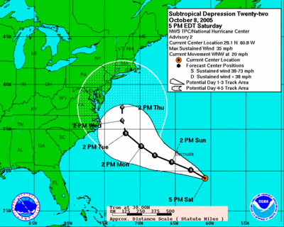
Sub-tropical depression 22 developed earlier today a few hundred miles east or northern Florida. A subtropical depression is basically the same thing as a 'normal' depression (you wouldn't know the difference if you were in one), but also has some characteristics of an extratropical cyclone (a cyclone with no characteristics of a tropical entity).
Sub-TD 22 is moving basically off to the northwest, with a general motion towards the north in 5-6 days as a trough/cold front approach it from the west. At this point, very few affects from this system are expected with a recurvature out to sea, but nearly 5 days separates us from this event getting anywhere near the coast.
Tropical Deluge in DC
FLOOD WARNINGS ARE NOW IN EFFECT FOR NUMEROUS COUNTIES AROUND THE DC AREA. RADAR INDICATES NEARLY 6 INCHES OF RAIN HAS FALLEN IN MANY LOCATIONS, AND ANOTHER 2-4 INCHES WILL BE POSSIBLE TODAY. <
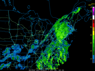 Light to moderate rainfall continues over pretty much the entire Mid Atlantic region, with a few pockets of heavy precipitation--one situated over eastern Montgomery County and moving off to the northeast around 20 mph. Regional radar mosaic displays a shield or rain all up and down the east coast in association with a strong cold front and various waves of low pressure developing along it. Even though this rain event will likely ruin at least the beginning of the weekend, this is a welcome drenching as rainfall deficits around the region were approaching 4".
Light-moderate rain showers will continue for the overnight hours and into the day tomorrow. There is some question regarding tomorrow's forecast on how fast the cold front clears the region. Unlike the NAM, the GFS doesn't stall the cold front along the Eastern Shore but moves it briskly out to sea--taking most of the rain with it. The NAM, on the other hand, is more groggy, and stalls the front out Sunday morning, keeping the showers on hand through Monday. The latter model even depicts some retrogression of the cold front, ie. movement opposite the mean flow of the atmosphere--to the west, during Monday.
A compromise between the two models looks good right now, with rain showers continuing through midday Sunday before the front clears the area. Cloudy conditions and a 40% chance of scattered showers will, however, persist through the day, and possibly into Monday.
Tropical Talk:
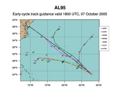
Another area of disturbed weather has developed over the central Atlantic, earmarked 94L. The National Hurricane Center is keeping a close eye on this system as noted in their Tropical Weather Outlook:
A NON-TROPICAL LOW PRESSURE AREA CENTERED ABOUT 550 MILES NORTHEAST
OF THE LEEWARD ISLANDS CONTINUES TO SHOW SIGNS OF ORGANIZATION.
THIS SYSTEM HAS SOME POTENTIAL FOR TROPICAL OR SUBTROPICAL
DEVELOPMENT OVER THE NEXT DAY OR TWO AS IT MOVES WEST-NORTHWESTWARD
AT 10 TO 15 MPH.
The above picture is a graphic showing several computer models that forecast the movement of tropical systems. The black line is not, however, a model, but a linear extrapolation based on the system's current movement (NW near 20mph).
The disturbance is currently in an area of favorable surface and upper level conditions--and some slow development of this system is possible over the next few days.


