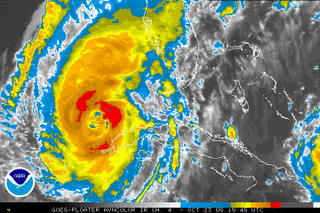
 Hurricane Wilma:
As of 2PM EDT, Wilma was still a category 2 hurricane with maximum sustained winds around 100mph. There have been a few indications that Wilma is trying to re-strengthen over the warm Gulf waters, such as a collapsing inner eye wall and expanding cold cloud tops, but surface winds have not really moved today. A Hurricane Hunter reconaissance aircraft is currently flying in and out of the storm, sending data via dropsonde samples back to the Hurricane HQ in Miami, Florida.
Wilma has begun to accelerate ahead of an approaching trough of low pressure in the mid levels centered through the nation's midsection. Given the present foreword movement and somewhat favorable conditions in the southern Gulf of Mexico, it appears Wilma will make landfall as a major category 3 storm somewhere between Naples, and Boca Grande, Florida bright and early Monday morning.
Wilma's repercussions this week:
As Tropical Storm Alpha continues to get chewed up by the mountainous terrain of Hispanola, Wilma will continue to trudge eastward into the ever popular state for landfall that is Florida. There is some increasing concern that Wilma throws some wet and windy weather our way as the new work week begins.
Tonight and tomorrow, a trough in the mid and upper levels of the atmosphere (basically a lowering of atmospheric height) cuts its way through Illinois and Ohio, gradually assuming a position just west of the Mid Atlantic region Monday evening. As this happens, what's left of Wilma and former TS Alpha merge off the east coast. Recent runs of the Global Forecast System Model (GFS), UKMET, ECMWF, and Canadian have unanimously re-introduced Wilma as a key player in our weather Monday night/Tuesday.
While there is still confusion as to how close Wilma makes it to the East Coast still exists, there is an increasing threat of some early-week rain/wind in Mid Atlantic and Northeast. Again, how much rainfall/wind we receive is directly related to how close Wilma makes it to the seaboard.
Here are a few quick scenarios with respect to the Monday/Tuesday timeframe:
[1] Most Likely: The closest approach Wilma makes on the region is about 100 miles offshore early Tuesday morning. If this scenario is correct, the most our region would see from the accelerating storm system would be gusty winds around 15-30mph, and rainfall totals averaging less than 1".
[2] In-between: Wilma's closest approach to the region is between 50 and 99 miles as it grazes the East Coast. This would result in winds approaching 30-45 mph in some gusts, and rainfall totals near 2-3 inches.
[3] Least likely: Wilma basically makes landfall along the Eastern Seaboard and rides northeast into the Canadian Maritimes. Wind gusts would approach 50 mph with rainfall totals ranging from 4-6 inches.


for this post
Leave a Reply