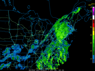
FLOOD WARNINGS ARE NOW IN EFFECT FOR NUMEROUS COUNTIES AROUND THE DC AREA. RADAR INDICATES NEARLY 6 INCHES OF RAIN HAS FALLEN IN MANY LOCATIONS, AND ANOTHER 2-4 INCHES WILL BE POSSIBLE TODAY. <
 Light to moderate rainfall continues over pretty much the entire Mid Atlantic region, with a few pockets of heavy precipitation--one situated over eastern Montgomery County and moving off to the northeast around 20 mph. Regional radar mosaic displays a shield or rain all up and down the east coast in association with a strong cold front and various waves of low pressure developing along it. Even though this rain event will likely ruin at least the beginning of the weekend, this is a welcome drenching as rainfall deficits around the region were approaching 4".
Light-moderate rain showers will continue for the overnight hours and into the day tomorrow. There is some question regarding tomorrow's forecast on how fast the cold front clears the region. Unlike the NAM, the GFS doesn't stall the cold front along the Eastern Shore but moves it briskly out to sea--taking most of the rain with it. The NAM, on the other hand, is more groggy, and stalls the front out Sunday morning, keeping the showers on hand through Monday. The latter model even depicts some retrogression of the cold front, ie. movement opposite the mean flow of the atmosphere--to the west, during Monday.
A compromise between the two models looks good right now, with rain showers continuing through midday Sunday before the front clears the area. Cloudy conditions and a 40% chance of scattered showers will, however, persist through the day, and possibly into Monday.
Tropical Talk:
Another area of disturbed weather has developed over the central Atlantic, earmarked 94L. The National Hurricane Center is keeping a close eye on this system as noted in their Tropical Weather Outlook:
A NON-TROPICAL LOW PRESSURE AREA CENTERED ABOUT 550 MILES NORTHEAST
OF THE LEEWARD ISLANDS CONTINUES TO SHOW SIGNS OF ORGANIZATION.
THIS SYSTEM HAS SOME POTENTIAL FOR TROPICAL OR SUBTROPICAL
DEVELOPMENT OVER THE NEXT DAY OR TWO AS IT MOVES WEST-NORTHWESTWARD
AT 10 TO 15 MPH.
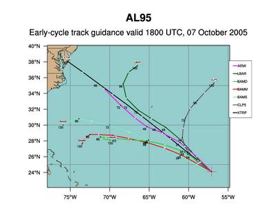
The above picture is a graphic showing several computer models that forecast the movement of tropical systems. The black line is not, however, a model, but a linear extrapolation based on the system's current movement (NW near 20mph).
The disturbance is currently in an area of favorable surface and upper level conditions--and some slow development of this system is possible over the next few days.


for this post
Leave a Reply