With this said, the new afternoon NAM is much drier, dousing the region with between .25 and .75" through Friday afternoon. Even with all the model uncertainty, it looks like the moisture trapped in the lower levels of the atmosphere really isn't going anywhere, and the low clouds and occasional drizzle will likely persist through the week. The best chance for any appreciable precip will be in the southeastern portion of MD and the eastern shore.
Tropics:
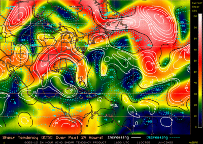
Much of the Atlantic has become very hostile for tropical development, with significant wind shear (>30 knots or about 35 mph) in the mid and upper levels of the atmosphere. There is, however, one very large and persistent mid/upper level feature spinning around about 400 miles off the east coast. The system is ragged, very large, and very disorganized at this time. Upper level winds are unfavorable for development, but this system still deserves a watchful eye.
Wind shear (mid and upper levels) in the Atlantic. Areas of 30kts or greater (yellowish color) are generally unfavorable for tropical development
An article that appeared in Today's Miami Herald talks about how breakdowns in observation equipment/Noaa Hurricane Hunter Aircraft, failure to launch weather balloons in the Caribbean, etc., have caused a breakdown in how the National Hurricane Center makes its forecasts. The article points out that 1998, forecasters warned nearly 900 miles of coastline from Louisiana to the Florida Panhandle, while hurricane force winds only affected a 200 or so mile stretch of land, leaving 700 miles untouched.
An interesting stat that the Department of Commerce came up with in 1998 was that a 10% reduction in the amount of coastline warned could save nearly $20 million per storm, an issue that has come up time and time again at the Hurricane Center. It is true, however, that instruments and computer models are getting better as the decades slowly move along, and pressure towards Max Mayfield, director of the National Hurricane Center, has eased slightly in recent years.
The issue of whether or not the NHC should be allowed to disseminate warnings to the public has also been brought up. The new bill Rick Santorum would pass would effectively neutralize the Center's ability to make forecasts, and extend the challenge of forecasting to private weather industries like accuweather--a privately based company in Pennsylvania.
One point is certain in the issue of forecasting for significant weather events, however: the pressure is immense. The forecasts are putting people's lives at stake, and one wrong move could lead to disaster and public scrutiny-something the NHC has had to deal with over the years. Hopefully, forecasting techniques will improve rapidly over the coming years...


for this post
Leave a Reply