 After a complete washout on Saturday, we have a chance to dry out before another round of showers moves in for Columbus Day and Tuesday. First off, a recap of yesterdays doozy of a rain-maker.
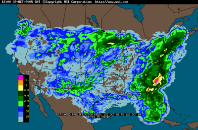
The image at right shows radar estimated rainfall accumulation for the entire United States from October 2 through the 9th. The image doesn't do complete justice, however to the entire region due to low resolution radar smoothing algorithms the intellicast radar uses.
Here a just a few rainfall totals, which can be accessed in full at The National Weather Service's Site:
Washington, DC: 7.34"
BWI: 6.72
Annapolis: 5.00"
Columbia: 8.87"
Bethesda: 5.52"
The highest official rain total I could find was in Fallston, MD in Harford county with a drenching 12.02"! With that said, Washington, DC broke its record for most rainfall in 24 hours (previously 1.49" back in 1996) with a total 3.67" yesterday.
The same holds true for both BWI and Dulles.
What to expect this week...
Current water vapor loop reveals a potent upper level low spinning around in the Tennessee Valley area near eastern Arkansas. Models forecast this system to move generally eastward over the next 24 hours, eventually moving into our region tomorrow morning/afternoon. The NAM develops light showers a little later than the GFS, and shows about .25 inches of rainfall accumulation by Wednesday. The GFS is a bit more aggressive and dumps between .5 and 1 inch of rain on the region by the same time.
Any way you look at it, another round of precip, albeit light, will once again encroach on the region tomorrow afternoon, and last possibly into the wee morning
Tropical Talk:
TD-22 is still spinning harmlessly south of Bermuda with winds around 35 mph. There is very little convection and organization chances look slim right now. Nonetheless, we will need to keep a close eye on this system as it may affect our regions weather come next weekend.
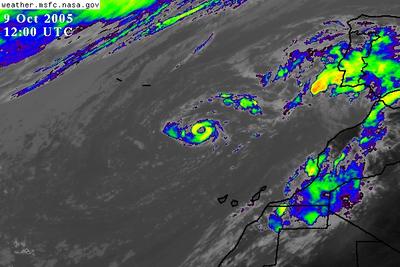
Tropical Storm Vince also formed this morning in a rather awkward position, about 200 miles southwest of Portugal! It is a very compact system with winds near 50 mph.
This storm may pose a rain threat to the Portugal/Spain area in about 4-6 days.
Other than that, the rest of the Atlantic is relatively quiet with only a few areas of convection noted on satellite. No tropical development is anticipated in the next 1-2 days.


for this post
Leave a Reply