UPDATE:
Clouds are rapidly dissipating across the region as moisture rockets towards the northeast. Expect mainly sunny to partly cloudy conditions today--and make sure to bundle up as high temperatures will be hard pressed to make it into the mid 50s in the District.
Winds will also make it feel like late Autumn as they gusts to 20-30mph; however they will not entirely associated with the departing Nor'easter, rather, winds mixing down from a couple thousand feet up will add to the blustery conditions. The winds pick up after sunrise today.
DC's Record Rainfall:
Ever since the 6th of October, rain gauges across the region have begun recording precip totals to what has now become the wettest October in history for the DC metro region. From the 6th-8th, a strong low pressure system and stalled frontal boundaries dumped over 7 inches of rain at DC's Reagan National Airport. From the 11th to the 14th, several waves of low pressure skirted the region, delivering marginal precip totals near a quarter of an inch. And today, with a strengthening Nor'easter moving up the East Coast, Washington, DC eclipsed its previous rainfall record of 8.81 inches set back in 1937 at 1PM EDT. Since then, the rain gauge at Reagan National Airport has continued to fill, bringing the monthly total to a staggering 9.32 inches.
Likewise, BWI also reports rainfall totals now eclipsing 9.5 inches, shattering the old record of 8.41 inches set back in 1941.
It's absolutely incredible that last month it seemed like we couldn't buy a day of rainfall, with less than .11" falling in a period of 30 days-and now we have rainfall records the very next month. Still, October of 2005 cannot compare with the September of 1934 when over 17 inches of rain fell in that 30 day period.
Regional Outlook:
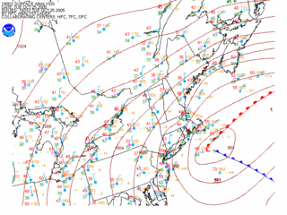
With respect to this latest rain event, I can safely say that Wilma was NOT the main weather player in this set-up. As indicated in the previous post, a low pressure/nor'easter-esque scenario developed as an upper low on the western flank of the Appalachians transferred energy to the east coast. The low now sits as it deepens/strengthens just south of Cape Cod. The Washington Post published an article on this storm this afternoon.
Tonight, the said low pressure system pulls northeast into the Grand Banks, leaving us with a cold, mostly cloudy day tomorrow. Given some residual low level moisture--at least in the lower levels--a small chance (30% or less) of showers will persist through at least the morning hours tomorrow, until the intense low pulls the remaining moisture out of the region.
At least through Friday, high temperatures will have a hard time making it into the upper 50s as northwesterly winds draw in cooler Canadian Air.
After Saturday, there is some light at the end of the tunnel as highs try to moderate into the upper 50s/60s as high pressure settles in overhead.
Clouds are rapidly dissipating across the region as moisture rockets towards the northeast. Expect mainly sunny to partly cloudy conditions today--and make sure to bundle up as high temperatures will be hard pressed to make it into the mid 50s in the District.
Winds will also make it feel like late Autumn as they gusts to 20-30mph; however they will not entirely associated with the departing Nor'easter, rather, winds mixing down from a couple thousand feet up will add to the blustery conditions. The winds pick up after sunrise today.
DC's Record Rainfall:
Ever since the 6th of October, rain gauges across the region have begun recording precip totals to what has now become the wettest October in history for the DC metro region. From the 6th-8th, a strong low pressure system and stalled frontal boundaries dumped over 7 inches of rain at DC's Reagan National Airport. From the 11th to the 14th, several waves of low pressure skirted the region, delivering marginal precip totals near a quarter of an inch. And today, with a strengthening Nor'easter moving up the East Coast, Washington, DC eclipsed its previous rainfall record of 8.81 inches set back in 1937 at 1PM EDT. Since then, the rain gauge at Reagan National Airport has continued to fill, bringing the monthly total to a staggering 9.32 inches.
Likewise, BWI also reports rainfall totals now eclipsing 9.5 inches, shattering the old record of 8.41 inches set back in 1941.
It's absolutely incredible that last month it seemed like we couldn't buy a day of rainfall, with less than .11" falling in a period of 30 days-and now we have rainfall records the very next month. Still, October of 2005 cannot compare with the September of 1934 when over 17 inches of rain fell in that 30 day period.
Regional Outlook:

With respect to this latest rain event, I can safely say that Wilma was NOT the main weather player in this set-up. As indicated in the previous post, a low pressure/nor'easter-esque scenario developed as an upper low on the western flank of the Appalachians transferred energy to the east coast. The low now sits as it deepens/strengthens just south of Cape Cod. The Washington Post published an article on this storm this afternoon.
Tonight, the said low pressure system pulls northeast into the Grand Banks, leaving us with a cold, mostly cloudy day tomorrow. Given some residual low level moisture--at least in the lower levels--a small chance (30% or less) of showers will persist through at least the morning hours tomorrow, until the intense low pulls the remaining moisture out of the region.
At least through Friday, high temperatures will have a hard time making it into the upper 50s as northwesterly winds draw in cooler Canadian Air.
After Saturday, there is some light at the end of the tunnel as highs try to moderate into the upper 50s/60s as high pressure settles in overhead.


for this post
Leave a Reply