First off, the rest of the weekend looks spectacular, no complaints here. As anticipated, winds were a bit gusty today, ranging anywhere from 10-30 mph, but have subsided due to nocturnal cooling of the atmosphere. Winds may again pick up tomorrow, but should not be as blustery--likely remaining below 25 mph. High temperatures should struggle to get out of the upper 60s; undoubtedly one of the best weekends we've had here in a long time.
Talkin' Tropics:
Tropical Depression 24 developed earlier today in the western Caribbean with maximum sustained winds around 30 mph. The depression continues to become better organized, and will likely become Tropical Storm Wilma early tomorrow. There is some uncertainty as to where TD-24 heads given its slow foreword progression. Most models keep the depression nearly stationary/slight westward drift over the next 2-3 days, and then begin to accelerate it up to the northwest, and then north over the western tip of Cuba.
 The European Model (ECMWF) seems to have a relatively good handle on this system, which eventually draws it northward into eastern Florida Saturday morning. The more bullish GFDL model takes TD-24 on a similar track, but intensifies it to a catastrophic category 5 hurricane over the extreme western Caribbean in a little under 5 days. This seemed a little over the top, and subsequent runs of the said model have backed down slightly on forecast intensity.
Other models, such as the Canadian and GFS, develop the system much quicker than the ECMWF, and have the system sitting due east of Newfoundland the same time the Euro has the storm off Florida. The National Hurricane Center seems to be following the ECMWF and other operational hurricane models to forecast this systems movement.
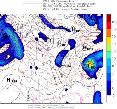
Going back to the Canadian's analysis of this situation; if one were to follow this model (which, at least in my opinion is a strong model to add to the forecasting arsenal) we would have a very powerful hurricane sitting off the outerbanks of NC Thursday afternoon.

At this point in time, there are far too many variables that have the potential to change significantly over the next several days to make a confident prediction regarding TD-24's movements. However, it is in the best interest of anyone living in the western Caribbean, including western Cuba and Central America to keep a very close eye on this system. It is forecast to become a hurricane, and possibly a severe one with winds in excess of 110 mph. Florida is the target at this time, but details will be worked out over the coming days.
Given the presence of a powerful low pressure system somewhere along the Eastern Seaboard, there may be some repercussions around the Mid Atlantic and Northeast in the coming weeks. A majority of the mid and long range models develop a powerful early-autumn trough of low pressure around the Great Lakes region in the next 7-10 days. The set up here would favor the first snowfall in the northeast, and very cold temperatures in the Mid Atlantic.
Granted, the time frame for the forecast here is wicked...nearly 200 hours out, but this is something to watch in the coming days.


for this post
Leave a Reply