A FROST ADVISORY IS IN EFFECT FOR AREAS WEST OF THE DISTRICT IN RESPONSE TO EXPECTED LOW TEMPERATURES DIPPING INTO THE LOW-MID 30S.

Scattered clouds, low sun-angle, and stiff northwesterly winds all combined to produce a chilly autumn afternoon in the Nation's Capital region. High temperatures today were generally kept in the mid 50s-and these below average temperatures combined with occasional wind gusts to 30 mph made for one of those days where you just want to bundle up or stay indoors.
Tonight, we have the chance of seeing the first frost of the season (which would effectively end the growing season for locations that do develop a frost). Mostly clear to partly cloudy conditions, along with light winds and a dry surface layer, temperatures will fall quickly off towards the dewpoint value in the lower 40s. The best chance for frost will, however, be confined to areas north and west of the immediate metro region.
The coldest part of the day is normally just before sunrise, and we expect temperatures at that time to range from the mid-upper 30s in town, to near 30 out in the western 'burbs. Any plants you have left outside that are susceptible to dying when introduced to sub 32 temps should be brought inside tonight.
Temperatures try to warm back into the mid 50s tomorrow under partly cloudy conditions.
Image above right: Light blue are frost advisories, cyan color are freeze warnings. Image courtesy of Theweathercenter.com
Extended Outlook:
High temperatures begin to moderate somewhat over the weekend as high pressure noses into the region. Highs next Sunday may approach 60F, and possibly make it to near 70 by Monday. Other than this, nothing of any significant importance develops during the time frame from this Friday until next week.
Tropical Talk:
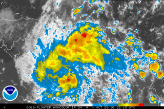
Just when it seems the tropics cannot possibly get any more active, two separate entities in the tropical Atlantic basin bear monitoring for development over the next hours and days. The first is a relatively well defined cluster of thunderstorms and a low pressure center the Nicaragua/Costa Rica regions. Conditions appear to be relatively favorable for continued development over the next few days as it drifts slowly north (although the exact motion is quite hard to piece out at the moment).
 The second area of disturbed weather is located around the Lesser Antilles. Although upper level conditions are not particularly favorable for any significant development, conditions may become a bit more conducive for development over the next several days.
The next storm name on our 'list' is Beta.
Winter storm out west:
Yesterday, nearly 1 foot of snow fell in Garret County, and upwards of 4-6 inches in isolated locations of central PA.


for this post
Leave a Reply