A FROST ADVISORY IS IN EFFECT FOR SOUTHERN WEST VIRGINIA TONIGHT.
Weather recap:So we got through Saturday and Sunday with some sunshine for a change, although the wind today made it feel a bit brisk out there (it is autumn after all). The high temperature today was only 68F due to very strong cold air advection (basically just cold air being transported into the region from the northwest).
The highest wind speeds I could find were from our home Reagan National Airport wth the highest sustained wind peaking at 28 mph, and the highest gust at 37 mph.
Weather over the next few days:
Tomorrow, winds slacken as low pressure pulls away to the northeast over the Canadian Maritimes. At the same time, weak high pressure attemps to push northeastward into the region from the southwest, effectively washing out any leftover moisture in the atmosphere, yielding a gorgeous early-autumn afternoon. Highs tomorrow will again struggle to make it out of the 60s (I'm going with a high of 69*F for DC).
Temperatures begin to moderate somewhat Tuesday through Thursday as high pressure encroaches on the region. We may once again approach 80 for highs by Thursday.
 Some confused computer models
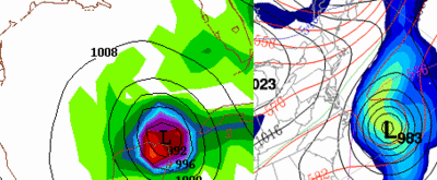
After Thursday, the forecast becomes a bit more tricky. The GEM computer model, run by the Canadian Environment Center, remains emphatic on drawing an intense low pressure system (soon-to-be Wilma) up the east coast, to a location just about 100 miles east of Charleston, SC Thursday night. The GFS paints a completely different story, drawing TD-24 between the Yucatan Pennisula and the western tip of Cuba valid the same time.
The GFS later slams this storm (a hurricane most likely) into the western Florida panhanlde Sunday morning. Another solution comes from the ECMWF (The European Center for Medium-Range Weather Forecasting), which seems to split the two model forecasts. The Euro moves this storm to a landfall location a bit farther south to near the Punta Gorda, FL area Sunday morning, then traverses the low across the state, emerging it back into the atlantic.
The highest wind speeds I could find were from our home Reagan National Airport wth the highest sustained wind peaking at 28 mph, and the highest gust at 37 mph.
Weather over the next few days:
Bundle up the next few mornings as you head out the door. Clear skies, calming winds, and low dewpoints will favor temperatures dipping into the lower 40s in the DC 'burbs
Tomorrow, winds slacken as low pressure pulls away to the northeast over the Canadian Maritimes. At the same time, weak high pressure attemps to push northeastward into the region from the southwest, effectively washing out any leftover moisture in the atmosphere, yielding a gorgeous early-autumn afternoon. Highs tomorrow will again struggle to make it out of the 60s (I'm going with a high of 69*F for DC).
Temperatures begin to moderate somewhat Tuesday through Thursday as high pressure encroaches on the region. We may once again approach 80 for highs by Thursday.
 Some confused computer models
After Thursday, the forecast becomes a bit more tricky. The GEM computer model, run by the Canadian Environment Center, remains emphatic on drawing an intense low pressure system (soon-to-be Wilma) up the east coast, to a location just about 100 miles east of Charleston, SC Thursday night. The GFS paints a completely different story, drawing TD-24 between the Yucatan Pennisula and the western tip of Cuba valid the same time.
The GFS later slams this storm (a hurricane most likely) into the western Florida panhanlde Sunday morning. Another solution comes from the ECMWF (The European Center for Medium-Range Weather Forecasting), which seems to split the two model forecasts. The Euro moves this storm to a landfall location a bit farther south to near the Punta Gorda, FL area Sunday morning, then traverses the low across the state, emerging it back into the atlantic.


for this post
Leave a Reply