Regional Satellite images reveal clear skies with only a few flakes of puffy clouds in western Maryland, and eastern West Virginia. Temperatures will soar to near 80 today, a number we haven't seen from the reporting stations since October 6th...that's over a week.
Temperatures tomorrow should be a tad cooler due to a lesser amount of something called downsloping. This phenomenon occurs when air traverses mountain chains (in this case the Appalachian Mountains), usually at a right angle, which is what is occuring today. The effects of downsloping winds are very simple: increased temperatures, lower humidity, and a stable environment. Forecasters often look at the 700mb progs (weather forecasts for the level around 9000 feet or so, however this can change dramatically with nearby lows/highs) to determine where strong downsloping winds may occur.
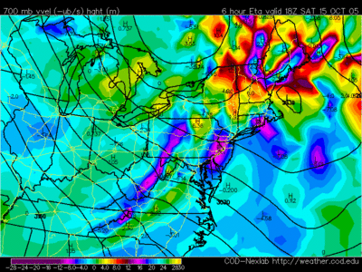
Take today's six hour forecast valid this afternoon from the North American Mesoscale Model run by the NCEP (National Center for Environmental Protection). This map shows areas of positive or negative vorticity (basically just "spin" in the atmosphere). Notice the dark purples on the western flank of the Appalachian Mountains--that's negative vorticity, a great indicator of a downsloping wind effect on the region.
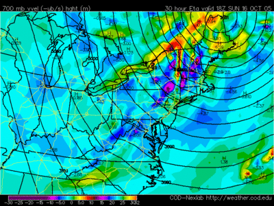
 Now check out the prog for the afternoon on Sunday. There is significantly less pronounced negative vorticity west of the Appalachians, hence, the downsloping component should be minimal. So, temperatures will not be moderated as much yielding the cooler high temperatures in the upper 60s to near 70.
Tropical Weather:
A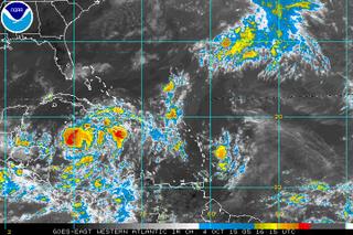 n aircraft reconaissance mission into an area of disturbed weather in the western Caribbean is scheduled for this afternoon. The area of convection near Jamaica has continued to organize, and looks like a tropical depression at the moment. My guess is the Hurricane Center upgrades this system this afternoon in its 5:00 update.
Sea surface temperatures in the western Caribbean are extraordinarly high, with isolated readings around 32C (90F).
The overall movement of this system is uncertain, and computer models are spread over a wide area, confused as to where this system goes after today. Once the recon aircraft gets into the system and can report some observations back, models will have more data to ingest to help forecast this systems movement. Interests near the Yucatan, and around the entire western Caribbean should monitor the progression of this system closely.
(And if this does make it Tropical storm strength, it would be named Wilma).
Temperatures tomorrow should be a tad cooler due to a lesser amount of something called downsloping. This phenomenon occurs when air traverses mountain chains (in this case the Appalachian Mountains), usually at a right angle, which is what is occuring today. The effects of downsloping winds are very simple: increased temperatures, lower humidity, and a stable environment. Forecasters often look at the 700mb progs (weather forecasts for the level around 9000 feet or so, however this can change dramatically with nearby lows/highs) to determine where strong downsloping winds may occur.
Take today's six hour forecast valid this afternoon from the North American Mesoscale Model run by the NCEP (National Center for Environmental Protection). This map shows areas of positive or negative vorticity (basically just "spin" in the atmosphere). Notice the dark purples on the western flank of the Appalachian Mountains--that's negative vorticity, a great indicator of a downsloping wind effect on the region.
 Now check out the prog for the afternoon on Sunday. There is significantly less pronounced negative vorticity west of the Appalachians, hence, the downsloping component should be minimal. So, temperatures will not be moderated as much yielding the cooler high temperatures in the upper 60s to near 70.
Tropical Weather:
A
 n aircraft reconaissance mission into an area of disturbed weather in the western Caribbean is scheduled for this afternoon. The area of convection near Jamaica has continued to organize, and looks like a tropical depression at the moment. My guess is the Hurricane Center upgrades this system this afternoon in its 5:00 update.
Sea surface temperatures in the western Caribbean are extraordinarly high, with isolated readings around 32C (90F).
The overall movement of this system is uncertain, and computer models are spread over a wide area, confused as to where this system goes after today. Once the recon aircraft gets into the system and can report some observations back, models will have more data to ingest to help forecast this systems movement. Interests near the Yucatan, and around the entire western Caribbean should monitor the progression of this system closely.
(And if this does make it Tropical storm strength, it would be named Wilma).


I'm serious, webpages need color