 UPDATE:
Hurricane Wilma is now undergoing rapid intensification in the western Caribbean. In the last three hours, pressures have fallen close to 20mb...an absolutely incredible pressure drop by meteorological standards. Winds have therefore increased to near 100mph, making Wilma a strong category 2 hurricane on the Saffir-Simpson hurricane scale.
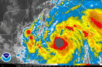
The image at right is the IR image from 8:15 PM EDT. Notice the extremely cold cloud top temperatures around the center of the storm...close to -80C (you probably wouldn't want to be out in temperatures that cold, that's about -115*F). Also, draw your attention to that little hole in the center of the coldest cloud tops--that's the hurricanes eye starting to develop.
Continued strengthening is anticipated through the day tomorrow.
Next Few Days:
We get treated to another spectacular day as temperatures crawl into the mid 70s under mainly sunny skies. There is again a hint of downsloping and compressional heating as air rises over the peaks of the Appalachian mountains, and then descends into the Shenandoah Valley. The air warms as it looses altitude, spreading the absolutely perfect highs into the region.
On Wednesday, winds become more southerly, again pumping in high temperatures into the mid/upper 70s.
A Cold front moves through the region Thursday morning. Clouds and a northwesterly wind will likely keep high temperatures down in the mid 60s. At this point, precipitation chances are quite low--generally less than 30% through the day Thursday, but we can't rule out the chance that you run into a stray shower. The front then clears the region Thursday afternoon, drawing in cooler air for Friday. We'll still likely be under the influence of a moist flow off the ocean, so expect mostly cloudy conditions through Friday morning and afternoon.
Talkin' about the Tropics:
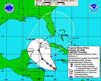
Tropical Storm Wilma has gained some steam, and maximum sustained winds are now near 70 mph--and Wilma is expected to become a hurricane Later today or tonight.
 The movement of Wilma, at least in the next 4-5 days is relatively certain. A northwestward drift towards the eastern Yucatan Peninsula, and then a sharp turn to the northeast towards the southern tip of Florida Sunday.
The problems arise after day 5, when models diverge on possible scenarios.
Over the weekend, the GFS develops a very deep upper level low pressure system in the Midwest, which attempts to "phase" with the approach of Wilma, but fails to completely do so, resulting in what forecasters call a "linkage".
This scenario would result in moderate rainfall for the region, and gusty winds from 15-30 mph.
Another Scenario, although less likely, still remains possible--Wilma misses the upper low to the west, and continues its treck out to sea, with minimal effects on the region.
A final solution is a full phase of Wilma, meaning the low gets completely absorbed into the upper low in the Midwest/Ohio River Valley area. This would result in catastrophic flooding for the already rain-soaked Mid Atlantic and Northeast, and the wind associated with the storm would further jeopardize the weakened roots of the trees.
The GFS, on its current run, develops about 1-5 inches of rainfall across the entire Mid Atlantic/Northeast regions. We will continue to monitor the forecasts over the week--and my current thinking is a semi-phase/linkage will occur, which would result in a moderate to heavy rainfall event for the region early next week.
The image at right is the IR image from 8:15 PM EDT. Notice the extremely cold cloud top temperatures around the center of the storm...close to -80C (you probably wouldn't want to be out in temperatures that cold, that's about -115*F). Also, draw your attention to that little hole in the center of the coldest cloud tops--that's the hurricanes eye starting to develop.
Continued strengthening is anticipated through the day tomorrow.
Next Few Days:
We get treated to another spectacular day as temperatures crawl into the mid 70s under mainly sunny skies. There is again a hint of downsloping and compressional heating as air rises over the peaks of the Appalachian mountains, and then descends into the Shenandoah Valley. The air warms as it looses altitude, spreading the absolutely perfect highs into the region.
On Wednesday, winds become more southerly, again pumping in high temperatures into the mid/upper 70s.
A Cold front moves through the region Thursday morning. Clouds and a northwesterly wind will likely keep high temperatures down in the mid 60s. At this point, precipitation chances are quite low--generally less than 30% through the day Thursday, but we can't rule out the chance that you run into a stray shower. The front then clears the region Thursday afternoon, drawing in cooler air for Friday. We'll still likely be under the influence of a moist flow off the ocean, so expect mostly cloudy conditions through Friday morning and afternoon.
Talkin' about the Tropics:
Tropical Storm Wilma has gained some steam, and maximum sustained winds are now near 70 mph--and Wilma is expected to become a hurricane Later today or tonight.
 The movement of Wilma, at least in the next 4-5 days is relatively certain. A northwestward drift towards the eastern Yucatan Peninsula, and then a sharp turn to the northeast towards the southern tip of Florida Sunday.
The problems arise after day 5, when models diverge on possible scenarios.
Over the weekend, the GFS develops a very deep upper level low pressure system in the Midwest, which attempts to "phase" with the approach of Wilma, but fails to completely do so, resulting in what forecasters call a "linkage".
This scenario would result in moderate rainfall for the region, and gusty winds from 15-30 mph.
Another Scenario, although less likely, still remains possible--Wilma misses the upper low to the west, and continues its treck out to sea, with minimal effects on the region.
A final solution is a full phase of Wilma, meaning the low gets completely absorbed into the upper low in the Midwest/Ohio River Valley area. This would result in catastrophic flooding for the already rain-soaked Mid Atlantic and Northeast, and the wind associated with the storm would further jeopardize the weakened roots of the trees.
The GFS, on its current run, develops about 1-5 inches of rainfall across the entire Mid Atlantic/Northeast regions. We will continue to monitor the forecasts over the week--and my current thinking is a semi-phase/linkage will occur, which would result in a moderate to heavy rainfall event for the region early next week.


for this post
Leave a Reply