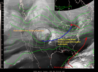
This is pretty much the last full day of "nice" weather around the region for awhile. Tomorrow, clouds thicken in response to an advancing cold front that will move through the region late tonight/early tomorrow morning.
 Due to increasing cloud cover and winds shifting around to the north, high temperatures will likely be held at bay in the mid 60s.
All indications point to a pretty much dry frontal passage (aka FROPA in weather jargon), however, an isolated shower cannot be ruled out Thursday afternoon.
Clouds will hang around into Friday. At the same time, a ripple in the atmosphere in the form of an upper level trough will slide east from the Rocky mountains, and will likely spread some light rain showers over the Mid Atlantic states Friday afternoon. After this, the forecast becomes quite tricky...
Extended Outlook:
Early Saturday morning, in the south central provinces of Canada, an upper level low will be developing--rather harmlessly as it slowly progresses southeastward into the Contiguous United States. By Sunday morning, this upper low has made its way into the Ohio River Valley, south of Lake Michigan.
The low discussed earlier that had moved in from the west on Friday will still be spinning around in the New England region. As the upper low approaches from the west, the surface low phases with it, forming a large and complex area of disturbed weather over the Great Lakes region, possibly inducing the years first lake effect rain/snow showers. The presence of this strong duo-of low pressure systems will keep the chance of showers in the region all the way into next week, when yet another factor comes into play..
Hurricane Wilma...which was the strongest hurricane ever recorded in Atlantic Basin history with a minimum central pressure of 882mb this morning, will continue its slow journey through the western Caribbean over the next two days. By Saturday evening, she will likely be traversing the state of Florida as a major hurricane. At the same time, a complex set of procedures will be taking place in the atmosphere.

IR satellite image of Hurricane Wilma, showing the truly awesome power of the atmosphere
..Wilma will begin to phase with the previously mentioned low pressure system complex in the Northeast. There are significant timing differences as to when Wilma begins to phase with the upper low, and differences in location--the GFS being a prime example. Every few runs it oscillates back between a full phase (bringing the storm almost right up the east coast), and a semi-phase, where Wilma remains well offshore, with minimal effects on the region.
At this point, it appears we will feel the effects from Wilma (who still may, key word is may, still be a hurricane as it passes our latitude). As to the magnitude and potency of the system--details have yet to be worked out. Until models can cluster in a reasonably uniform manner, we're basically forecasting blind (although we're not that bad off).
The progression of these weather systems will be watched carefully over the next several days. At this point, I have a moderate amount of confidence in saying the area has the potential to receive anywhere from 2-5 inches of rainfall, depending on the position Wilma decides to take, be it a phase, semi-phase (aka Linkage) or drifting out to sea.


for this post
Leave a Reply