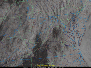
 It's the same story again today, low clouds and occasional showers/drizzle. However, there is some good news--regional visible satellite images show some breaks in the cloud deck over northern VA and along the eastern slopes of the Appalachian Mountains.
Chances of precipitation rapidly decrease tonight as a trough scoops the low clouds out of the region, and we're basically left with a partly sunny day Saturday. As low pressure strengthens off the east coast Saturday night, winds will turn to the northwest and increase to 10-25 mph.
High pressure finally builds in Monday morning, the winds will slacken, and the weather will return to a more settled pattern with fewer clouds and moderating temperatures.
The Weekend Forecast:
With regards to Saturday's high temperature, models do ushering in quite chilly Canadian air, at least in the upper levels over the region. A factor known as compressional heating and downslope airmass modification will be a factor in high temperatures over the weekend. With winds turned around the to the west/northwest, cool air will likely be banked up on the west sides of the mountains, while air riding over the high peaks warm as they slide down the slopes into the Shenandoah Valley, DC area. I was thinking highs Saturday would be near 60-65ish, but it now appears temperatures will generally be in the mid to upper 70s--perfect weekend weather.
Sunday is the day cooler air arrives, as enough cold air rushes down over the mountains to breed high temperatures in the upper 60s to near 70.
A Washington Post article published yesterday outlines the heavy rainfall that has battered parts of the Northeast. Areas like New Hampshire have received incredible amounts of rainfall which has lead to flooding and, unfortunately, three confirmed deaths. Unfortunately, continued light to moderate rainfall is anticipated over parts of New England for the next 36-48 hours. After that, windy conditions and gradual clearing will be a welcome sight for many.


for this post
Leave a Reply