A FROST ADVISORY IS AGAIN IN EFFECT FOR THE ENTIRE METRO REGION AS TEMPERATURES ARE EXPECTED TO FALL INTO THE LOW-MID 30S TONIGHT.
Outlook:
The forecast remains fairly simplistic through the next 3-4 days as strong surface high pressure begins to squeeze its way into the region from the northwest. As the Hp cell continues to build east into the Mid Atlantic, a surface low just east of the NC/SC coast will be shoved far enough away from us to leave us with crisp, sunny, mid-autumn weather over the weekend.
As Sunday rolls around, the surface high and mid level ridge (kind of like a surface high pressure cell in the mid layers of the atmosphere ~20,000 feet) finally catches up to the region, inducing what is known in weather speak as "WAA." Otherwise known as Warm Air Advection, this phenomenan is simply the movement, or ADVECTION, of warmer air into a region. With this said, high temperatures Sunday should finally be able to make it into the upper 60s/near 70.
As we approach Wednesday, however, things get a little trickier. Over the past few days, a potent upper level low has moved east off the northeastern portion of Russia near the province of Magadan, and merged with an equally impressive Aleutian Low (given its name from the predominate location near the Aleutian Islands). Since then, the low has carved out a trough in the northwestern part of the Contiguous United States. By Wednesday, the remnants of this trough are expected to have moved across the extreme northern US-entering our territory on the East Coast.
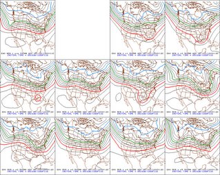
 Models--like the GFS in particular--have had a very rough time forecasting the movements of this trough-ridge-trough pattern that has set up across the United States. For those 'weather fanatics' out there, the image to the right is a plot of several GFS ensemble members valid at 120 hours from 12z this morning (Wednesday morning). Several of them develop a decent trough over the east coast, and at least two of the ensemble members develop a negative tilt of the trough axis (ie: a tilt from the southeast to northwest), which would in turn allow for increased chances of some type of coastal low developing and affecting our region. A less potent trough, on the other hand, would keep precip chances to a minimum-and allow temperatures to remain slight higher than average through the week.
Right now, I like the latter solution given most models support this, and the models that do develop a weaker trough analyzed that trough out west much better.
Image above right: Ensemble members of the Operational GFS from PSU E-Wall
Beautiful Fall Colors:
Okay, since the trees here really aren't changing all that quickly in color, I thought we could use a picture of some truly magnificent fall foliage.
I came across this fantastic and breath-taking image of a forest of fire-red trees at the San Vicino Mountain, taken by Francesco in central Italy. This snapshot reminded me of just how serene and placid late autumn can be-not just in Italy-but here in the Nation's Capital as well.
Tropical Storm Beta is still spinning around in the Caribbean near Nicaragua, where it is expected to make landfall sometime Sunday as a hurricane, possibly eclising the 100mph mark.
Other than Beta, the rest of the Atlantic remains relatively quick, save the normal patchy thunderstorm clusters/tropical waves, although none of these show signs of imminent development.


for this post
Leave a Reply