THE NATIONAL WEATHER SERVICE HAS ISSUED A FLOOD WATCH FOR THE METRO REGION EFFECTIVE 2AM TUESDAY THROUGH TUESDAY PM
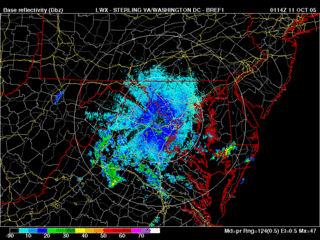
Most locations around the region are reporting either mostly cloudy or completely overcast conditions at the 9:00 hour. Local radar shows scattered areas of light rain showers mainly south and west of a Warrenton to Fredericksburg line. The showers have very gradually been expanding in aerial coverage over the past few hours, and continue to move in a northeasterly fashion, and will likely overspread the DC metro region late tonight and tomorrow.
What's causing this rain now? Well, remember that cold front that ran through the region last weekend with the excess amount of rainfall? It's back. The front stalled over the extreme western Atlantic, and has been forced slowly westward by an upper low to the east. This old frontal boundary in association with another upper level low to the west should combine to form a soggy pattern for the next couple days. Some models are delivering between 1 and 2 inches of rainfall over the next 72 hours or so. Unlike last weekend's event, this rain will not all come in a short period of time, but should be extended over 3 or more days.
Tropical Beat:
Vince has lost most of his punch over the past 24 hours with pretty much all of the thunderstorm activity being ripped off the center of circulation by strong westerly shear. Even though he has lost a lot of his punch, Vince may move into southern Portugal within the next day with some rain showers and gusty winds. You'd probably not even know this was a tropical system.
A vigorous and very large low pressure system is centered near 30N 67W and is associated with a mid-upper level low. Clouds and showers extend over a very wide area, from the central Caribbean Sea, eastward into the Lesser Antilles, and then into the western Atlantic--all associated with this low pressure feature. Development of this system is possible, as it remains nearly stationary over the Atlantic over the next couple of days.


for this post
Leave a Reply