 An absolute drenching has affected the region for the past 36 hours. Some locations in central/western MD have reported rainfall accumulations in excess of 6", with some areas reporting totals approaching 10"! Numerous flood warnings remain in effect until midnight due to runoff from today's rains, mainly affecting the low lying portions of the region.
A very slowly moving cold front is located just east of Washington, DC/Baltimore and continues to inch closer to the Atlantic Ocean. This is effectively shoving the heaviest precipitation east towards the Chesapeake Bay. Even with the front passing, there is enough moisture left in the atmosphere to keep the chances of light showers across the entire region through the night.
Tomorrow, while there will not be nearly as much rain in the region,
clouds will hang tough and backlash from the departing front may promote the development of more isolated showers across the area.
Columbus Day and Tuesday develop a whole host of new problems as a weak wave of spin in the atmosphere ripples northeast into the Mid Atlantic late Monday. At this point, too many details have yet to be worked out, so a small 40% chance of showers is called for Monday Afternoon/Tuesday.
Tropical Talk:
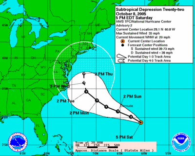
Sub-tropical depression 22 developed earlier today a few hundred miles east or northern Florida. A subtropical depression is basically the same thing as a 'normal' depression (you wouldn't know the difference if you were in one), but also has some characteristics of an extratropical cyclone (a cyclone with no characteristics of a tropical entity).
Sub-TD 22 is moving basically off to the northwest, with a general motion towards the north in 5-6 days as a trough/cold front approach it from the west. At this point, very few affects from this system are expected with a recurvature out to sea, but nearly 5 days separates us from this event getting anywhere near the coast.


for this post
Leave a Reply