Cloudy conditions and occasional drizzle/light showers will be the rule tonight. Dreary weather will continue through Saturday.
Tomorrow, a surface low feature that moved out of the eastern Rockies will approach the region from the west, keeping the chance of scattered rain showers in the forecast through the weekend. Rainfall will likely be the heaviest during Sunday, as the low pressure center makes its closest approach on the region.
The NAM, although notorious for over-forecasting rainfall totals, pumps out in excess of 1" of precipitation through Sunday afternoon.
Wilma Forecast:
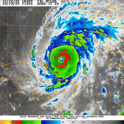
Major Hurricane Wilma continues to churn up the waters in the extreme western Caribbean Sea as a powerful Category 4 system with surface winds estimated near 150 mph. Wilma has a few more hours over the warm waters of the Caribbean before it moves close to the extreme northeastern portion of the Yucatan Peninsula tomorrow afternoon.

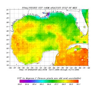
 The Infra-Red satellite image above reveals a large, annular eye attempting to develop right underneath the most powerful convection (otherwise known as the Central Dense Overcast). Oceanic heat content remains very high up until landfall, with sea surface temperature maps revealing a plume of 83*F+ temperatures in no short supply anywhere in the Gulf of Mexico/Caribbean Sea.
One possible problem in the short term with regards to this systems intensity is its current movement. Recently, the center jogged slightly closer to a 360 degree movement (due north). This sudden shift in foreword motion is likely due to a developing mid-latitude trough deepening in the central United States (the same weather feature that will be brining our region the continued chance for rain through the weekend).
Latest NHC advisory maps brought Wilma onshore very near the Playa del Carmen, just southwest of Cancun. However, due to the developing trough to the storms north in the central United States, a more northward track is anticipated, a Wilma will likely graze the easternmost portions of the Yucatan--but should not actually make landfall in the said area. However, it must be stressed that even with a track a bit farther east, this system will doubtlessly cause catastrophic damage to portions of the Yucatan over the next 36-48 hours.
Possible effects from Wilma later next week:
There is still a large amount of model spread with regards to the impacts (if any) Wilma has on the region's weather next week. The wildly oscillating GFS now seems to be emphatic on keeping Wilma far enough away from the coast to prevent the region from seeing much more than some breezy weather, and some spotty showers next week. The model keeps whisks Wilma out to sea as a powerful trough digs into the eastern US early next week. This trough acts like a brick wall, and keeps any low pressure system to the east from moving west into the Mid Atlantic.
However, there are still models that show a partial phase of this monster hurricane next Monday/Tuesday, and this scenario cannot be ruled out. Such a forecast would bring Wilma closer to the coast, yielding more rainfall, and gusty winds from the powerful low.
Nasa's Hurricane Animation:
And while on the topic of tropical weather, NASA has published an animation of all the tropical systems in the Atlantic starting on June 1st, 2005. ***Warning*** This is a large 20MB file that took about 30 seconds to download on my high speed connection. Dial-up users could experience long download times.


for this post
Leave a Reply