| Days | Mon | Tue | Wed | Thu | Fri | Sat | Sun |
|---|---|---|---|---|---|---|---|
| Lee C. | -- | -- | -- | -- | -- | -- | -- |
| John Y. | -- | -- | -- | -- | -- | -- | -- |
| Days | Mon | Tue | Wed | Thu | Fri | Sat | Sun |
|---|---|---|---|---|---|---|---|
| Temps | -- | -- | -- | -- | -- | -- | -- |
Cool weather to reign supreme next few days
Expect sunny conditions tomorrow with highs struggling to make it into the 70s.
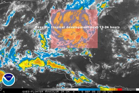
We still don't have a tropical depression in the Caribbean which kind of surprises me given the favorable conditions for development, but the airforce reserve aircraft that was out there earlier today has come back saying the system remains poorly organized. Nonetheless, conditions remain relatively favorable for development over the next couple of days as it drifts to the northwest at 10 mph.
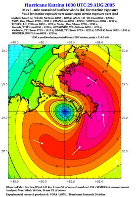
Speaking of the tropics, I stumbled across some interesting graphics today from Eastern US Weather Forums taken from the SFMR (Stepped Frequency Microwave Radiometer), more info can be found here, inland observations, and NHC landfall products.
This system is still "experimental" and has consistentlty under-analyzed surface winds (you can probably tell, because 100kts is 115mph, and many surface reports at the time of landfall were near 120 mph before the observation systems failed). Once the kinks have been worked out of this system, this will likely be a great addition to the NHC aresenal.
Afternoon Update
Saturday looks perfect with highs near 70, light winds, and little cloud cover. However, the pattern we're in at this time forces the cool high's east fairly quickly, so we begin another warming trend Sunday as the high pressure moves east.
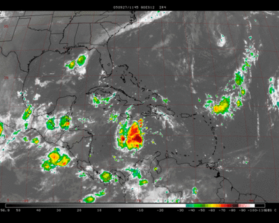
The tropical low in the Caribbean has been trying to get organized over the past 24 hours, and has recently shown an increase in thunderstorm activity around its center of circulation. Upper level conditions are become more conducive for development...and I still expect this system to become our next tropical depression as it drifts northwestward.
Gorgeous Early-Autumn
Wednesday gets a little warmer as winds swing around to the south with the approach of a strong cold front. Expect clouds to thicken quickly through the night Wednesday and into Thursday morning. Showers should break out across the western portions of MD/WV overnight Wednesday/Thursday AM and progress eastward with time, reaching the DC area in the early/mid morning hours. At this point, the severe weather threat looks minimal as very little sunshine will be available to add any instability to the atmosphere. Still, a few embedded thunderstorms are possible with the passage of this front.
Low temps Thursday night may even dip into the 40s in the metro region as a strong Canadian High moves into the Mid Atlantic/Northeast. The great conditions last through the weekend with high temperatures Saturday only near 70!
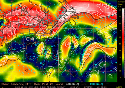
And about that wave in the Caribbean Sea...it's still there and getting organized fairly quickly. Data from the CIMSS (Cooperative Institute for Meteorological Satellite Studies) shows wind shear over the system slackening with a little less than 10kts (about 15mph) of shear affecting the disturbance. On top of this, water temperatures are very high, approaching 90F in isolated areas.
Wind Shear map showing light winds over the central Caribbean
With this said, I expect our next tropical depression to form within 36 hours in the central Caribbean. Models are spread out, with some taking this system into the Gulf of Mexico, and others splitting it off to the northeast. New data in the next few days will help pinpoint where this disturbance heads.
Rain's outta hear tomorrow


Left: MD Radar image showing scattered showers slowly approaching the region from the west
Right: NAM model forecast valid tonight as a cold front speeds through the region
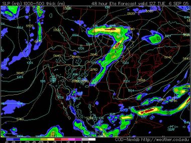
The nice conditions don't last long as the high pressure speeds away Thursday with the approach of yet another cool front-this one more powerful than the one going through tonight. The NAM model has shifted the low associated with the cold front much farther north than in previous runs, reducing our chances of seeing any appreciable rainfall.
Behind the front is another cold high pressure dome, which may usher in the coolest temperatures of the season, with highs on Friday struggling to get out of the 60s/low 70s.
Oh, and if we needed another tropical system to watch...the National Hurricane Center is keeping a close eye on an area of disturbed weather in the Caribbean Sea that shows signs of slow organization. What's even more disturbing is most operational guidance models track this disturbance into the Gulf of Mexico in a little less than a week from now. Sea Surface Temperatures are incredibly high in this area (exceeding 90F in some locations), and conditions look to become more favorable for development over the next few days.
Monday Update
While the showers from this frontal passage may drop a quarter to half an inch of rainfall on the region, it won't be enough to make much of a difference in the rainfall deficit.
The next chance for (a possibly) more significant rain-event moves into the area during the day Thursday. There is some model discrepancy (as can be expected at three days out), with the GFS model pushing the cold front through early Thursday, with the NAM (formerly the ETA) holding it back until Thursday evening.
Also, depending on the amount of sunshine we see Thursday, we may have a small chance of some convection bubbling up (assuming the NAM model is correct), due to the strong low level jet over the Mid Atlantic in excess of 30kts at about 15,000 feet. This then increases to near 100kts at 20,000 feet or so, which displays a large amount of speed shear is present in the atmosphere. Speed shear is simply the change of wind speed with height--the higher the winds in the upper levels of the atmosphere, the stronger the wind shear. This helps sustain thunderstorm updrafts and is one key element forecasters look for in severe weather situations.
Granted, I can't see a large severe weather event for Thursday afternoon at this time--while the extreme wind shear is conducive for strong thunderstorms, there doesn't seem to be enough instability to initiate severe storms.
There is one thing I am certain about, though, and that is a cold Canadian High Pressure system will slide in behind the aforementioned cold front and deliver some "chilly" air to the region. Some models show low temperatures Friday morning dipping into the 30s out west in the mountains, and into the upper 40s-lower 50s near the metropolitan centers.
It would seem that autumn really has arrived...
Weather remains uneventful in DC
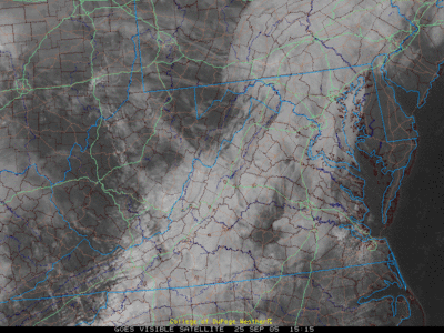
As for the fate of dwindling Rita, some computer models are still re-introducing her into the Gulf of Mexico next week, but the consensus seems to have shifted for more of a northeasterly track over Tennessee and Kentucky and the Ohio River valley, as she is absorbed by an approaching cold front in the coming days.
Even with Hurricane Rita making landfall over 200 miles to the west, Louisiana still felt the effects of water being piled up near the now famous 9th-ward. Once again, water was pushed over the severely jeopardized levees from Katrina's wrath nearly a month ago, flooding the recently dried streets.
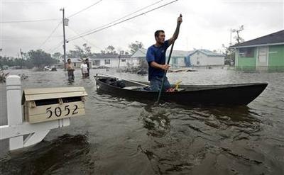
Kyle Guidry paddles up a street in Laffite, La., to check on his house after surges from Hurricane Rita flooded the area on Saturday.
As she approached land, the continental shelf rises and water depths decrease dramatically. Hence, the depth of 80F water decreases closer to shore. And another reason for Rita's weakening from the amazing category 5 she was out in the Gulf was due in part to a long-lasting eyewall replacement cycle, that is always expected in very powerful hurricanes. Storms of this magnitude simply cannot sustain wind speeds like 170mph for an extended period of time, so the central eyewall contracts while a larger outer-eyewall tightens.
This cycle lasted for a very long period of time, much longer than usual, so Rita had no time to re-strengthen into the category 4 that was expected about 36-48 hours prior to landfall.
Whatever the case is though, Rita still wreaked destruction on eastern Texas and Louisiana, and was the second major hurricane to hit the US in less than a month.
Less than perfect weekend weather
On Monday, a cold front begins to approach the region from the west, turning our winds to the southwest and advecting slightly warmer temperatures into the area. By Monday night, some showers may begin breaking out across western Maryland, eventually spreading into the DC metro region overnight. The cold front wont really do anything to lower temperatures, but it will deliver some much needed rainfall. For the month of September, Washington is nearly 3" below normal with regards to rainfall, while BWI is around 2.5" below normal. I don't anticipate rainfall totals from the passage of the aforementioned cold front to amount to anything more than .5"
Wednesday and Wednesday night, high pressure moves east of the region to make way for a relatively powerful low pressure system diving southeastward out of Ontario. Thursday it's associated cold front rips through the Mid Atlantic ushering the first real "Autumn-like" temperatures. As the heights lowers in the atmosphere, a Canadian high pressure system glides in behind the strengthening low on Friday. Overnight lows may dip into the 50s in the metropolitan centers, and into the 40s out west.
As former Hurricane Rita degenerates into a tropical depression, she is expected to become a rain maker, spreading upwards of a foot of rain into the ARKLATEX region over the next 48 to 84 hours. Where she goes after that is a question. Some models absorb her into the cold front (mentioned above) on Tuesday. Still other models let her drift in the southern states for a few days--with at least 3 separate models driving Rita back into the Gulf of Mexico in 5 to 6 days.
And if Rita wasn't enough, the NHC is watching two more systems that have the potential to develop into tropical depression in the next couple of days. The first system is an area of low pressure associated with the remnants of Philippe. Even if this system redevelops, it will only be a concern to shipping interests.
Rita Makes landfall-Weakening anticipated
A significant rainfall threat will persists in Texas/Louisiana well into the weekend as Rita looses interaction with upper level steering currents. Rita's foreword movement should slow to around 5mph and move in an erratic pattern to the north, the northeast, across northeastern Texas, southern Arkansas and northern Louisiana. With this slow movement, Rita will be able to drop copious amounts of rainfall along the ARKLATEX region--possibly approaching 1 to 2 feet in some locations.
It looks like Rita will eventually get absorbed into a cold front by Monday as it swings in from the northwest. Another Scenario is for Rita to make a loop around Louisiana and re-enter the Gulf of Mexico in about 5 days, as shown by the GFDL, and all three of the Beta and Advection (BAMS, BAMM, BAMD) models.
Isolated small tornadoes will remain a possibility east of the center of circulation in Louisiana pretty much through the day. Tornadoes associated with landfall hurricanes are usually weak (F0-F2) but can still cause significant damage. For this reason, the Storm Prediction Center in Norman, OK has issued a tornado watch for all of Louisiana and southern Alabama until 500PM CDT.
Outlook:
Mostly cloudy to overcast conditions will persist through the day and night across the region as high pressure in Ontario funnels low level moisture into the Mid Atlantic. Don't expect too much in the way of precipitation today, but some drizzle/showers will be possible.
Highs today will not be nearly as warm as yesterday, when Washington, Dulles International Airport reported a high of 93F, breaking the previous 35 year record of 92F. Expect temperatures to remain in the 70s today under the cloudy conditions.
Get ready for the worst
Rita continues to re-organize over the warm waters of the western Gulf of Mexico with the eye beginning to become more concentric/circular with time. A very large batch of intense convection and cold cloud tops (<-70C) is visible on the western Flank of Rita's eyewall with the northern outflow expanding due to friction against land (Louisiana/Arkansas).
Landfall still looks to occurr early Saturday morning between the TX/LA boarder and the Galveston area. My guess is maximum sustained winds at that time may be somewhere around 130 to 145 mph.
UPDATE: 500 PM EDT
After a lapse in intensity this afternoon, Hurricane Rita appears to be organizing her structure again. IR and Visible Satellite loops reveal good outflow around the entire system, especially to the north where high cirrus clouds associated with Rita extend into Arkansas. Regional Sea Surface Temperature maps reveal a pool of 29+ degree Celsius water just off the eastern Texas Coastline (near 86F). And to give you a broad idea of how high 30C water is, Rita's extreme deepening two days ago occurred over water ranging between 80 and 84F.
Landfall looks to occurr within the next 14-18 hours anywhere from the TX/LA Boarder southwestward into the Galveston Bay area. But remember, tropical storm force winds extend over 150 miles either end of the center of Rita, and hurricane force winds in a 50 mile radius. The damage swath of Rita will be large and damage will be severe. Anyone staying behind should not venture outside tonight or tomorrow.
Hurricane Rita remains a potentially catastrophic Category 4 hurricane with maximum sustained winds near 140mph. Rita has not completed her eyewall replacement cycle that was started the other day. Her eyewall remains ragged and the outflow to the west has been broken down a bit, probably due to some westerly shear.
Rita remains over an area of relatively high sea surface content--with sea surface temperatures near 82-88F. With this said, once Rita completes her eyewall replacement cycle (probably within the next 6 hours or so), she will be over some very favorable waters for more strengthening before landfall.

On top of this, if you look closely, there are SST's near 90F right along the northeastern Texas Coastline. A major problem with the strength forecast of Rita at landfall is complicated by the fact that the depth of the warm waters decreases the closer she gets to Galveston/western LA. And as we saw with Katrina--weakening of strong hurricanes upon landfall is a frequent occurrence. But with all this aside--expect Rita to move onshore near the Galveston/Beaumont area Saturday morning as a major category 4 hurricane (slight chance it's a 5) with winds between 130 and 150 mph.
Satellite Image showing Hurricane Rita's ragged looking appearance--but still is powerful
Rita's the center of attention
Take this storm seriously, it has the potential to devestate northeastern Texas and western Lousiana.
Hurricane Rita Continues to churn in the Gulf
This is absolutely incredible! It's now official; Rita is the 3rd strongest hurricane on record in the Atlantic basin. Here is the snippet from the NHC website:
...RITA BECOMES THE THIRD MOST INTENSE HURRICANE ON RECORD...
DROPSONDE DATA FROM AN AIR FORCE RESERVE UNIT RECONNAISSANCE
AIRCRAFT AT 623 PM CDT...2323Z...INDICATED THE CENTRAL PRESSURE HAS
FALLEN TO BELOW 899 MB...OR 26.55 INCHES. THE DROPSONDE INSTRUMENT
MEASURED 32 KT/35 MPH WINDS AT THE SURFACE...WHICH MEANS IT LIKELY
DID NOT RECORD THE LOWEST PRESSURE IN THE EYE OF RITA. THE CENTRAL
PRESSURE IS PROBABLY AT LEAST AS LOW AS 898 MB...AND PERHAPS EVEN
LOWER. FOR OFFICIAL PURPOSES... A PRESSURE OF 898 MB IS ASSUMED...
WHICH NOW MAKES RITA THE THIRD MOST INTENSE HURRICANE IN TERMS OF
PRESSURE IN THE ATLANTIC BASIN. SOME ADDITIONAL DEEPENING AND
INTENSIFICATION IS POSSIBLE FOR THE NEXT 12 HOURS OR SO.
RITA CURRENTLY RANKS BEHIND HURRICANE GILBERT IN 1988 WITH 888 MB
AND THE 1935 LABOR DAY HURRICANE WITH 892 MB.
Update:
As of 5PM Hurricane Rita has attained Category 5 status with maximum sustained winds approaching 170mph. Her central pressure has fallen to 904mb, making Rita the fifth strongest hurricane on record in terms of pressure in the Atlantic Basin.
Rita has been tracking over the warm waters of the Gulf of Mexico, and as a result has strengthened significantly into a category 4 hurricane with maximum sustained winds around 135mph. Rita continues to develop a very well defined eye and improve in its overall structure.
There is also very good model support for a landfall near the Galveston, TX area sometime on Saturday. It also appears Rita will move onshore with at least category 3 strength winds--possibly higher--and anyone living in the western Gulf Coast should begin to take action today and tomorrow.
Watch out eastern Texas


As for the weather in our area, a cold front and pre-frontal trough continue to progress eastward setting off some intense showers and thunderstorms along the eastern shore and lower southern Maryland. The Storms Prediction center has issued a severe thunderstorm watch for portions of eastern Virginia, northern NC, and extreme southern Maryland until 900PM tonight. Although widespread severe weather is not anticipated, isolated severe storms will be possible in the aforementioned areas with small hail (<1" in diameter) and some wind gusts exceeding 60mph.
The front will pass later tonight giving way to mostly sunny conditions comfortable temperatures in the lower 80s before our attention turns to another cold front/trough late in the week with some showers and much cooler conditions, with lows possibly dipping into the 50s and 40s out west this weekend.
Rita Now a Hurricane, Lashing the Keys
Radar from the Keys shows Rita's eye about 100 miles southeast of Marathon and Key West. Winds were gusting to 60mph at last check, and they will only increase through the day.
A Tornado watch is also in effect for all of Florida south of Lake Okeechobee until 500PM. As the thunderstorms associated with Rita move onshore, the friction and rotation of the cloud mass develops a favorable setup for at least weak F0 tornadoes in the outlined area.
For us, the weather should remain relatively tranquil with a few showers developing north and west of the region associated with a weak cold front well west of the area. Expect about a 30% chance of showers/thunderstorms today in the metro area, and a 50 or 60% chance west in the Shennandoah Valley area/western Maryland.
Tropics ready to go
And on a more important note, Tropical Storm Rita is sitting in the southern Bahamas and looks to become a hurricane later tonight or tomorrow. Hurricane warnings are in effect for southern Florida and Grand Bahama Island, and hurricane watches extend along the western side of Cuba.


GFDL Model forecast showing Rita making landfall in southern LA as a CAT 2 Hurricane
Philippe strengthens as Ophelia fades away
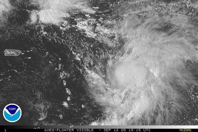
Visible Satellite image of Tropical Storm Philippe
On top of this, Tropical Depression 18 has also developed in the southern Bahamas. It continues to organize rapidly and should become a tropical storm (Rita) later tonight or tomorrow. TD-18 is forecast to move into the Gulf of Mexico and may eventually become a hurricane. The Bahamas, southeastern Florida, and northern Cuba will be effected by this tropical disturbance over the next few days.
Anyone living along the western Gulf Coast should keep a close eye on TD-18 over the next 5-7 days.
Hurricane Ophelia has eyes set on NC
Morehead City doppler radar rainfall estimates are approaching 1 foot in some regions of extreme southeastern North Carolina. Heavy rainfall and a very slight risk of an isolated tornado embedded in individual squalls will persist for the next 12 hours at least n NC.
After moving past the 35th parallel, Ophelia should begin to accelerate quickly to the northeast as a she gets absorbed into a vigorous mid level trof (surface cold front) approaching from the west.
Weather across the Mid Atlantic shouldn't be affected too much by Ophelia. Areas near the eastern shore and east of the I-95 corridor have the best chance of seeing some precipitation.
All eyes on Ophelia
Over the past few hours, Ophelia (now a hurricane as of 5PM) has continued to become better organized with a central dense overcast trying to form around the storms center of circulation.
Radar imagery from the Wilmington, NC National Weather Service Doppler radar depicts the outer rainbands associated with Ophelia spreading inland, albeit extremely slowly. Given the slow movement of this system, there is concern Ophelia could dump in excess of 5-8" of rain in some locations through Thursday.
Winds with this system are not expected to be a major problem and should generally stay under 90-100mph, limiting the amount of damage from that field. However, tornadoes and a few severe thunderstorms may pose an isolated risk for increased storm damage, mainly closer to the SC/NC coastline.
Ophelia will eventually move out of the picture as a mid-latitude cold front approaches from the west and helps to "kick" her out into the north central Atlantic. With this track, the extreme southeastern Canadian Maritimes may feel some affects from a weakening Hurricane Ophelia.
As for Ophelia's affects on our weather, they look to remain rather minimal as the Category 1 hurricane should remain well south and east of the metro region. Some increased cloudiness and a few showers (mainly associated with the aforementioned cold front) should be the only noticeable effects around the metro region Wednesday night/Thursday.
O is for 'Ophelia'
Through the beginning of next week, the surface high pressure that has been yielding the all the nice conditions over the past few days will begin to degrade as it moves off the east coast. The next chance of any precipitation will come in during the middle parts of next week
Hurricane Ophelia has been moving erratically over the past week being steered by rather weak mid and upper levels winds. At the moment, Ophelia is a minimal category 1 hurricane with winds near 80 mph. She is a large storm with very little foreward movement at the present time.
There is still a significant amount of uncertainty regarding Ophelia's future track, but it seems she will make landfall along the southeast coast as a category 1 and maybe even a category 2 hurricane.

Folks living along the North Carolina/South Carolina area should stay abreast on the developing situation. While winds are not anticipated to be greater than 111mph (Major hurricane strength) squalls with winds in excess of 100mph will be possible upon Ophelia's landfall sometime Monday afternoon/evening.
Tropics Ramping up...Again
Tropical Storm Nate formed late last night about 250 miles southwest of Bermuda and now has maximum sustained winds near 60 mph, approaching hurricane force. Nate is expected to become embedded in a mid level trough later this week and should be swept away to the east, maintaining a good distance from the American mainland. Nate is expected to become a hurricane later tonight or tomorrow.
And finally, tropical depression 16 formed about 200 miles east of Cape Canaveral, Florida late this morning. The depression is currently poorly organized with clusters of showers/thunderstorms loosely packed around the low level circulation.
TD-16 is expected to become a tropical storm within the next 12-36 hours, and for that reason, a tropical storm warning has been hoisted from Jupiter, FL to Titusville, FL. Rainfall totals form this system may exceed 5" in some locations over the next week. While this system isn't expected to bring significant winds to eastern Florida, significant rain and flash flooding will be of significant concern as TD-16 (Ophelia when/if named) moves slowly northwestward.
Yet another Tropical Depression?
Latest Visible satellite imagery indicates the system is developing a good amount of convection right around the low level center of circulation with some very cold clous tops (near -75C) embedded around the low pressure.
The graphic below is the National Hurricane Center's 5-day outlook for the eventual track of Td-15. Notice the large bend the storm makes to the east in 3-4 days as a mid-level trough approaches from the west.
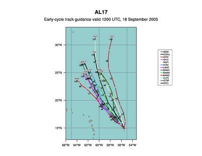
There is significant spread in tropical models due to the very weak steering currents throughout the enitre atmosphere with upwards of a 500 mile difference between the Beta and Advection Models (BAM).
Evening Update
Not much to talk about in the weather department over the next 5 days for the entire Mid Atlantic region as a cool Canadian high pressure center drifts eastward across the northern United States. Expect high temperature through the week to range from the upper 70s to low 80s pretty much across the board with full sunshine and light winds.
Temperatures during the evening may even dip into the upper 50s to near 60 on Tuesday/Wednesday morning as high pressure slides right over the DC metro area.
New Orleans Editorial rips FEMA a good one--the The Times-Picayune of New Orleans printed an editorial and open letter to the President criticizing (and that may be an understatement) the government's response to a disaster everyone knew was coming. The letter, printed in full (from CNN):
And even I can say, the way the government handled this disaster was completely unacceptable. Scientists and researchers had outlined the potential for complete destruction of New Orleans years in advance, and procedures were developed on how to evacuate the people from the city, get food and water to the needy, etc, and yet, the whole process was fumbled into an absolute mess.Dear Mr. President:
We heard you loud and clear Friday when you visited our devastated city and the Gulf Coast and said, "What is not working, we're going to make it right."
Please forgive us if we wait to see proof of your promise before believing you. But we have good reason for our skepticism.
Bienville built New Orleans where he built it for one main reason: It's accessible. The city between the Mississippi River and Lake Pontchartrain was easy to reach in 1718.
How much easier it is to access in 2005 now that there are interstates and bridges, airports and helipads, cruise ships, barges, buses and diesel-powered trucks.
Despite the city's multiple points of entry, our nation's bureaucrats spent days after last week's hurricane wringing their hands, lamenting the fact that they could neither rescue the city's stranded victims nor bring them food, water and medical supplies.
Meanwhile there were journalists, including some who work for The Times-Picayune, going in and out of the city via the Crescent City Connection. On Thursday morning, that crew saw a caravan of 13 Wal-Mart tractor trailers headed into town to bring food, water and supplies to a dying city.
Television reporters were doing live reports from downtown New Orleans streets. Harry Connick Jr. brought in some aid Thursday, and his efforts were the focus of a "Today" show story Friday morning.
Yet, the people trained to protect our nation, the people whose job it is to quickly bring in aid were absent. Those who should have been deploying troops were singing a sad song about how our city was impossible to reach.
We're angry, Mr. President, and we'll be angry long after our beloved city and surrounding parishes have been pumped dry. Our people deserved rescuing. Many who could have been were not. That's to the government's shame.
Mayor Ray Nagin did the right thing Sunday when he allowed those with no other alternative to seek shelter from the storm inside the Louisiana Superdome. We still don't know what the death toll is, but one thing is certain: Had the Superdome not been opened, the city's death toll would have been higher. The toll may even have been exponentially higher.
It was clear to us by late morning Monday that many people inside the Superdome would not be returning home. It should have been clear to our government, Mr. President. So why weren't they evacuated out of the city immediately? We learned seven years ago, when Hurricane Georges threatened, that the Dome isn't suitable as a long-term shelter. So what did state and national officials think would happen to tens of thousands of people trapped inside with no air conditioning, overflowing toilets and dwindling amounts of food, water and other essentials?
State Rep. Karen Carter was right Friday when she said the city didn't have but two urgent needs: "Buses! And gas!" Every official at the Federal Emergency Management Agency should be fired, Director Michael Brown especially.
In a nationally televised interview Thursday night, he said his agency hadn't known until that day that thousands of storm victims were stranded at the Ernest N. Morial Convention Center. He gave another nationally televised interview the next morning and said, "We've provided food to the people at the Convention Center so that they've gotten at least one, if not two meals, every single day."
Lies don't get more bald-faced than that, Mr. President.
Yet, when you met with Mr. Brown Friday morning, you told him, "You're doing a heck of a job."
That's unbelievable.
There were thousands of people at the Convention Center because the riverfront is high ground. The fact that so many people had reached there on foot is proof that rescue vehicles could have gotten there, too.
We, who are from New Orleans, are no less American than those who live on the Great Plains or along the Atlantic Seaboard. We're no less important than those from the Pacific Northwest or Appalachia. Our people deserved to be rescued.
No expense should have been spared. No excuses should have been voiced. Especially not one as preposterous as the claim that New Orleans couldn't be reached.
Mr. President, we sincerely hope you fulfill your promise to make our beloved communities work right once again.
When you do, we will be the first to applaud.
There is concern another tropical disturbance could affect the Florida panhandle later in the week as outlined in the National Hurricane Center's Tropical weather Outlook:
All of the Beta and Advection Models (BAM) bring this area of disturbed weather into east central Florida within the next 24-36 hours and eventually into the northern Gulf of Mexico. The below graphic displays Hurricane Maria in the central Atlantic (no threat to land) and the area of disturbed weather about 100-200 miles off the eastern Florida panhandle. While this system is not expected to bring high winds to Florida, special attention must be paid to this tropical system over the next few days as it works across Florida and into the Gulf. Another hit from any hurricane (be it a category 1 or a category 5) along the Gulf Coast would bring catastrophic problems to our economy.FOR THE NORTH ATLANTIC...CARIBBEAN SEA AND THE GULF OF MEXICO...
THE NATIONAL HURRICANE CENTER IS ISSUING ADVISORIES ON HURRICANE
MARIA... LOCATED ABOUT 530 MILES EAST-SOUTHEAST OF BERMUDA.
AN AREA OF LOW PRESSURE CENTERED ABOUT 330 MILES SOUTH OF BERMUDA IS
DRIFTING NORTHWARD. ALTHOUGH THE ASSOCIATED SHOWER ACTIVITY IS
STILL NOT WELL ORGANIZED AROUND THE CENTER... CONDITIONS APPEAR
FAVORABLE FOR THIS SYSTEM TO DEVELOP INTO A TROPICAL DEPRESSION
DURING THE NEXT DAY OR SO.
SURFACE OBSERVATIONS AND SATELLITE IMAGERY SUGGEST THAT A BROAD
SURFACE LOW PRESSURE SYSTEM COULD BE DEVELOPING JUST OFF THE
SOUTHEASTERN COAST OF FLORIDA AND OVER THE NORTHWESTERN BAHAMAS.
THE ASSOCIATED SHOWER ACTIVITY HAS BECOME A LITTLE MORE
CONCENTRATED TODAY... AND UPPER-LEVEL WINDS ARE SOMEWHAT FAVORABLE
FOR ADDITIONAL AND GRADUAL DEVELOPMENT. IT IS POSSIBLE THAT THIS
NEARLY STATIONARY SYSTEM COULD DEVELOP INTO A TROPICAL DEPRESSION
DURING THE NEXT DAY OR SO.
SHOWER ACTIVITY REMAINS LIMITED IN ASSOCIATION WITH THE
WESTWARD-MOVING TROPICAL WAVE LOCATED ABOUT 550 MILES EAST OF THE
LESSER ANTILLES. SIGNIFICANT DEVELOPMENT OF THIS SYSTEM IS NOT
EXPECTED OVER THE NEXT COUPLE OF DAYS.
THE REMNANT CIRCULATION OF TROPICAL DEPRESSION LEE IS MERGING WITH A
FRONTAL ZONE ABOUT 475 MILES SOUTH-SOUTHEAST OF CAPE RACE
NEWFOUNDLAND.
ELSEWHERE...TROPICAL STORM FORMATION IS NOT EXPECTED THROUGH
MONDAY.
It is far too early to speculate about this tropical low's eventual path once it enters the Gulf of Mexico in 3 days or so, but residents along the northern Gulf coast and southern Florida are urged to watch the development of this system very closely.
Sweet Weekend Forecast and Recovering in the South
Weather in the DC area can be summed up fairly quickly with highs near 80 and lows dipping into the upper 60s to near 70 pretty much through next week! There will likely be very little worth-while to talk about weather wise in the Mid Atlantic region for the next few days as the high slowly creeps along to the east.
Yet another Tropical Storm forms in the central Atlantic Ocean the 13th named storm of the season (Maria), and we've barely started September. This month is climatologically the most active portion of the Atlantic Hurricane Season with 2-5 named systems developing within the month. Maria doesn't look all that great on satellite with sporadic bursts of convection around its assumed center of circulation.
Don't expect Maria to be any threat to land, with the only impacts being to mariners in the central Atlantic Ocean.
Relief efforts finally showing up in New Orleans after being all but absent from the city for the past 4 days. Some are thinking this may be too little, too late for the devastated community of Louisiana, but at least help is there.
Source: CNN/AP Photos
The National Guard and other Agencies like FEMA have been pouring into the city through the evening hours beginning what will be an excruciatingly long and tiring recovery process.
Grim Scenario in New Orleans
Left: New Orleans Residents attempting to get on a bus headed out of the city towards Texas. Right: Congregation of people outside the Superdome where conditions are becoming increasingly dire.
Source: CNN
A Desperate Situation along the Northern Gulf Coast
With the news from the Crescent City becoming bleaker as the days wear on, the situation has gotten even worse. As evacuees fled the city on Buses bound for the Astrodome, the evacuation attempts of the New Orleans Charity Hospital were halted after it came under gun fire this afternoon.
To add onto all of this, thousands upon thousands of stranded individuals in the city are entering (potentially at least) there 5th day without food and/or water since the onset of Hurricane Force winds late Sunday night. Reports of people just collapsing on the streets due to dehydration have already rolled in. Brawls and trash fires have been springing up at the Superdome where some 20,000 refugees are hold up waiting to be evacuated out of the region. This snippet of an article posted on CNN's website pretty much says it all:
"We are out here like pure animals. We don't have help," the Rev. Issac Clark, 68, said outside the New Orleans Convention Center, where corpses lay in the open and evacuees complained that they were dropped off and given nothing.
And what's worse--what we are seeing may only be the beginning
With concerns about looters, dehydration, and health risks, the scene (even though unsettling to say the least) may become even more disturbing as the days, weeks, and eventually, months drag on. No running water, electricity, or working sewers exist in the city, or along any of the areas hit by Katrina. People are in close proximity to one another as they attempt to find a way out of the city, or in the Superdome. Dr. Michael Osterholm mentioned the following in a news article published on the internet
"When you get that many people together under those conditions, just one person who's infected could infect many other un-vaccinated people."
Food-borne outbreaks such as E. coli and transmittable respiratory illnesses are also a threat, he said.
Tornadoes touch down in VA
The National Weather Service surveyed the damage from a weak tornado that touched down on Tuesday evening associated with the remnants of Katrina. The weak, F0 Tornado touched down in Fauquire county near Orlean with an average path width of 75 yards.
Another stronger, F1 touched down near Marshall, VA with winds approaching 100mph. The base width was significantly larger than the F0 at 300 yards or so.

