

Hurricane Maria over the Central Atlantic with max winds of 100mph
Tropical Storm Nate formed late last night about 250 miles southwest of Bermuda and now has maximum sustained winds near 60 mph, approaching hurricane force. Nate is expected to become embedded in a mid level trough later this week and should be swept away to the east, maintaining a good distance from the American mainland. Nate is expected to become a hurricane later tonight or tomorrow.
And finally, tropical depression 16 formed about 200 miles east of Cape Canaveral, Florida late this morning. The depression is currently poorly organized with clusters of showers/thunderstorms loosely packed around the low level circulation.
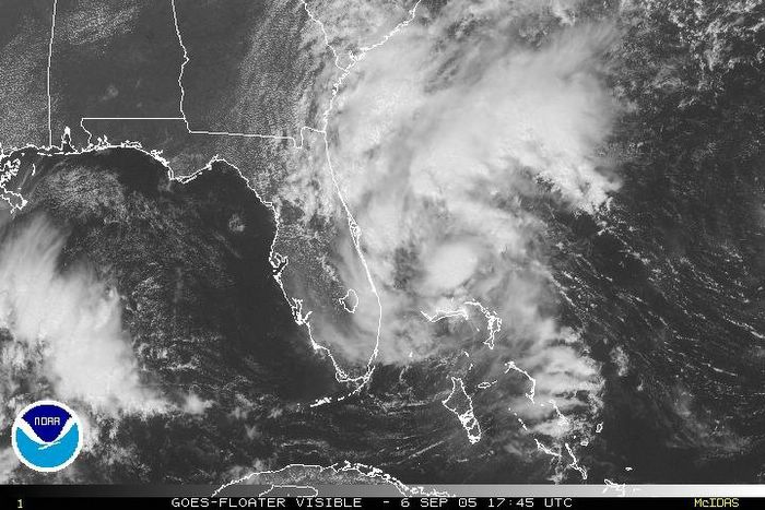
Tropical depression 16 over the northern Bahamas
Latest model products move TD-16 in a more northwesterly direction than noted yesterday, when all of the BAM models took it over central FL and into the Gulf of Mexico late this week. There is now a slightly more clustered forecast for this system to slowly travel northwestward, almost paralleling the eastern Florida coast for the next few days, and may eventually slide into the northern Gulf of Mexico, but details still have a long way to be worked out.
TD-16 is expected to become a tropical storm within the next 12-36 hours, and for that reason, a tropical storm warning has been hoisted from Jupiter, FL to Titusville, FL. Rainfall totals form this system may exceed 5" in some locations over the next week. While this system isn't expected to bring significant winds to eastern Florida, significant rain and flash flooding will be of significant concern as TD-16 (Ophelia when/if named) moves slowly northwestward.
TD-16 is expected to become a tropical storm within the next 12-36 hours, and for that reason, a tropical storm warning has been hoisted from Jupiter, FL to Titusville, FL. Rainfall totals form this system may exceed 5" in some locations over the next week. While this system isn't expected to bring significant winds to eastern Florida, significant rain and flash flooding will be of significant concern as TD-16 (Ophelia when/if named) moves slowly northwestward.


for this post
Leave a Reply