A cold front screamed through the region around 10AM this morning accompanied by wind gusts in excess of 50 mph in some locations out west, not from severe thunderstorms, but from the front transferring high winds down from about 10,000 feet. As a consequence (although maybe not for some) of the frontal passage, the National Weather Service has issued A FROST ADVISORY for Western MD, western PA, and into WV. Low temperatures are expected to dip into the low 30s under clear skies and diminishing winds.
Expect sunny conditions tomorrow with highs struggling to make it into the 70s.
We still don't have a tropical depression in the Caribbean which kind of surprises me given the favorable conditions for development, but the airforce reserve aircraft that was out there earlier today has come back saying the system remains poorly organized. Nonetheless, conditions remain relatively favorable for development over the next couple of days as it drifts to the northwest at 10 mph.
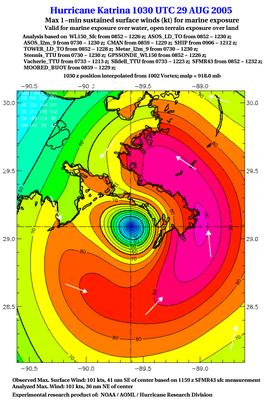
Speaking of the tropics, I stumbled across some interesting graphics today from Eastern US Weather Forums taken from the SFMR (Stepped Frequency Microwave Radiometer), more info can be found here, inland observations, and NHC landfall products.
This system is still "experimental" and has consistentlty under-analyzed surface winds (you can probably tell, because 100kts is 115mph, and many surface reports at the time of landfall were near 120 mph before the observation systems failed). Once the kinks have been worked out of this system, this will likely be a great addition to the NHC aresenal.
| Days | Mon | Tue | Wed | Thu | Fri | Sat | Sun |
|---|---|---|---|---|---|---|---|
| Lee C. | -- | -- | -- | -- | -- | -- | -- |
| John Y. | -- | -- | -- | -- | -- | -- | -- |
| Days | Mon | Tue | Wed | Thu | Fri | Sat | Sun |
|---|---|---|---|---|---|---|---|
| Temps | -- | -- | -- | -- | -- | -- | -- |
Cool weather to reign supreme next few days
By Lee Carlaw On Thursday, September 29, 2005 At 4:58 PM


for this post
Leave a Reply