Local Forecast
Weather Wars: 7 Day Forecast Battle
Days Mon Tue Wed Thu Fri Sat Sun
Lee C. -- -- -- -- -- -- --
John Y. -- -- -- -- -- -- --
Temperature Verification
Days Mon Tue Wed Thu Fri Sat Sun
Temps -- -- -- -- -- -- --
|

Tropical Depression 3 Formed...

UPDATE: Tropical depression 3 was upgraded to Tropical Storm status; Chantal is not a threat to the United States but may cause minor damage in eastern Newfoundland.

The NHC announced this evening that the disturbance just west of Burmuda had gained enough strength to warrant being named a tropical depression.

This storm has no chance of making US landfall, but may become a weak tropical storm before becoming extropical and absorbed into a strong cold front positioned well off the east coast.


Storm track for Tropical Depression 3, showing the storm potentially strengthening to tropical storm status before accelerating Northeastwardly toward Iceland.

---------

Meanwhile, nice weather, all be it hot, will dominate for the remainder of the workweek with a slight chance for a storm on Friday.
By John Y. On Tuesday, July 31, 2007 At 12:49 AM
|

Nice, but hot weather to continue. Little rain in sight

Rainfall Remains Sparse:
A persistent, cut-off upper level low pressure system continues to spin around over northern Ohio, and deliver showers to the Ohio River valley. The system will, unfortunately, fail to slide far enough to the east to deliver us any appreciable rainfall today or tomorrow. While there is a slight chance that some isolated areas receive rainfall from thunderstorms today, I would strongly bet against any precipitation around the region this afternoon.

A piece of upper level energy is expected to break off the main upper level low complex by Saturday morning, delivering a slightly better chance for some rainfall to the parched metro region. The North American Mesoscale Model (66 hour forecast depicted at right) seems to be over-doing rainfall totals around the Mid Atlantic, indicating one-half to three-quarters of an inch of accumulated precipitation by Monday morning. We will likely see some rainfall by the end of this weekend, but should total less than one half of an inch.

Has it really been an inactive hurricane season?:
Because of the massive increase in the number of tropical systems in the Atlantic Basin over the past few years, this year has, so far, seemed relatively tranquil. However, when compared to the 60-year average, this season is already above normal for the year.

According to the National Hurricane Center, on average, only 1.5 named systems (tropical storms), and fewer than one hurricane develops by the end of July. So far this year, two tropical storms have developed, one of which (Tropical Storm Barry) impacted south central Florida back in the beginning of June.

Currently in the Tropical Atlantic, while Sea Surface Temperatures remain anomalously warm in many areas, the upper level environment remains hostile to any potential development.
Upper level wind shear is high, which significantly inhibits tropical development. Furthermore, large quantities of Saharan dust (which are present in the Atlantic), blown across the Ocean at high altitude have been shown to inhibit the development of potential tropical cyclones.
By Lee Carlaw On Thursday, July 26, 2007 At 8:50 AM
|

Drought expanding with too much nice weather

Today and Tomorrow:
Temperatures today should creep into the mid 80s around the District, to near 90 south of town. There is a slight risk of a few thunderstorms later this afternoon as daytime heating destabilizes the atmosphere.

Tomorrow, expect cloudier conditions than today as a weak mid and upper level impulse slides in from the west. There will be a slightly better chance of showers and thunderstorms than today.

Local Drought Expanding:
Since July 12, Reagan National Airport has reported only a Trace of rainfall, and our total monthly rainfall (1.33 inches) came on just four days during early June. Currently, rainfall deficits are running one to two inches below normal for the month from DC north and west. The exception is in Baltimore, where 1.8 inches of rain fell on July 10th during a severe thunderstorm.

Presently, nearly the entire Mid Atlantic is experiencing abnormally dry conditions, and the areas of moderate drought have expanded over the past few weeks.

While there is a chance of thunderstorms through this week, until we can get a large, persistent area of rainfall to sweep through the east coast, the developing drought conditions will get no better.
By Lee Carlaw On Tuesday, July 24, 2007 At 7:59 AM
|

SEVERE THUNDERSTORM WATCH IN EFFECT UNTIL 10:00 PM EST

2:20 UPDATE: SEVERE THUNDERSTORM WARNING FOR CULPEPER AND FAQUIER COUNTIES IN VIRGINIA. A couple of showers/storms will pass the immediate metro area in the next hour or so with most of the severe storms staying south.

The national Weather Service has issued a severe thunderstorm watch for the entire DC metro area until 10:00 PM tonight.

At first, the watch was a bit of a surprise to me due to the lack of daytime heating this morning and early afternooon, but a strong mid and low-level sheer has enabled a number of strong storms to develop across the area. Expect a couple of strong storms capable of damaging winds or small hail across the area.

An additional note about the watch is that it stays in effect until 10pm. The reason for this is simple--- the front is still in the Ohio Vallay! As the front continues to approach us, a number of lines that are currently developing over PA and WV may cross the area even as late as midnight. Remember yesterday, severe storms lasted until 4 AM across the Chicago-Cleveland area.


Radar image for 2:20 PM showing a very intense storm over Culpeper County and a couple of showers moving into the District.
By John Y. On Thursday, July 19, 2007 At 1:15 PM
|

One more Hot and Humid day before an End of the Week Reprive

Tonight and Tomorrow:
It's currently 86 degrees at Washington Reagan National Airport and mostly cloudy to cloudy skies dominate the region. Expect temperatures to only fall another 10 or 12 degrees by early tomorrow morning.

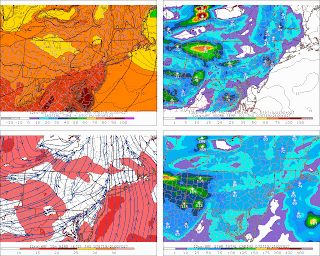
We may start of with sunshine tomorrow, but clouds should gradually increase as a strong upper level impulse approaches the region from the west. Mid afternoon temperatures will likely rocket into the lower 90s before showers and thunderstorms begin breaking out across the region. The Storm Prediction Center currently has the Mid Atlantic outlined under a slight risk of severe thunderstorms for tomorrow afternoon and evening. I think a few strong to intense thunderstorms will develop around the metropolitan region, but most should remain under severe limits (hail greater than 3/4" and/or wind gusts 58 mph).

Image at right: Showers and thunderstorms developing throughout the Mid Atlantic and Northeast as temperatures soar into the upper 80s and lower 90s.

Image courtesy of the PSU Meteorology Website

Extended:
Showers and scattered thunderstorms will likely persist into the nighttime hours Thursday before clearing out of the region by Friday morning. Temperatures during the afternoon will return to near-normal levels (in the mid to upper 80s), and fall into the lower 80s for the weekend.

The British Open:
The 136th British Open Championship starts tomorrow, Thursday, at famed Carnoustie golf links in Carnoustie, Scotland. Showers are in the forecast for first round play, before clearing up for the second round on Friday.
By Lee Carlaw On Wednesday, July 18, 2007 At 8:17 PM
|

Severe storms likely this afternoon...

2:00 UPDATE: It doesn't look like there was enough destablization in the atmosphere this morning-early afternoon to allow a major severe weather outbreak. A couple of strong storms may emerge from the Mason-Dixon line and push south and east, but as a whole, we will have to wait until Thursday for a major outbreak of severe weather...


Radar image at 2:15 showing a couple of isolated storms around the area, but nothing severe. The best chance for seeing an isolated strong storm tonight will be east of the city.

---------------------------------------------------------------

The National Weather Service has put the immediate metro ara under the slight risk area for severe storms for today and tomorrow.

This afternoon--- a weak shortwave associated with the residue from yesterday's storms over the upper Plains states (Iowa in particular) with pass through the area later this afternoon and kick off some thunderstorms in the process.

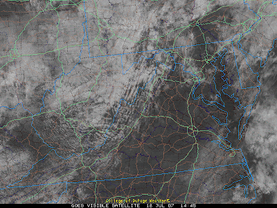
The one feature that the NWS indicated might reduce the risk of severe storms over the area is the lack of daytime heating. However, a look at the morning satelite (below) indicates that most of the area, with the exception I-495 remain cloudless at the current time.

Expect a number of storng storms capable of damaging winds or even an isolated tornado (EHI values and sheer are both respectable for the chance of a weak tornado). I would expect the NWS to issue a Severe Thunderstorm watch at around 2-3pm...


A look at the Satellite image at 10:45 AM today reveals that most of the area is undergoing modest daytime heating--- an important ingrediant for severe storms.
By John Y. On At 9:49 AM
|

A break in the action today, more to come Wednesday-Friday...

After a crazy afternoon yesterday, one in which nickel size hail and strong winds damaged a number of areas in northern Maryland and south-central Virginia, Tuesday will feature much calmer and more stable weather.

Wednesday-Friday, on the other hand will feature a return to the thunderstorms. Some of these storms particulary Thursday (it is still unclear whether or not the front will be able to clear the area by Friday afternoon) will have to be watched.

More to come tomorrow.


Can you see the front? Whenever you can go from 90% to 20% humidity in about 30 miles, you are going to see strong storms. (This is a map for 8pm Thursday).

By John Y. On Tuesday, July 17, 2007 At 10:28 AM
|

SEVERE THUNDERSTORM WATCH IN EFFECT UNTIL 9:00 EST

The National Weather Service has issued a severe thunderstorm watch for the entire DC metropolitan area until 9pm this evening.
Thunderstorms are increasing in coverage across the eastern slopes of the Appalachians, and
will move slowly into increasingly unstable air this afternoon.

What is most impressive however, is that the noon air sounding from the area recorded a lifted index at 500mb of around -4 degrees, which means that if a parcel of air is risen to 500mb (the middle layers of the atmosphere), it will be 4 degrees warmer than its environment and thus, continue to rise. As a result, cloud tops of over 55,000 feet will be possible in stronger storms.

It is likely that stronger complexes of storms will form bow echos this afternoon, so damaging winds appears to be the biggest risk with any storm that does form.

I think that the storms will be able to move into the immediate DC area from west to east between 5-7pm, although storms will be possible before then particularly south and west.


Radar image at 2:15 showing storms beginning to develop across the eastern slopes of the Appalachians, particularly south and west of DC.

By John Y. On Monday, July 16, 2007 At 1:10 PM
|

Storms NW for Sunday, everywhere for workweek...

Storms will be likely in the northern and western suburbs of DC Sunday evening, but it won't really be until Monday when most of the area sees widespread thunderstorms (some of which may be strong).

The OOZ NAM model (below) shows the linear nature of the storms Sunday evening over PA and WV drifting southeast, however, it doesn't look like these storms will have enough steam to reach the immediate metro area.


Areas north and west of line from Frederick to Winchester run the best risk for damaging winds with this line of storms, and it not impossible that the line sticks together long enough give even the immediate metro area some rain/thunder. If anything were to happen, it would not be until after 6pm.

Some thunderstorms may be strong to severe from Monday to Thursday as a stationary front keeps up humid and unstable, so additional updates will be provided.
By John Y. On Sunday, July 15, 2007 At 12:58 AM
|

Storms, but Nothing Out of the Ordinary...

Those of you hoping for a major severe weather outbreak this afternoon are going to be dissapointed to hear that I don't believe there will be one in the immediate metro area.
A look at the satellite image tells the story (below).


Notice the cloud cover in advance of the cold front? This overcast will weaken our chances to get sufficent instability in the afternoon and evening.
The best chances for anything severe today in north and east of DC, although I do believe that most of the region will see something in the way of rain/thunder--- just nothing severe.
If any watches or warnings are issued, updates will be posted....
By John Y. On Wednesday, July 11, 2007 At 11:55 AM
|

A Few Strong Storms Today, More Tomorrow...

With air temperatures are in the upper 90s, and dew points are in the upper 60s, its easy to see why a number of storms have popped up over the region this afternoon. I doubt any of these storms will become severe, due to a lack of sheer in the atmosphere, but heavy rain and dangerous lightning are possible in some of the storms (I saw about 20 cloud-to-ground strokes of lightning with a storm that moved just east of my Silver Spring office at about 12:30pm today...). The best chance of for storms will be south and west of DC.

The National Weather Service has extended the slight risk area for severe weather to include the entire metropolitan DC area for tomorrow... damaging winds area the greatest risk.


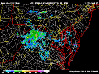
Radar image at 12:50pm showing a number of pop-up storms across the area. Severe storms are not likely this afternoon, but tomorrow may be a different story.
By John Y. On Tuesday, July 10, 2007 At 11:40 AM
|

An old-fashioned D.C. Heat Wave...

A strong Bermuda high will keep us dry and warm through the rest of this week, and at least the first part of next week. Temperatures the next several days will climb well into the 90s, and may even approach 100 degrees by Monday-Tuesday.

The only bit of good news is that the humidity will not accompany the heat until Tuesday or Wednesday at the earliest.


NAM Temperature forecast for Monday, predicting a 1pm temperatur of over
36 degrees Celsius or 97+ degrees Fahrenheit


At least the humidity won't be around until Tuesday-Wednesday: the NAM
model predicts us to be at about 30% humidity at 1pm Monday.

By John Y. On Friday, July 06, 2007 At 2:38 PM
|

Showers, Storms on Tap for Thursday...

After a crazy 4th of July, things will settle down a bit today. While the northern D.C. area is still under a slight risk for severe weather, given the lack of instability from all of the cloud cover, I do not think the area will see much in the way of strong storms today.

With that said, I am confident that almost everyone around the area will see some rain this afternoon and evening. There may even be some thunder or wind in some of the stronger thundershowers, but fortunatly, not much in the way of severe weather.

If any severe weather does arise, we will have updates...


Radar image at 12:30 showing a wide expanse of showers over

the Apalachians... most of the area should see these pockets of

showers/thundershowers this afternoon/evening

By John Y. On Thursday, July 05, 2007 At 11:13 AM
|

TORNADO WATCH IN EFFECT UNTIL 10:00PM....

7:10 UPDATE: SEVERE THUNDERSTORM WARNINGS CONTINUE FOR MONTGOMERY COUNTY AND PRINCE GEORGES COUNTY IN MARYLAND...

Discussion: Most of the severe weather, particularly the tornado risk has diminished... EHI values have droped below 2 across the area after peaking at about 3.5 around the 4pm time. This means that most of tornadic activity (3 separate reports of funnel clouds, 1 reported touchdown) has ended.

However, as radar continues to indicate, there are stil a number of thunderstorms that have to cross the immediate metro area in the next several hours. With that said, I do expect the fireworks on the mall to go on as planned, but earlier shows across the area may be in difficulty.


If you are south of the city, I think you are completely done with the thunderstorm risk, but north of the city, periodic thunderstorms will continue for the next several hours.


5:00 UPDATE: TORNADO WARNING FOR SOUTHERN LOUDOUN, NORTHERN FAQUIER, AND NORTHERN PRINCE WILLIAM COUNTY.

A number of spoters reported a funnel cloud with the storm moving through northern Montgomery County. Also, one spotter recorded 1.5 inch size hail! So yes, take these warnings serously!

For those of you planning of going down to the Mall tonight, please stay put until at least 7pm when this line hopefully has moved through the district.

4:30 UPDATE: TORNADO WARNING FOR NORTHERN MONTGOMERY COUNTY... People planning on attending firework displays in the evening (7-10pm) should really think twice before going. Hopefully, we can get these dangerous storms out of the area before 9pm.


4:00 UPDATE: SEVERE THUNDERSTORM WARNINGS REMAIN IN EFFECT FOR NORTHERN MONTGOMERY, SOUTHERN FREDERICK, NORTHERN FAQUIER, AND CLARK COUNTIES. People in the immediate DC metro area should expect in increase in thunderstorm coverage by 6 PM.


As I had anticipated yesterday, the NWS has issued a tornado watch for the entire DC area until 10:00 tonight.

People should be very careful before planning to go to any 4th of July celebrations around the area, and should listen to any additional warnings as they are issued...
By John Y. On Wednesday, July 04, 2007 At 1:05 PM
|

July 4th Bombers...

This morning, I am getting increasingly concerned about the chances for strong storms that may interfere with 4th of July evening celebrations across the D.C. area. My concerns are in line with the NWS, which went ahead and extended the slight risk area for severe storms tomorrow to include the immediate western subburbs of the District.

The flow aloft tomorrow will be from the Northwest while at the low levels, the flow will be from the southwest. That will lead to increasing shear and the potential for supercells to develop that can support tornadoes and large hail.

Why do we always show the lifted indexes? Because Storms needs enough lift
to rise to 45,000 feet + for them to be of concern. Tomorrow evening, lifted indexes at 7pm (shown) will be at about -4, meaning that at 500 mb, a parcel of air will be 4 degrees warmer than its environment (meaning that it will keep rising).


The dangers Wednesday are not associated with the cold front (we will have to worry about that Thursday) but the warm front. Warm fronts are less likely to spark squal lines, but carry a greater risk for tornadic activity. We can show this on a Energy Helicity Index (EHI) Plot (below). These plots measure the risk a given supercell has at becoming tornadic--- and tomorrow the risks are relatively high. While this does not mean we are going to have a tornadic outbreak tomorrow evening, people should check local radars, watches, and warnings before heading out (or just check out the blog!).


EHI values at 7pm tomorrow are expected to be at about 2 in the
city, and 3+ in the western subburbs--- meaning that any supercells
that develop run the risk of spawning a tornado

By John Y. On Tuesday, July 03, 2007 At 10:26 AM
Contact Us
wxdude1990 (at) yahoo.com jyarsh381 (at) hotmail.com

Donations


Useful NOAA Weather Links
Local Weather Service Office
Hydrometeorological Prediction Center
Storm Prediction Center (Severe Weather)
National Hurricane Center

Watches, Warnings, Advisories
Warnings

Numerical Weather Models
NCEP Models (good selection)
PSU E-Wall
25 km WRF model (Hi-Res)
Earl Barker's Model Page
Ensemble MOS data (Washington, DC)

Radar and Satellite
Local Radar

PSU E-Wall Satellite
Local NWS radar
ABC Radar
FOX Radar
NBC Radar

Other Weather Blogs
Capitalweather.com
USA Today's The Weather Guys
The Weather Underground blog
Foot's Forecast
Weather Talk Radio
Eastern US Weather Forum
Phillyweather.net

Other Blogs
BayArea Kicks

Enter your e-mail to subscribe:


Personal Blogs - Blog Top Sites

Subscribe

Personal blogs
Top Blogs

Creative Commons License
This work is licensed under a Creative Commons Attribution 3.0 License.

Archives