Local Forecast
Weather Wars: 7 Day Forecast Battle
Days Mon Tue Wed Thu Fri Sat Sun
Lee C. -- -- -- -- -- -- --
John Y. -- -- -- -- -- -- --
Temperature Verification
Days Mon Tue Wed Thu Fri Sat Sun
Temps -- -- -- -- -- -- --
|

DCweather's Winter Outlook

Precipitation Forecast:
Over the years, the ENSO (El Niño-Southern Oscillation) Index has been used, to great effect, to predict long term inter-seasonal variability in temperature anomalies across the United States. Generally, La Niña occurs when Sea Surface Temperature Anomalies from an area bounded from 5°N-5°S 120°W-170°W (also known as Niño 3.4) drop to less than 0.5 degrees Celsius.

Boxed areas represent the so-called Niño regions. Niño 3.4 is generally used in most long-term forecasts. Image courtesy of the Climate Prediction Center

At the end of the August-September-October time period, Niño 3.4 was at -0.8 and falling, meaning average SST anomalies for that region were 0.8 degrees Celsius below normal. Model forecast for the ENSO index indicate that SSTs should continue to fall through the remainder of the year and into next January. The NCEP CFS model, in particular, drops the ENSO index down below -2, which would approach some of the lowest monthly values every recorded.


More likely, however, is the threat of a moderate to strong La Niña through next January which would indicate drier than normal conditions across the Southeast and Mid Atlantic States, and generally warmer than average temperatures.

La Niña generally predicts precipitation anomalies a little better than temperature anomalies, at least in this part of the United States, so I am using the ENSO index more for this aspect of the winter forecast.

In short, I anticipate a drier-than-normal period from December through next January for the entire Southeast and Mid Atlantic. (This could be a bad thing for you snow-lovers, but keep reading).

Temperature Forecast:
Temperatures are normally a little harder to predict this far in advance. Unlike the teleconnections for precipitation, the comparisons aren't as black and white. Temperatures can be affected by the position of the jet stream, North Atlantic Oscillation, Pacific/North American Pattern, the Arctic Oscillation, Southern Oscillation Index, and a list that goes on too long to complete.

As a rule, though, the North Atlantic Oscillation (NAO) and Pacific/North American Pattern (PNA) are the most reliable predictors of temperature anomalies.

The NAO index, which measures pressure differentials between areas around Greenland, is currently at 0.45 and falling slowly. Likewise the PNA was 0.55 and falling rapidly. The years that best represented our current set-up are: 1963, 1969, 1995, and 2005. These years produced below-normal temperature anomalies across the Eastern third of the country, as seen at right.

Based on this information, and combining it with the fact that the ENSO should be negative for much of the winter, I think temperatures will be average to slightly below average through January.

Snowfall:
With La Niña in place, we will likely not be seeing an above average year for snowfall. However, I think we may be able to squeeze out a slightly below average year for most of the area (that works out to be around 10-14 inches at Reagan National, and 13-16 inches up north towards Baltimore. There will likely be more storms that drop a mixture of snow, rain, and freezing rain over the Mid Atlantic due to the milder air.
By Lee Carlaw On Wednesday, November 28, 2007 At 6:23 PM
|

Running Clipper Happy

If there is one thing I have learned over the years, it is that computer models do not ever do a good job with clipper systems. In fact, you'll see in my previous entry which came last weekend I talked about how a clipper could give us some snowflakes Friday night- Saturday if everything went as the GFS was showing on that day. But between Sunday and Wednesday, the clipper all but disappeared from the computer models.... until today.

It now looks likely that a clipper will pass through the area just to our south and west. As it does so, it will spread precip into the entire area. The question is, what form will it come in? Unfortunatly, I don't really have an answer. Looking at the conditional probabilities on the NAM and GFS, it could go either way. If I were to had to put something on it, I don't think anyone south and east of DC will see anything in the way of snow, and snow in the district may be a stretch. I do think it is fairly possible that the immediate suburbs of Montgomery, Fairfax, Frederick (etc) could see snow.

It will all come down to a couple of degrees Friday night, so if you are rooting for the first flakes of the year, stay close to a thermometer!

(I'd show you a picture here but there have been some technical difficulties...)
By John Y. On Thursday, November 08, 2007 At 4:48 PM
|

Welcome to winter next week!

A strong cold front will cross the area Monday night and send us into a very winter-like pattern for the remainder of next week. Temps will fall during the day Tuesday, with highs in the low 50s and gusty winds. On Wednesday and Thursday, highs will struggle to get out of the 40s, with nighttime lows in the 20s to around 30 in the city. Things will get interesting on Friday:

The GFS and EURO models have been hinting that two clippers, particularly the latter, may give us our first snow of the year. The first clipper is the weaker of the two, and and would perhaps give us a few flurries/drizzle on Wednesday night-Thursday. The bigger storm would be Friday night-Saturday.

If this were January, I would say that this storm would have the potential for several inches of snow.... but its November. As such, it is possible that if everything were to go right that we get some snowflakes or a very chilly rain during the period in question. Lots can change between now and then, but the underlying theme here is that a winter-like pattern will take shape next week.


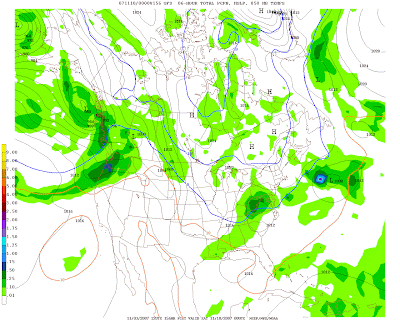
12z GFS showing moderate snow over the area on Friday.
By John Y. On Saturday, November 03, 2007 At 12:40 PM
Contact Us
wxdude1990 (at) yahoo.com jyarsh381 (at) hotmail.com

Donations


Useful NOAA Weather Links
Local Weather Service Office
Hydrometeorological Prediction Center
Storm Prediction Center (Severe Weather)
National Hurricane Center

Watches, Warnings, Advisories
Warnings

Numerical Weather Models
NCEP Models (good selection)
PSU E-Wall
25 km WRF model (Hi-Res)
Earl Barker's Model Page
Ensemble MOS data (Washington, DC)

Radar and Satellite
Local Radar

PSU E-Wall Satellite
Local NWS radar
ABC Radar
FOX Radar
NBC Radar

Other Weather Blogs
Capitalweather.com
USA Today's The Weather Guys
The Weather Underground blog
Foot's Forecast
Weather Talk Radio
Eastern US Weather Forum
Phillyweather.net

Other Blogs
BayArea Kicks

Enter your e-mail to subscribe:


Personal Blogs - Blog Top Sites

Subscribe

Personal blogs
Top Blogs

Creative Commons License
This work is licensed under a Creative Commons Attribution 3.0 License.

Archives