Local Forecast
Weather Wars: 7 Day Forecast Battle
Days Mon Tue Wed Thu Fri Sat Sun
Lee C. -- -- -- -- -- -- --
John Y. -- -- -- -- -- -- --
Temperature Verification
Days Mon Tue Wed Thu Fri Sat Sun
Temps -- -- -- -- -- -- --
|

Storms lining up for Evening...

A SEVERE THUNDERSTORM WATCH IS IN EFFECT UNTIL 10:00 PM EST FOR THE 1-81 CORRIDOR WESTWARD.

Discussion: A slow moving front will put an end to our unseasonable heat tonight, and as it does so, severe thunderstorms will be possible across the northern and western suburbs. The biggest risk for these storms is the heavy rainfall, which could exceed 1-3 inches/hour in heavier cells.

We need all the rain we can get, and its quite possible that the immediate metro area sees a solid half inch of rainfall tonight as the storms move weaken as they push into the area. I am confident that most locales will see some rain with this system, although the true soaking rain will stay north and west of the immediate DC area.

Projected times of the first drops:
Winchester: 5:30
Hagerstown: 6:00
Frederick: 6:30 (although a pop-up storm did drop some rain earlier today...)
Werenton: 7:30
Fairfax: 9:00
Rockville: 9:30
Washington D.C.: 10:00
Baltimore: 10:30
Anapolis: 11:00
Fredericksburg south: rain not likely.


A line of strong storms has the potential of dropping some significant rain over the area tonight.

By John Y. On Thursday, September 27, 2007 At 3:56 PM
|

Nice weather for Weekend...Watching Gulf of Mexico closely

Nice weather is on tap for the weekend as a weak cold front approaches the area from the northwest. Winds wil shift to the southwest on Friday bringing in almost August-type heat and humidity. While we can't rule out a shower or thunderstorm on Saturday, skies will remain more or less clear for the weekend.

A weak cold front will fizzle out on Saturday as it approaches the area. Expect a Summer-like weekend with temps in the mid 80s both days.

----------------

Watching Invest 93L:

The National Hurricane Center investigated invest 93L in the Gulf of Mexico near Florida and found a well-defined low-level center and a pressure of 1006mb (what you would expect in a tropical depression). The only issue is that the system doesn't have very many tropical features at the moment, with little convection near the low-level center. None the less, conditions are becoming favorable for 93L to become a sub-tropical or tropical storm in the next day or two as it drifts westward. People in the southern Gulf should pay attention to this system--- computer models seem to agree that the most likely place for the system to make landfall would be western Louisiana. From there, it is possible that we get some rain just as we did when Gabby came ashore in Texas last week.


By John Y. On Thursday, September 20, 2007 At 8:11 PM
|

Storms lining up for this evening....

Heavy rainfall associated with slow moving thunderstorms will be possible over the next several hours as a wave of low pressure moves up a nearly stationary front and spreads moisture over the extremely humid air mass in place (Gabriel left behind very high dew points when it departed).

Although a widespread severe weather event is not anticipated, a couple of damaging wind reports are possible. The heavy rainfall, in some of the heavier cells though will be the main threat. Hopefully we can get some rain from this system...


Radar does not look too impressive right now, but by this evening, heavy thunderstorms will blanket the area...
By John Y. On Monday, September 10, 2007 At 2:58 PM
|

Gabriel a close call...

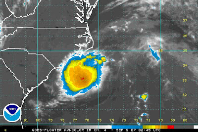
It took a little longer than expected, but the area of disturbed weather off the North Carolina Coast finally became tropical in nature this afternoon (at first, the NHS listed it as a subtropical storm....don't ask me what made it "tropical" by 5pm but "sub-tropical" at 2pm).

At this point, Gabriel is a weak tropical storm with winds sustained at 40mph (although I do think that may be underdone a bit). While the track of Gabby (below) indicates that nobody west of the Eastern Shore will be impacted by the storm, in recent hours, the tropical storm has wobbled a bit west which may in turn take the track a bit further west.


This westward trend must be monitored, and I do still think that there is an outside chance that Gabby reached hurricane status before making landfall in Eastern Carolina. Unless something drastic happens however, it doesn't look like Gabby will be one for the memories.


Gabriel looking better tonight...

-------------------

In other weather news, a slowly dropping front (the same front that is going to keep Gabriel away) will give us a chance for some storms Monday. Some of these storms on Monday may reach severe limits. After there, it looks like a clear and calm weather pattern will settle in, giving us seasonable weather for the remainder of the workweek.
By John Y. On Saturday, September 08, 2007 At 10:30 PM
|

Soon-to-be Gabriel is something to watch...

At 3:30pm Wednesday, new recon reports showed that the area of circulation southwest of Bermuda is very close to tropical depression status. Chances are high that by Thursday we will have tropical storm Gabriel, and computer models are indicating that there is a chance that Gabriel will strenghten and move west towards the North Carolina Coast, potentially impacting the DC area by the end of this weekend with heavy rain and strong winds.


Stay tuned...
By John Y. On Wednesday, September 05, 2007 At 4:36 PM
|

Perfect stretch of weather to continue... Felix, 98L developing...

Sunday Night Update: Hurricane Felix strengthened rapidly today, reaching category 5 status this evening. Just to get a sense of the strength of this storm, when NOAA recon planes flew into the storm earlier today, they found lightning in all quadrents (usually something we only see in hurricanes that are truly exploding in intensity) and graupel (small frozen water droplets/hail that can were obviously large enough to damage the plane), and ultimately had to abort the mission. The plane also recorded a 1mb drop in pressure per mile when flying into the storm. That will make your ears pop like CRAZY!!! Felix should level out in terms of winds Monday, and continue fluxuating in intensity between strong CAT 4 or CAT 5 until its landfall.

There is little change in the forcasted path--- Felix should continue west-northwestward towards Northern Honduras and Belize. There is still a slight chance that Felix will move far enough north to make a US landfall in Texas after its initial landfall somewhere in Belize or the
Yucatan.
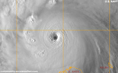

CAT 5 Felix Sunday night


---------------------------------------

On the home front, a strong ridge of high pressure has moved into the area, and there is no indication that anything other than sunny skies and warm temperatures will persist well into the future. Temperatures will start to get up there to around 90 by Labor Day, and stay in the upper 80s through the week with no rain in the forecast.
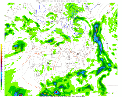


A perfect weekend followed by a perfect week of weather

On to the tropics, where things are starting to heat up again:

Felix: Hurricane Felix (winds sustained at 70mph on Saturday) will continue to move west-northwestward towards the southern Carribean. Most of the models keep the storm well south of the Gulf Coast and take the storm into the Yucatan Penninsula, however some models have begun to shift northward. Trends will need to monitored.

98L: This system has strengthened significantly today, and should reach tropical depression status by tonight or tomorrow. It is far to early to tell, but 98L has a chance to be threat to the east coast by next week.

By John Y. On Saturday, September 01, 2007 At 2:41 PM
Contact Us
wxdude1990 (at) yahoo.com jyarsh381 (at) hotmail.com

Donations


Useful NOAA Weather Links
Local Weather Service Office
Hydrometeorological Prediction Center
Storm Prediction Center (Severe Weather)
National Hurricane Center

Watches, Warnings, Advisories
Warnings

Numerical Weather Models
NCEP Models (good selection)
PSU E-Wall
25 km WRF model (Hi-Res)
Earl Barker's Model Page
Ensemble MOS data (Washington, DC)

Radar and Satellite
Local Radar

PSU E-Wall Satellite
Local NWS radar
ABC Radar
FOX Radar
NBC Radar

Other Weather Blogs
Capitalweather.com
USA Today's The Weather Guys
The Weather Underground blog
Foot's Forecast
Weather Talk Radio
Eastern US Weather Forum
Phillyweather.net

Other Blogs
BayArea Kicks

Enter your e-mail to subscribe:


Personal Blogs - Blog Top Sites

Subscribe

Personal blogs
Top Blogs

Creative Commons License
This work is licensed under a Creative Commons Attribution 3.0 License.

Archives