Local Forecast
Weather Wars: 7 Day Forecast Battle
Days Mon Tue Wed Thu Fri Sat Sun
Lee C. -- -- -- -- -- -- --
John Y. -- -- -- -- -- -- --
Temperature Verification
Days Mon Tue Wed Thu Fri Sat Sun
Temps -- -- -- -- -- -- --

Perfect stretch of weather to continue... Felix, 98L developing...

By John Y. On Saturday, September 01, 2007 At 2:41 PM
Sunday Night Update: Hurricane Felix strengthened rapidly today, reaching category 5 status this evening. Just to get a sense of the strength of this storm, when NOAA recon planes flew into the storm earlier today, they found lightning in all quadrents (usually something we only see in hurricanes that are truly exploding in intensity) and graupel (small frozen water droplets/hail that can were obviously large enough to damage the plane), and ultimately had to abort the mission. The plane also recorded a 1mb drop in pressure per mile when flying into the storm. That will make your ears pop like CRAZY!!! Felix should level out in terms of winds Monday, and continue fluxuating in intensity between strong CAT 4 or CAT 5 until its landfall.

There is little change in the forcasted path--- Felix should continue west-northwestward towards Northern Honduras and Belize. There is still a slight chance that Felix will move far enough north to make a US landfall in Texas after its initial landfall somewhere in Belize or the
Yucatan.
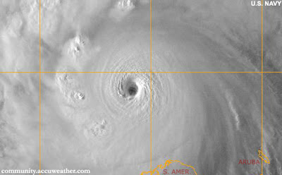

CAT 5 Felix Sunday night


---------------------------------------

On the home front, a strong ridge of high pressure has moved into the area, and there is no indication that anything other than sunny skies and warm temperatures will persist well into the future. Temperatures will start to get up there to around 90 by Labor Day, and stay in the upper 80s through the week with no rain in the forecast.
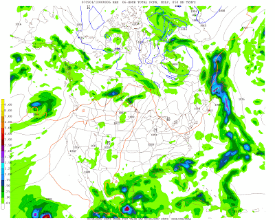


A perfect weekend followed by a perfect week of weather

On to the tropics, where things are starting to heat up again:

Felix: Hurricane Felix (winds sustained at 70mph on Saturday) will continue to move west-northwestward towards the southern Carribean. Most of the models keep the storm well south of the Gulf Coast and take the storm into the Yucatan Penninsula, however some models have begun to shift northward. Trends will need to monitored.

98L: This system has strengthened significantly today, and should reach tropical depression status by tonight or tomorrow. It is far to early to tell, but 98L has a chance to be threat to the east coast by next week.

for this post

Leave a Reply

Contact Us
wxdude1990 (at) yahoo.com jyarsh381 (at) hotmail.com

Donations


Useful NOAA Weather Links
Local Weather Service Office
Hydrometeorological Prediction Center
Storm Prediction Center (Severe Weather)
National Hurricane Center

Watches, Warnings, Advisories
Warnings

Numerical Weather Models
NCEP Models (good selection)
PSU E-Wall
25 km WRF model (Hi-Res)
Earl Barker's Model Page
Ensemble MOS data (Washington, DC)

Radar and Satellite
Local Radar

PSU E-Wall Satellite
Local NWS radar
ABC Radar
FOX Radar
NBC Radar

Other Weather Blogs
Capitalweather.com
USA Today's The Weather Guys
The Weather Underground blog
Foot's Forecast
Weather Talk Radio
Eastern US Weather Forum
Phillyweather.net

Other Blogs
BayArea Kicks

Enter your e-mail to subscribe:


Personal Blogs - Blog Top Sites

Subscribe

Personal blogs
Top Blogs

Creative Commons License
This work is licensed under a Creative Commons Attribution 3.0 License.