**FLOOD POTENTIAL**
Isolated thunderstorms and heavy showers across the region have started flooding in several areas. Thunderstorms are moving very slowly, and are dropping copious amounts of rainfall in the isolated places they are ocurring. Through the night, be prepared for flooded roads, especially in low-lying or hilly terrain. On this first full day of summer, temperatures have soared into the low 90s under partly sunny skies and a breezy northwesterly wind. The good news is that dewpoints are relatively low--hovering around 60 degrees--which isn't adding too much of that sticky feeling outside.
 Severe Weather
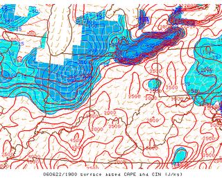
While widespread severe thunderstorms are not anticipated, the Storms Prediction Center has placed parts of the region under a slight risk for severe thunderstorms. Surface Based CAPE-- which is a measure of how unstable the atmosphere is, and, hence reveals how likely thunderstorms are to become severe--is very high, ranging anywhere from 2000 to 3000 Joules/Kg. Thunderstorms thrive in this kind of setup, so any storms that manage to fire later today have the potential to produce damaging winds and small hail.
Washington D.C.'s PGA Tour Stop:
 The Washington areas only PGA tour event settles in at the TPC at Avenel. The Booz Allen Classic (Once called the Kemper Open) is being played today just down the road from Congressional Country Club.
Conditions will remain warm through the tournament, with a 20-40 percent chance of a shower or thunderstorms in the afternoon. Spectators might want to bring a small umbrella just in case.
The HEAT INDEX measures the combination of humidity and temperature at a given location. The index reveals what it feels like to the skin outside, and any values over 95 can be dangerous. Heat Indicies may briefly reach 95 or so at the tournament today, but expect slightly cooler conditions tomorrow.


for this post
Leave a Reply