Weather Record
Did you think it was warm yesterday? Well, a record high of 78 degrees was set today at Reagan National Airport, breaking the previous record of 77 set back in 1964.
Tonight and Tomorrow:
Clouds will continue to stream in from the north and west as the sun sets, associated with a diving Canadian trough. Low temperatures should remain in the lower 50s for the most part as daytime radiation gets trapped under the cloud cover. A small, 20 or 30 percent chance of an isolated shower will persist through the night.
Tomorrow, a warm front will lift north of the region, allowing the temperatures to once again soar past 70. Any showers (or thunderstorms) that develop tomorrow should be few and far between, but be aware there will be a small chance of showers tomorrow afternoon.
 Is Winter really over?
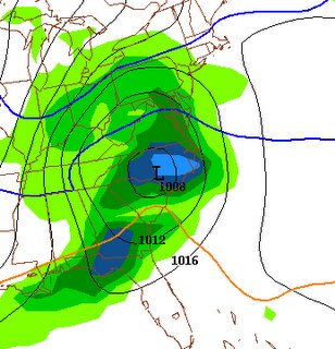
I have been cautious to post the "winter cancel" messages even with the prospect of 70+ degree weather for an extended period of time. Lo and behold, the GFS, NOGAPS and Canadian models all show some signs that would point towards another cold and snowy period developing late next week. Granted, the synoptics and upper-air pattern are not ideal for a major snowstorm, but GFS precip progs are impressive to say the least.
Surface temperatures would most likely inhibit snowfall accumulations (but it would be nice to see some snow before winter shuts its doors).


for this post
Leave a Reply