
Models have trended southward with the system for Monday/Tuesday. There is still a small chance for flurries around the region Monday afternoon, but that's about it.
If you thought the weather today was sweet, just look ahead to tomorrow. Temperatures should soar into the upper 50s/lower 60s under partly cloudy conditions as a midlevel ridge sets up shop along the Eastern Seaboard.
Clouds will increase out ahead of a strong cold front during the morning hours on Friday, which will aid in keeping temperatures down somewhat, although, strong southwesterly winds will effectively neutralize this increase in cloud cover by advecting warmer air from the southern states. Expect highs to average out in the upper 50s.
 Temperatures over this President's Day weekend will drop of significantly, from the upper 50s into the lower and mid 30s. After Saturday, things get a bit interesting. A frontal boundary will likely stall out south of the District, setting up a strong "cold dome" over the Capital region. A slug of deep moisture is forecast to oscillate northward Sunday afternoon as weak waves of low pressure develop and move along this stalled cold front.
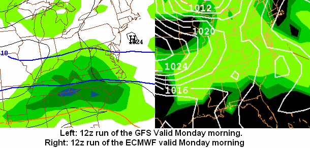
By Monday, there seems to be fairly good model support (at least for this time range) that would suggest an "overrunning" type event occurs, that is, warmer mid and upper level air rides over the "cold bubble" at the surface, squeezing out any moisture in the atmosphere. Depending on where the cold front stalls, how strong the wavlets become, and the position of the high pressure system off the coast, we could be looking at a pure snow event, or an icing event for President's Day.
Snowfall Photos:
Below are a few photos I was able to capture during and after last weekends snowstorm.


for this post
Leave a Reply