
By the time you wake up tomorrow morning, temperatures will have slipped into the mid 30s and skies will have begun clearing from west to east.
Massive Cool Down:
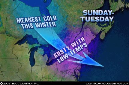 While the temperatures over the next two or three days will by and large be above average, a massive arctic intrusion (likely the most intense of the winter season) will make a move on the region Sunday and Monday, as a large dome of high pressure slides southeastward from the Canadian Provinces. I think GFS forecast high temperatures Monday through Wednesday are too low given the strength and position of this incoming polar vortex-which is basically a region of excessively below normal atmospheric heights, and below normal temperatures.
I can see highs on Tuesday struggling to break the freezing mark in most locations, especially north and west of the District as cold, -15 to -20C air around 1500 feet up slides overhead.


for this post
Leave a Reply