A Winter Weather Advisory is in effect for areas north and west of the District from 4AM to 9AM Tuesday morning. Icy road conditions are possible in the warned areas
 After the ridiculously windy conditions we experienced yesterday, things have calmed down a bit as we remain trapped between two weather systems--one departing around the Canadian Maritimes, and a developing low in the southeast. Over the next several hours, significant upper level divergence (winds spreading out along a set area, opposite of convergence, where winds converge on a set location) aids in strengthening the said low.
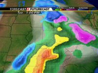
By mid-morning tomorrow, rain showers will have taken over the southeast portion of Maryland, and a potential wintry mix in the northwestern 'burbs as some shallow cold air remains trapped east of the mountains. With this said, there may be a few slick spots on the roadways north and west of the District tomorrow morning.
By Mid-afternoon, the bands of showers associated with a warm front punch north of the region, leaving us in a dryslot for a few hours before a strong cold front progresses over the Mountains. Hefty showers, and a few thunderstorms will break out once again overnight Tuesday and through the morning hours on Wednesday, before everything moves east of the region by 5 or 6PM.
Yet another chance for precip moves into the region next Saturday afternoon as another low develops in the Ohio River Valley.
As for temperatures, daytime readings will generally top out 10 degrees or so above average (in the lower 50s).
Image above right: Futurecast computer model showing the possibility of a little wintry-mix tomorrow morning
 Good News for the Snow-Lovers
Over the past few days, a massive Cold Vortex has moved off the Russian coast, and is currently situated a few hundred miles west of the Gulf of Alaska.
This will begin to set the stage for a "pattern reversal" by the end of January as the North Atlantic Oscillation switches over to negative (good for winter stuff in the District), and cold air spills southward in the Contiguous US sometime around the 25th to 27th of January.
The image to the right is the 12z run of the European Model showing a trough developing in the Midwest, cold air spilling southward into the United States, and, more importantly, a Negative NAO as a positive height anomaly sets up over Greenland. It's far too early to pinpoint the potential for winter storms, but the developing pattern would seem to favor a snowy end to the winter season. Cross your fingers...


Great Article