
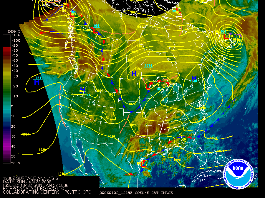
 For the first time in a long while, it actually feels like January. A strong cold front moved through the region last night, and is currently stalled across the Southeastern US. Moisture associated with a developing low off the Texas coast will slowly progress northeastward over the next 12-24 hours, and clouds will slowly begin to thicken as the day wears on.
Showers are set to invade the region overnight from southwest to northeast. By late Monday, most of the rain shower activity will have moved east of the Mid Atlantic, opening the door to a strong Canadian high pressure cell which will slide into the area during the middle of the week. Temperatures will fall back towards "normal" values, and even slightly below as northerly winds drag cooler Canadian air into the Eastern United States.
Will Winter hold on for February?
The average January temperature at Washington Reagan National Airport [43.5 degrees, 8.6 degrees above average] has moved into 6th place as the warmest January on record, behind 1890 (+8.9), 1913 (+8.7), 1932 (+11.9), 1933 (+7.7), 1950 (+13.1*), and 1990 (+8.7).
For the snow-lovers, most of us have already thrown in the towel and decided that winter cannot possibly make a come-back before March. So, how do February's following extremely warm January's stack up?
In January's where the mean temperature exceeded 6 degrees above normal [1880, 1890, 1913, 1932, 137, 1950, 1974, 1990, 1998, 2002] the February that followed generally featured above normal temperatures;
 in fact, the average February temperature was 3.4 degrees above the 130-odd year mean. The average snowfall following such January's was meager at best, with an average of 1.3 inches falling at Reagan National, however, there is a caveat:
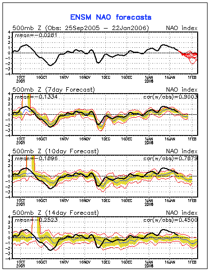
The North Atlantic Oscillation (NAO), which is the dominant mode of atmospheric behavior in the United States, remained within 1.5 standard deviations from 0 in the aformentioned years. Weakly positive, or weakly negative phases of the NAO generally have minimal impact on the weather in the Eastern US. Most numerical weather models, the GFS in particular, are adamant in developing a moderately negative NAO come February 1st, ranging anywhere from -1 to -4, which would favor colder conditions in the Eastern US.
In short, this is what I'm trying to get at: even though temperatures this month have been ridiculously high, things looks decent regarding a return to winter-like conditions come February, or at least for the first half of the month. There is some troubling data that would suggest the -NAO retreats after the 10th-15th of February, and force temperature back above normal. Still, the temperature forecast for February is on shaky ground. At this point my thinking is temperatures average anywhere from 0 to +1 above normal. Keep your fingers crossed...


Great Article