
 Old Man Winter has decided to take an extended vacation from the Capital region, and for the first time in a long while, I was able to walk around outside in shorts, DURING JANUARY! Even though a cold front associated with a clipper low to the north passed through the region last night, temperatures will still manage to crawl 5-10 degrees above normal this afternoon.
 Temperatures yesterday were able to top 60 degrees for the first time since November 29th of last year. While we won't be enjoying weather quite like yesterday's, temperatures today will still manage to crack 50 in most locations under partly sunny conditions.
Graphics courtesy of Accuweather, and PSU E-Wall
OUTLOOK:
On Wednesday, A developing area of low pressure in the Ohio River Valley should begin spreading low clouds and showers over the region by the early afternoon hours. I don't expect anything too severe tomorrow--mainly scattered, light rain showers. High temperatures should remain in the mid-upper 50s.
Thursday through Friday things clear out as we sit in between storm systems developing in the west, and departing lows over the Atlantic Ocean. Temperatures will take advantage of the increased solar radiation, and we will likely approach, if not top 60 degrees once again Thursday and Friday afternoon.
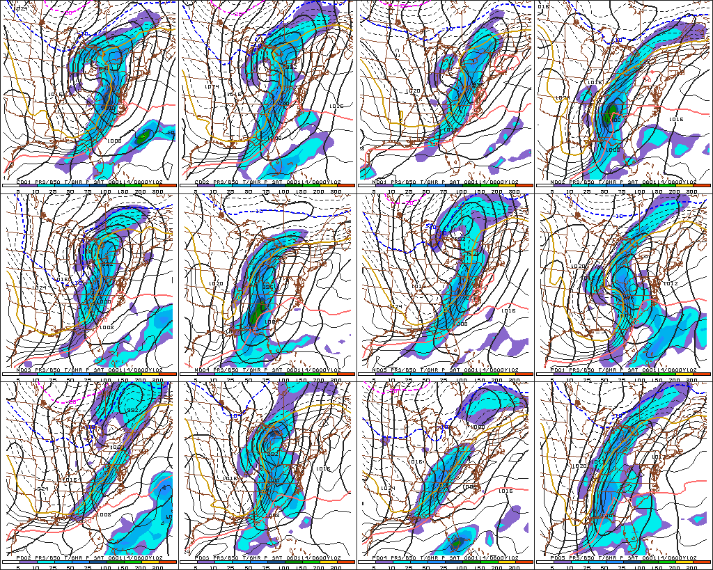 After this, things become quite interesting as many models develop an extremely intense cyclone in the Ohio River Valley once more over the weekend. Draw your attention to the image to the right. This graphic is what forecasters call ensemble model forecasting. Every numerical model has some sort of ensemble member forecast, and the images at right are those of the Global Forecast System (GFS) model.
This forecasting method was developed to improve medium and long-range numerical weather forecasting. Each run of the same model are started with slightly different initialization parameters (time, temperature, wind, etc.) to produce a forecast. If, at the observation time, all of the ensemble members are in reasonable agreement, the forecaster has better confidence in the forecast.
So, the graphic on your right is a host of negative, and positive perturbations (i.e. models where the physical properties of the atmosphere were changed slightly) of the GFS model at 102 hours valid early Saturday morning. As you can see, there is general model consensus of the placement and strength of an intense low pressure system affecting the region during this timeframe. But, as is normal at 100+ hours, there is some uncertainty regarding precipitation placement/onset times.
With this data, I can make a somewhat confident forecast for the weekend. Most of the ensemble members draw extremely warm/humid air from the Gulf Coast northward into the Mid Atlantic (notice that pink line jutting northward towards the Mid Atlantic, that's the 50 degree isotherm about 10,000 feet up in the atmosphere). Showers and thunderstorms will likely break out across the region late Friday night/Saturday morning, before exiting quickly during the evening hours.
Strong, northwesterly winds behind the system on Sunday will promote near normal, to slightly below normal temperatures in the upper 30s.


for this post
Leave a Reply