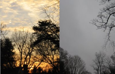
We went from gorgeous afternoon weather yesterday (left) to an abysmal day featuring low clouds like nimbostratus, which is a dark, moisture-laden cloud that is often associated rain or snow, depending on temperature. If you look closely out your window, you may occasionally see ragged-looking clouds beneath the thick nimbostratus known as stratus fractus (or scud cloud in laymans terms).
Showers are now congealing into a large stratiform mass. Rain should become heavier and steadier as we work our way into the nighttime hours, with some heft rainfall likely overnight. Showers will linger through much of the day tomorrow, but the heaviest activity will have departed the region before sunrise.
Wednesday/Thursday...A weak clipper-like low pressure system is expected to develop along the US/Canada border. As with most clipper lows, moisture inflow is minimal as they are, on all sides, more than 600 miles from any large body of water (which releases heat and induces clouds and precipitation). At this point, any precip that falls in association with this system should be rain, except in the far northern/western burbs of western MD and eastern WV. Temperatures may fall just enough to support some snowfall.
Saturday/Sunday...Recent runs of the global European Model (one of the best Mid-range numerical forecast models) reveal the potential for some type of wintry-like event in the Mid Atlantic over the weekend as a low slides up the East Coast. Moisture, and hence, precipitation looks a bit lacking, but temperatures would be cold enough to support snowfall. However, a major caveat in the forecast is the fact this model has very limited support from other numerical models. The GFS forecasts a dry weekend, along with the UKMET. One or two other models hint at this snowfall potential, but still keep precipitation well offshore.
As I like to say...Stay Tuned!


Great Article