
 It's hard to imaging that a day when temperatures soared into the upper 50s under crystal-clear skies, is also host to the deadliest snowstorm on record for the Washington, D.C. Metro region. On a particuarly gloomy day 84 years ago, nearly 30 inches of heavy, wet snow had accumulated over the region associated with a powerful Nor'easter, which expelled a pressure roughly around 20 pounds per square foot on the roof of Crandall's Knickerbocker Theater in downtown D.C. At 9PM, the tremendous weight of the snowfall split the theater's roof down the middle, killing 98 individuals and seriously injuring another 130.
Image courtesy of Weatherbook.com
Gloomy Weather tomorrow:
Needless to say, we won't be expecting a 30-inch snowstorm any time soon; in fact, we're expecting just the opposite--rain showers. A powerful jet stream racing through central Mexico and southeastern Texas is pumping tropical moisture northward into the Ohio River Valley. A surface low pressure system will gradually slide northeastward into the Great Lakes region by tomorrow morning. Showers will overspread the region during the early afternoon hours on Sunday, before racing out of the area around nightfall.
As for our *potential* wintry episode next week, things are still up in the air. It's basically a given that a secondary low develops along a stalled surface front Monday evening, but exactly when and where are still issues that have yet to be glossed over.
The National Center for Environmental Protection, the agency that developed the GFS, NAM (formerly the ETA), RUC, and WRF, recently dropped profilers in the North Pacific to give numerical model guidance a better edge in forecasting next week's storm system. (The basic principal behind this being the 'weather' moves in a predominantly west to east fashion following the jet stream, and the drops will allow the models to analyze upper weather features more accurately in tonight's runs). This added analysis data may end up throwing a monkey wrench into ongoing forecasts, but hopefully we can shed some more light on Tuesday's weather potential.
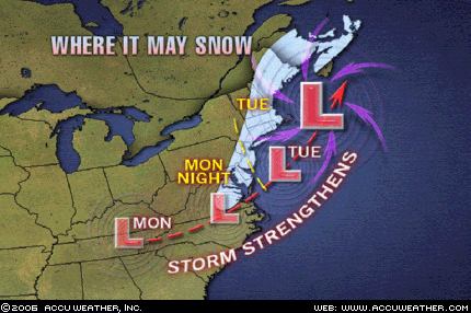
As with all the storms this season, there is no real source of cold air. We usually like to see a healthy high pressure dome in Upstate New York to funnel cold surface air into the Mid Atlantic (guess what, it's not there). So, any cold air will be completely low pressure induced, meaning as the low strengthens, it will have to do so quickly enough to pull colder mid-level air down to the surface before precip moves out of the region.
I'm not wowed by our chances for snow, but it's still there. I would say accumulating snow is out of the picture, but time will tell...


Great Article