 Temperatures today made it into the lower 50s under mainly sunny skies and calm winds. This is the first time in about 20 days that DC eclipsed the 50 degree mark.
I haven't been posting too much (not enough in my opinion), and part of the reason is this dull weather pattern we're in.
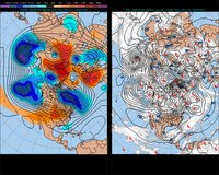
The upper level wind pattern (around 15-20,000 feet or so) has remained more or less zonal, or a west to east flow of the winds, which promotes a stagnant weather setup across the eastern half of the US, as very little energy is moved across the Continent.
The image at right is a depiction of the upper level wind pattern (left half) and reveals an almost purely west to east progression of the steering currents.
However, things are about to change as some energy ejects from southwestern Canada, and dives headlong into the Midwest tomorrow. This energy should begin to carve out a pretty significant trough in the mid levels of the atmosphere, and will send a low pressure system our way for Christmas. At this point, precipitation looks to remain all rain for the metro region, with some mixing possible farther north and west of the city early Monday morning.
Temperatures through next week will remain above average (44 degrees in Washington) as highs soar into the lower to mid 50s.
Something to Watch next week:
While significant timing differences exist between numerical weather models, it is becoming apparent that something has "got to give" in this weather pattern very soon. Long range guidance suggests that we are heading into a pattern change/re-load to start the 2006 season, and we can simply not make pattern reversals from 50-60 degree weather, to below normal temps without some atmospheric bombshell affecting the United States.
Models are hinting that this bombshell is developing along the eastern portion of Asia as we speak in the form of a monster trough (and associated below normal temperatures). Both the European Model (ECMWF) and Global Forecast System (GFS) move this developing trough eastward, and by the end of next week, show this dip in the jet stream inducing a large surface cyclone along the Eastern Seaboard (this should automatically send the fireworks off in any Washingtonian's head).
Forecast skill at this timeframe (around 144-200 hours out) is just not there, and confidence at this point remains extremely low. The aforementioned model solutions are a big change from last night's runs, which depicted near to above normal temperatures for the Mid Atlantic, with no hint of any surface low along the coast.
At this point, December 30-31st event is pure speculation, but definitely requires some careful monitoring.
There won't be any posts for the next week until I return from my "winter vacation." For those of you traveling this Christmas, stay safe and enjoy the Holidays.


Great Information.