The previously predicted 3-6 inches for the Greater DC area might have been a bit overdone, (figures) although we are approaching 1.5 inches in southern Montgomery County at this hour. Nearly 3 inches of the white stuff has accumulated in Fredericksburg, VA, and most locations around the region are reporting 2 inches of slushy snow at this time.
The radar presentation continues to improve, with distinct "banding" lines appearing throughout central MD. And as expected, the heaviest and steadiest snowfall is located southeast of the city, across St. Mary's county and the Fredericksburg areas.
A general T-2 inch swath is likely in northwestern MD, and eastern WV, while snow totals from 1-4 inches will be prominent closer to home. Be careful heading out on the roads tonight, as temperatures have fallen below the 32 degree mark.
WashingtonPost Article: "Snow Arrives in Washington"
School Closings: WUSA9 News
School Closings: WJLA 7 News
School Closings: NBC 4 News
 Winter Storm To Affect the Entire Mid Atlantic
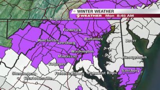
Winter storm warnings are in effect for south Central MD (St. Mary's County), and back southwest towards the southern Shenandoah Valley. The said regions should expect rather extensive snow accumulations of 6 to possibly 10 inches.
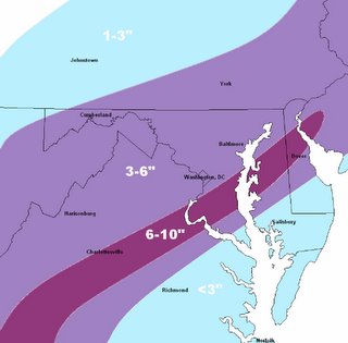
Closer to home in the District, my call for 3-6 inches still stands, so I'm basically re-iterating what I have stated in previous posts.
Snowfall Timeline:
10AM-Noon: Snow will continue movie northeastward as it saturates the atmosphere, although it is taking a little longer than anticipated for precipitation to saturate the lower levels. The first flakes should begin falling around the noon hour in the District (give or Take), but no accumulation is anticipated on the roadways. Grassy and sheltered surfaces may see some snow accumulations near 1-3 inches.
Noon-Midnight: Snow continues throughout the region, with some mixing of sleet/freezing rain in lower southern MD. Snow may become heavy at times, and I wouldn't be surprised to see some thundersnow around the area. (Basically a thunderstorm, but "raining" snow--this is really fun to watch).
Midnight-11AM Tuesday: Snow tapers to light snow showers after spurts of heavy snow as the low pressures "Comma Head" passes over the region. All precip is out of the region by the Noon hour on Tuesday.
Again, my forecast reasoning remains the same, and the forecast map below is a carbon copy of the map in the previous post.
Snowfall Accumulation map:

Storm Impact Potential: Medium, snow totals >5" prominent
School Closings: Good chances of delays, and fair chances of closings across the region.
Select Snowfall Predictions:
Washington, DC (KDCA): 3"
Baltimore, MD (BWI): 5"
St. Mary's: 7"
Cumberland: 2.5"
(We'll see how these hold up by Tuesday evening...)
Warning Map Courtesy of WUSA9


for this post
Leave a Reply