
DCweather.com Travel Cast:
 Today: The only impeding aspect to holiday travel this afternoon will be the winds. Gusts to 30 mph are occurring across the entire region at this time, and those of you traveling in high profile vehicles should use a little extra caution on the highways today.
 Tonight: For those of you hitting the roads later this evening, you could be in for a little taste of winter. Heading north in Pennsylvania along the I-95 corridor will be smooth sailing until about midnight. By that time, a developing Alberta Clipper should be located back in the upper peninsula of Michigan, and will likely be spreading **light** snow showers across central Maryland, and parts of PA. Please use caution on the roads tonight, as even light snow showers on warm ground can make travel hazardous.
If you're traveling southbound on the Interstate, still be on the lookout for some light snow showers/rain showers late tonight.
Thanksgiving Day: By sunrise, most of the flurries/snow showers will have exited the immediate metro region, but folks traveling in Pennsylvania, or into the Appalachian mountains should expect hefty snow showers, possibly accumulating to 2-4 inches.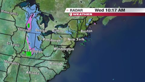 Metro region Outlook:
I'm sure the event on all of your minds is the impending clipper encroaching the region from the northwest. The image at right reveals snow showers already breaking out across portions of Michigan and the Ohio River Valley, all in association with the developing Clipper system.
Tonight, very weak forcing (known as UVV or OMEGA in weather-speak) moves into the region around 12AM-5AM tomorrow morning. The amount of OMEGA present at that time looks to be somewhere arond 5-10 microbars/sec, not a very large amount. However, there is a relatively good chance we see some light snow showers late tonight, but don't expect any accumulation on the road surfaces--maybe a little dusting on the grass.
And I think this is a good time for me to announce that I am snow-lover, and there might be some very small hints of "wishcasting" in this forecast. I have attempted to base this forecast solely on model trends, current analysis, etc., with as little outside thought intervention as possible.
Above Image courtesy of WUSA 9 Weather
Extended Outlook:
Not much to talk about at this point in the extended. High temperatures plummet into the 30s Friday and Saturday as the Alberta Clipper deals us another reinforcing shot of Arctic Air. By the end of November, some Numerical Models are pointing towards a short warm up, as an upper level ridge breaks down in the north central Atlantic (our -NAO).
It is too early to pinpoint details in this forecast, but I expect a general warming trend to commence after this weekend-and high temperatures should be able to poke their way into the mid 50s (maybe 60s?) by next week.
But snow-lovers don't fret. After November comes to a close, the potential for more Canadian Air invasions will once again come to life, along with the progression into a, dare I say, stormier pattern.


for this post
Leave a Reply