
Outlook the next few days:
The showers (occasionally moderate) around the Mid Atlantic are being spawned by some week vertical motion, coupled with Warm Air Advection from the south as a High pressure cell to the northeast lifts out towards the Canadian maritimes. I anticipate many of these showers will have progressed north and east of the region by tomorrow morning as a warm front attempts to break through areas downwind of the Appalachian Mountains.
 A forecast challenge develops tomorrow afternoon with respect to high temperatures. It appears the previously mentioned warm front will attempt to break through our parallel tomorrow afternoon, but will likely encounter strong opposition from low level "cold air" leftover from weak Cold Air Damming. Cold air is much "heavier" than warm air, and warm air has a difficult time displacing colder temperatures. For this reason, I don't expect high temperatures to get much higher than say 60-62 degrees around the immediate metro region.
Probability of Precip: 25%
High temp: 61 at National Airport
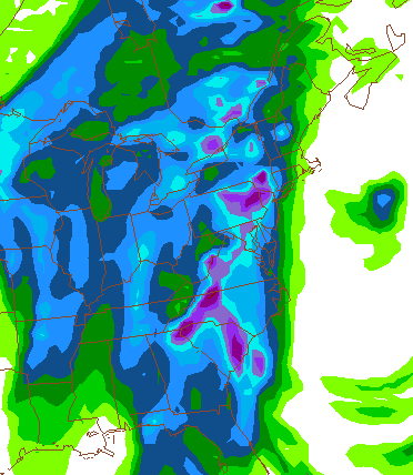
By Tuesday, a cold front is once again knocking on our doorstep. Rain showers and possibly a few thunderstorms will once again work there way into the forecast. A significant rainfall event appears possible Tuesday as the cold front begins to press its way into the metro region. The image at right (morning run of the NAM's precipitation totals) suggests a widespread .75-1.5" rainfall event before the frontal passage occurs late Tuesday night.
Probability of Precip: 95%
High temp: 62 at National Airport
Wednesday will feature improving weather conditions as weak high pressure noses on into the region from the west. Expect generally clear conditions through the end of the week.
Probability of Precip: 30% in the morning, decreasing to 0% by afternoon
High temp: 54 at National Airport
Extended Outlook
More storms and colder temps on the horizon?
As we continue to work our way towards the Christmas season (and for some, I guess it already is the "Christmas Season") and the official start of Winter, there are some good signs that Old Man Winter will begin his fight back. The NAO, famous for being to dominant mode of winter climate variability in the Eastern US, is forecast to rise sharply over the next week or so (bad for cold weather), and then dip down towards negative during the middle of December (good for cold/winter weather).
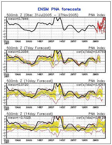 Subsequently, the Pacific North Atlantic (PNA) oscillation is forecast to ramp up towards a highly positive phase (good for cold weather in the east) towards the early/mid parts of December. The image at right are ensemble model forecasts for the PNA index--the red lines are the various ensemble member forecasts for the index. Again, above the zero line is usually a good indicator of a trough in the Eastern United States (cold weather).
**** **** *** ****
Furthermore, the latest runs of the Mid-range star child model, the ECMWF, continues to indicate the possibility that a large Polar Vortex (area of very low atmospheric heights, hence, very low surface temperatures) envelopes Eastern Canada, northwest of the Gulf of Saint Lawrence by December 7.
 The image to the left is the DAY 10 ECMWF forecast at 500 mb (15k-20k feet up) valid December 7. While I don't necessarily agree with this models interpretation of the general pattern in early December, the aforemnetioned indices--PNA, NAO--would both favor a pattern similar to something like this.
 I guess this is what I'm trying to say: colder air looks like it will begin an invasion of the Continental United States once again in the next few weeks. If we can get some Canadian Energy to dive down and generate a nice little low along the east coast, we'll be in business.
Snow lovers just need to wait a few more weeks--WINTER IS JUST AROUND THE CORNER.
Image Credits:
(1) NAM Forecast precip from NCEP
(2) PNA index forecast courtesy of the CPC
(3) ECMWF 10-day forecast courtesy of Plymouth State weather


for this post
Leave a Reply