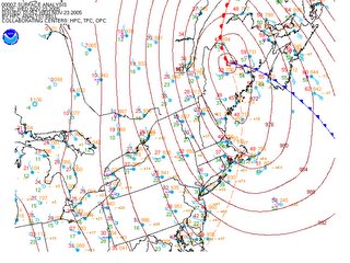
A powerful late November Nor'easter roared to life today along the Eastern Seaboard, battering coastal sections of the Mid Atlantic with 30+ mph winds, heavy rainfall, and snow showers farther inland across interior sections of Pennsylvania and New York. And just as a little food for thought, if this scenario had taken place in the heart of winter, we'd most likely be rejoicing (or repulsing) at the site of a winter wonder land consisting of hills of snow measuring 3 feet deep in some locations.
 Currently, an incredibly intense low pressure system is bombing (intensifying rapidly) in extreme northern Maine, wrapping gusty northwesterly breezes into the Northeast and piling anywhere from 1-9 inches of snow in the mountainous regions of upstate NY, Vermont and New Hampshire.
Surface Analysis courtesy of NCEP/HPC/NWS
Outlook:
By tomorrow morning, winds will have subsided into the 5-15 mph range as the low pressure system continues its track towards the northeast. A mini surface high/ridge builds into the region during the afternoon Wednesday, however, even under partly cloudy skies, temperatures will fail to make it into the upper 40s, and will more than likely be confined to the lower end of the 40s, and it wouldn't surprise me to see some upper 30 degree readings in northern MD.
Clipper-thoughts For Turkey Day:
There is chatter going around that a clipper will make its way into the region Wednesday night-and possibly lay down a coating of the white stuff for Thanksgiving. However, surface temperatures look far too warm to support any snowfall accumulation in the metro region (save the sheltered grassy areas). Folks living out in Western MD and the Appalachian mountains may see snowfall accumulations approaching 3 inches.
As is often the case with clippers, they are not connected to any large moisture source, and come through the region bearing little in the way of gifts for the Mid Atlantic, and this is no exception. The Appalachian Mountains should provide a large obstacle for the snow showers to maneuver around, and a majority of the precipitation will be confined to the western slopes of the Mountains.
Still, late Wednesday night we can expect a 40-60 percent chance of a few light snow flurries/showers across the immediate metro region, but with little in the way of accumulation.
Longer Range:
As this clipper low pulls away Thursday afternoon, colder air will once again be drawn southward into the region, and high temperatures should plummet back into the 30s by this weekend.
Tropical Weather:
The NHC is still closely monitoring an area of thunderstorms about 1000 miles southwest of the Azores way out in the eastern Atlantic. If this system develops into a Tropical Storm its name would be DELTA. Here is a snippet from their daily Tropical Weather Outlook:
 Currently, an incredibly intense low pressure system is bombing (intensifying rapidly) in extreme northern Maine, wrapping gusty northwesterly breezes into the Northeast and piling anywhere from 1-9 inches of snow in the mountainous regions of upstate NY, Vermont and New Hampshire.
 Surface Analysis courtesy of NCEP/HPC/NWS
Outlook:
By tomorrow morning, winds will have subsided into the 5-15 mph range as the low pressure system continues its track towards the northeast. A mini surface high/ridge builds into the region during the afternoon Wednesday, however, even under partly cloudy skies, temperatures will fail to make it into the upper 40s, and will more than likely be confined to the lower end of the 40s, and it wouldn't surprise me to see some upper 30 degree readings in northern MD.
Clipper-thoughts For Turkey Day:
There is chatter going around that a clipper will make its way into the region Wednesday night-and possibly lay down a coating of the white stuff for Thanksgiving. However, surface temperatures look far too warm to support any snowfall accumulation in the metro region (save the sheltered grassy areas). Folks living out in Western MD and the Appalachian mountains may see snowfall accumulations approaching 3 inches.
As is often the case with clippers, they are not connected to any large moisture source, and come through the region bearing little in the way of gifts for the Mid Atlantic, and this is no exception. The Appalachian Mountains should provide a large obstacle for the snow showers to maneuver around, and a majority of the precipitation will be confined to the western slopes of the Mountains.
Still, late Wednesday night we can expect a 40-60 percent chance of a few light snow flurries/showers across the immediate metro region, but with little in the way of accumulation.
Longer Range:
As this clipper low pulls away Thursday afternoon, colder air will once again be drawn southward into the region, and high temperatures should plummet back into the 30s by this weekend.
Tropical Weather:
The NHC is still closely monitoring an area of thunderstorms about 1000 miles southwest of the Azores way out in the eastern Atlantic. If this system develops into a Tropical Storm its name would be DELTA. Here is a snippet from their daily Tropical Weather Outlook:
A STRONG AND LARGE NON-TROPICAL LOW PRESSURE SYSTEM OVER THE CENTRAL ATLANTIC CENTERED ABOUT 1000 MILES SOUTHWEST OF THE AZORES ISLANDS IS DRIFTING SOUTHWARD. THIS SYSTEM IS GRADUALLY ACQUIRING TROPICAL CHARACTERISTICS AND COULD BECOME A TROPICAL STORM AT ANY TIME.


for this post
Leave a Reply