After an early morning low of 37 degrees, the temperatures today couldn't muster enough energy to eclipse the 45 degree mark set overnight. At 1201 AM last night, Reagan National Airport recorded the highest temperature valid for Thursday, November 17th of 45 degrees. Temperatures during the afternoon today never made it above 42 degrees, and have already fallen off into the upper 30s as of 6PM.
Outlook:
Without a doubt, this will be the coldest night of the season as cold, Canadian high pressure slides over the area. Winds will slacken overnight, and allow temperatures to plummet into the 20s across most of the region. Areas of western Maryland will likely fall to around 20 degrees under mainly clear skies.
A nd for those of you who love the warm weather, you may have to move down south a ways for the next couple weeks as highs meander in the upper 40s/near 50. A persistent upper level trough and associated southward bend in the jetstream will remain situated over the region for the next couple weeks at least.
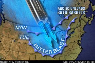
Over the past several months-as alluded to in previous posts-Northwestern Canada has been stocking up massive amounts of cold air, and there are some temperature readings below -20F around Victoria Island and the Beaufort Sea in extreme northwestern Canada. This graphic provided by Accuweather pretty accurately sums up what is occurring-with interest spent on what happens next week to temperatures.
One strong cold front rolled through here yesterday, dropping our temperatures by a good 15-25 degrees. However, the bitter cold is already regrouping in the Arctic, readying for another massive invasion into the Continental United States next week. There is uncertainty as to how "massive" this new wave of cold air is, but early indications are that high temperatures may have a hard time even getting out of the low-mid 40s next Wednesday/Thursday.
Going by the GFS models interpretation of the weather data, highs next week would be sitting in the 30s. This is however, based off of the afternoon 18z run of the model, which occurrs in between the 12z and 00z launch of weather balloons to sample weather data. So, I generally try to steer clear of the 18z and 06z model forecasts when possible.
Some of the white stuff next week?
Early next week, a low pressure system (well offshore) moves northeast into the Grand Banks/Canadian Maritimes. In it's wake along the east coast is a weak surface low that will likely begin a track northeast towards eastern Canada by Thursday. The location of this system with respect to the east coast is uncertain, and will ultimately play a large role in if we get any precipitation at all.
Whatever the case is, this will not be a 3"+ snow event for the region, rather, a few flakes will be possible here and there, possibly mixed with some cold rain. Chances of any precip are small at this point, given model uncertainty and the extended timeframe.
Outlook:
Without a doubt, this will be the coldest night of the season as cold, Canadian high pressure slides over the area. Winds will slacken overnight, and allow temperatures to plummet into the 20s across most of the region. Areas of western Maryland will likely fall to around 20 degrees under mainly clear skies.
A
 nd for those of you who love the warm weather, you may have to move down south a ways for the next couple weeks as highs meander in the upper 40s/near 50. A persistent upper level trough and associated southward bend in the jetstream will remain situated over the region for the next couple weeks at least.
Over the past several months-as alluded to in previous posts-Northwestern Canada has been stocking up massive amounts of cold air, and there are some temperature readings below -20F around Victoria Island and the Beaufort Sea in extreme northwestern Canada. This graphic provided by Accuweather pretty accurately sums up what is occurring-with interest spent on what happens next week to temperatures.
One strong cold front rolled through here yesterday, dropping our temperatures by a good 15-25 degrees. However, the bitter cold is already regrouping in the Arctic, readying for another massive invasion into the Continental United States next week. There is uncertainty as to how "massive" this new wave of cold air is, but early indications are that high temperatures may have a hard time even getting out of the low-mid 40s next Wednesday/Thursday.
Going by the GFS models interpretation of the weather data, highs next week would be sitting in the 30s. This is however, based off of the afternoon 18z run of the model, which occurrs in between the 12z and 00z launch of weather balloons to sample weather data. So, I generally try to steer clear of the 18z and 06z model forecasts when possible.
Some of the white stuff next week?
Early next week, a low pressure system (well offshore) moves northeast into the Grand Banks/Canadian Maritimes. In it's wake along the east coast is a weak surface low that will likely begin a track northeast towards eastern Canada by Thursday. The location of this system with respect to the east coast is uncertain, and will ultimately play a large role in if we get any precipitation at all.
Whatever the case is, this will not be a 3"+ snow event for the region, rather, a few flakes will be possible here and there, possibly mixed with some cold rain. Chances of any precip are small at this point, given model uncertainty and the extended timeframe.


for this post
Leave a Reply