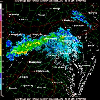
 A bit of a hiccup tonight that has come as a bit of a surprise. I was not anticipating clouds and showers moving into the region this early, but a narrow swath of rain showers extending from North Central MD through central WV continues to move southeastward in association with a mid level feature rotating through the region.
Tonight:
As this vigorous swath of rain showers and a few embedded thunderstorms continues its track towards the DC metro, a steadily increasing chance for precip will develop through the next couple of hours. Granted, the best chance for any significant precipitation will remain north and west of the immediate metro region given the proximity to better forcing and upper level dynamics (more moisture, spin, or "vorticity" in the atmosphere).
Image above: Vigorous line of showers/embedded thunderstorms moving southeast towards the District. Courtesy of the NWS
Tomorrow:
As this first system pulls away, another one enters the stage in the form of a cold front late in the afternoon/evening. A chance for showers will linger through much of the morning, but will increase significantly closer to sunset as a low pressure system makes its move on the area. Still, the bulk of the moisture (similar to the last system-but with different dynamics) will remain north of the region and west of the mountains.
Thursday:
The cold front races through the region by daybreak Thursday, ushering in somewhat cooler temperatures as highs may not be able to break 60 Thursday afternoon.
Winds: As the front pulls away, the combination of a high pressure cell to the southwest, and a strengthening low to the northeast will combine to form some blustery conditions across the region both Thursday and Friday. Winds Thursday will likely be gusting past 30 mph during the afternoon.
Temperatures begin to moderate again as a midlevel ridge moves into the area. Highs Saturday will once again approach the mid 60s, and may once again approach 70 on Sunday.
Thunderstorms: The SPC has our area outlined for a slight risk of severe thunderstorms tomorrow, although the approaching trough/cold front lacks much in the way of a strong thermodynamic set-up (i.e. low level CAPE/Instability, warm low level temps, etc.) Most of the heafty instability is progged to remain south of the region during the day, and slowly migrate eastward by nightfall. From 5-10 pm it's not unlikely a few thunderstorms bubble up with the approach of the cold front, but should mainly be on the weak end of the spectrum.


for this post
Leave a Reply