 Some hints of thanksgiving linger here as turkey leftovers and mashed potatoes still sit in the fridge, while a little more than just a hint of January cold has set in across the region outside.
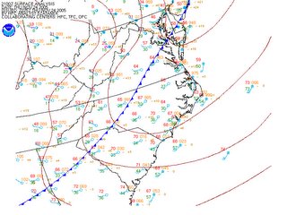
A few hours ago a very intense arctic front crossed the Mid Atlantic, and continues to progress eastward towards lower southern Maryland and the Southeast Coast.
Winds have ramped up significantly around the area, with most observation stations reporting wind gusts in the 30mph range, and as air temperatures drop off into the upper teens and lower 20s, wind chills will approach there coldest values of the season later tonight.
If you plan to venture out later this evening, plan on wearing a couple heavy layers and make sure to button up. By morning tomorrow, surface winds will have slackened somewhat as a weak overnight inversion sets up (increase in air temperature with height until about 1kft above the ground, as opposed to the normal decrease with height), but should not inhibit overnight wind chills to plummet into the single digits out west, and mid teens closer to home.
Don't fret, a Warm-up is Near:
I'm sure this title will get the snow lovers writhing in pain, but we have to remember, it still isn't winter. It seems that we snow fanatics get more spoiled every year, hoping for snow on earlier and earlier occasions; and the snowfall last night either got you salivating for more, or praying for a 70 degree stretch of weather. By this Sunday, the trough in the East will have eroded, handing the stage over to a developing ridge (kind of a high pressure system in the upper levels of the atmosphere), which should begin funneling much warmer temperatures into the region.
 High temperatures through the middle of next week will return to "normal" levels (and then some) topping out in the upper 50s and mid 60s. I am tempted to say temperatures may rocket towards 70 early in the week, but a developing low in the Midwest might hamper these prospects somewhat.
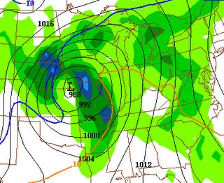
This surface cyclone (which could turn into a good sized winter storm for the Upper Midwest) will throw clouds and showers in our direction late Monday and into Tuesday.
At this point in time, it appears that by Tuesday afternoon, we have popped into the warm sector, south of a progressive warm front, and this should beef temperatures into the low-mid 60s. Depending on the amount of instability that can develop through solar radiation (breaks in the cloud deck) we may have a shot at some thunderstorms Tuesday afternoon and evening, before another cold front whips through the area.
Image (1): HPC Surface analysis earlier this evening showing a powerful cold front racing through the region
Image (2): GFS model prog valid late early Monday morning with a deepening low in the Midwest. Courtesy of NCEP.


for this post
Leave a Reply