Tonight, as winds relax and the sun sets, temperatures will begin to fall into the lower 50s, and eventually bottoming out in the lower 40s by dawn tomorrow.
NBC4 City Cam-Courtesy of NBC weather
Outlook:
Over the next day or two, we will be under the influence of a generally zonal flow, or a flow of the jet stream that aligns itself in a west to east fashion over the Continguous United States. This type of pattern generally favors mild temperatures in our region and very little in the way of 'interesting' weather. With this type of pattern, any 'cool' air induced by a frontal passage is short lived as midlevel ridges build back into the region shortly after the frontal passage.
Wednesday through Veteran's Day
During the midweek, an upper level trough amplifies (strengthens) and digs southeastward into the Mid Atlantic. This results in another cold frontal passage associated with a low in eastern Canada late Wednesday/Thursday morning. High temperatures Wednesday will be in the upper 60s, but will cool down into the mid 50s for Thursday and Veteran's Day.
Saturday and Sunday
However, as explained before, the cooler temperatures are short-lived as high pressure once again builds back into the area, inducing temperature modification by Saturday and Sunday as highs once again climb into the mid/upper 60s.
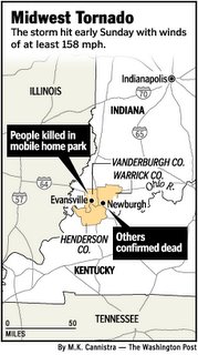
Time permitting, I will be able to make a longer range forecast (into mid/late November) sometime later this week. Tornado in Indiana
As the title of a recent article published by the Washington Post reads: "Everything people Worked for Is Gone," indeed, houses, businesses, and lives have been shattered by a 30 second blast of 160 mph wind concocted by Mother Nature. A quote from the above article reads:
"It's terrible, man. I'm heartbroken," said McDonald, who arrived with a crew from Zion, Ky. "Everything people worked for is gone. Lives are gone. Children. This ain't even my community and I felt like crying all the way back to the street."
These scenes of devastation coming out of Indiana and Kentucky are a poignant reminder of the awesome fury that weather can unleash on any individual.
Image right courtesy of Washington Post


for this post
Leave a Reply