Showers and embedded thunderstorms continue to consolidate and intensify as a cold front nears the area. You will need to keep the umbrella handy if you plan to venture outdoors later this evening.
What we have here are some confused weather Models:
 With all the chatter of the potential for some wintry-type precip invading the region next week, I thought this would be a good time for me to clear a few things up. First, the GFS, which is probably the most commonly employed computer model for mid-term forecast guidance, continues to have severe run to run continuity problems reflected in its forecasts between 1130 and 150 hours out. The image at right (clickable to see larger image) is a mosaic of three separate runs of the GFS, all valid at the same time-Monday November 5th at 18z (1PM EST). The run on the far left is from 00z (last night) 06z (late last night), and 12z (this morning). Notice the position of the low pressure system during Monday afternoon--the low shifts its position by 200-400 miles between computer model runs!
Keeping it short and sweet: the GFS is having a very difficult time with the upcoming weather pattern. It has been having incredibly "mood swings" if you will, and until this model can get its act together, it is probably wise to follow the more consistent European and Canadian Models.
 Now onto the more pressing matter of: Will I get snow?
At this point, there appear to be two separate storm systems that will effect the region next week. The first is what we call an "overrunning event" as a "zipper low" develops along a stalled out frontal boundary to the south of DC during the day Sunday. At this point, temperatures during the event appear very marginal to support snow showers, and precip should fall predominantly as a cold rain. However, there is the potential (albeit quite small) for areas north of DC to squeeze out a few flakes from this system.
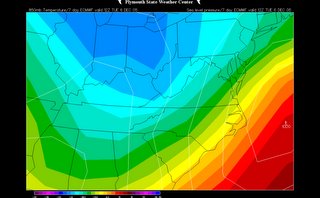
The next system to effect the region follows quickly on the heels of this overrunning system Monday evening/Tuesday. This may end up turning into a sizeable event, although precip type becomes a major problem as this event is nearly 6 days out. The image above is the European Model forecast Tuesday morning of the surface pressure (white lines) and temperatures about 2,000 feet up (shaded colors-greenish yellow is approximate freezing line). This type of set-up would favor a significant snow event for the metro region Monday night and Tuesday morning given the presence of a coastal low and favorable low level temperatures.
Still, this event is lightyears away, and I can recall many a time when the European Model busted what appeared to be a perfectly viable forecast (not saying the one depicted above is a perfectly viable forecast). This is just something to watch. We have over 120 hours separating us from these events, and plenty of time to pin down developing features and forecast details.
Stay Tuned!


for this post
Leave a Reply