 Synopsis:
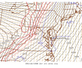
Currently, a vigorous cold front is analyzed near western MD, southwest towards extreme western Tennessee. The image at right is from the Storm Prediction Centers experimental mesoscale analysis page-notice the thin red line near the said regions, and the dashed blue line to the east. These isopleths (called isallobars or lines of equal pressure change) clearly identify the location of this intense frontal system, right along to thin red line running southwest to northeast into central PA.
Outlook:
Clouds are thinning east of the front, allowing surface temperatures to rise into the lower 70s under a tongue of moist, tropical air. Showers are breaking out across portions of north central MD, north Western VA and WV at this time. There are reports of winds gusting to near 40 mph in these showers, and continue to expect gusty winds through the day.
As for thunderstorms--the Sun is currently out across much of eastern MD, destabilizing the atmosphere. I expect isolated cells/lines of convection to bubble up over the next few hours, as the cold front makes its progression towards our area. There is a slight risk of severe thunderstorms across the entire region (east of the cold front) through this afternoon. Winds in thunderstorms have the potential to gust up to 60 mph.
In the higher elevations of the Appalachians, post-frontal precipitation will lag behind as temperatures dip into the lower 30s. Any remaining showers after nightfall will likely turn over the snow or a rain/snow mix.
Temperatures in the general metro region will fall into the upper 30s/lower 40s, and breezy northwest winds of 15-30 mph will make it feel like late December.
Any remaining precipitation will have moved out of the region by Thursday morning.
Extended Chill to the Weather:
Medium range guidance continues to suggest below normal temperatures will dominate the weather over the next week or so. The European model suggests a positively tilted trough (aligned southwest to northeast--opposite of a negatively tilted trough which is aligned southeast to northwest) will remain more or less locked in position along the eastern US.
Temperatures at least through next week/Thanksgiving will remain in the upper 40s/lower 50s.
 After this, a more complex set-up emerges. Forecasters during long-range prognostications utilize what is known as the NAO, or North Atlantic Oscillation-one of the key features in winter weather forecasting, as it almost ALWAYS brings below-normal temperatures to the east. There are two phases to the NAO, a positive and negative. Positive NAO is usually responsible for above normal temperatures and fewer coastal storms, while the negative NAO favors below normal temps and a stormier weather pattern.
I believe that we are headed towards the latter situation. A large ridge is forecast to develop in the north central Atlantic, allowing a deep trough to invade the continental US. How cold it gets depends on the position and intensity of this trough, along with the intensity of the North Atlantic Oscillation.


for this post
Leave a Reply