COMPLEX WEATHER SCENARIO NEXT SEVERAL DAYS
As a low pressure system begins to get organized in the Midwest, a warm frontal boundary will begin to develop in the Ohio River Valley later today/tonight. By midnight, the warm front is knocking on the Nation's Capital, spreading a good chance of rain showers over the region.
As a low pressure system begins to get organized in the Midwest, a warm frontal boundary will begin to develop in the Ohio River Valley later today/tonight. By midnight, the warm front is knocking on the Nation's Capital, spreading a good chance of rain showers over the region.
By Tuesday afternoon, this front has shoved its way north of the region--opening us up to a region known as the warm sector to the east of a cold front, but south of a warm front. Temperatures Tuesday soar into the mid-upper 60s under mostly cloudy conditions.
Don't be surprised to see a few hints of sunshine here and there Tuesday afternoon as a strengthening frontal boundary approaches the region from the west. The real fun stuff gets in here Wednesday morning as the cold front races through the region, opening the door up for much cooler air to migrate southeast into the Mid Atlantic.
Don't be surprised to see a few hints of sunshine here and there Tuesday afternoon as a strengthening frontal boundary approaches the region from the west. The real fun stuff gets in here Wednesday morning as the cold front races through the region, opening the door up for much cooler air to migrate southeast into the Mid Atlantic.
Showers will likely turn over to snow showers in higher elevations of the Appalachians Wednesday night, and lows will fall into the upper 30s closer to the metro region.
High pressure nestles into the area Thursday and beyond, keeping cooler Canadian air locked in place through the weekend. Highs Friday may struggle to make it out of the 40s in many locations-and don't expect high temperatures near 60 any time soon after Wednesday's frontal passage.
 More Tropical Weather?!!
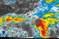
Yeah, that's right, and if you don't believe it-check out the National Hurricane Center's Homepage. Tropical Depression 27 formed earlier this morning--and is expected to become TS-Gamma in the near future.
High pressure nestles into the area Thursday and beyond, keeping cooler Canadian air locked in place through the weekend. Highs Friday may struggle to make it out of the 40s in many locations-and don't expect high temperatures near 60 any time soon after Wednesday's frontal passage.
 More Tropical Weather?!!
Yeah, that's right, and if you don't believe it-check out the National Hurricane Center's Homepage. Tropical Depression 27 formed earlier this morning--and is expected to become TS-Gamma in the near future.
The Hurricane Center develops this system into a hurricane in 4-5 days as it nears Central America. What a wacky Hurricane season this has been (and we still have 15 more days of "official" Hurricane Season left).


for this post
Leave a Reply