SEVERE WEATHER *POSSIBLE* TOMORROW AFTERNOON...COLDER AIR TO INVADE THE MID ATLANTIC
Outlook:
A warm front has just cleared the DC metro region, and continues to press slowly northward with time. Winds have swung around to the south/southwest, drawing a warmer, and more moisture-laden airmass into the area. Through the day, there is a very small chance of precip (less than 30%) as forcing mechanisms (i.e. the cold front/warm front) will remain removed from the region until later tonight. Don't be surprised to see a few breaks in the clouds through the day.
By tomorrow morning, a powerful cold front is situated on the western side of the Appalachians, and POPs (Probability Of Precip) increase to around 50-60%.
Severe weather:
 With the prospect of a vigorous cold front and moist air sliding towards the region, there is a concern that a few severe thunderstorms may bubble up during the afternoon Wednesday. One tool forecasters utilize to predict severe weather/thunderstorms is a thermodynamic profile known as CAPE, or Convective Available Potential Energy), which is measured in Joules/Kg. Generally, values above 2000 J/Kg will support vigorous thunderstorm updrafts, while values below 500 J/Kg or so are not as favorable for convective initiation.
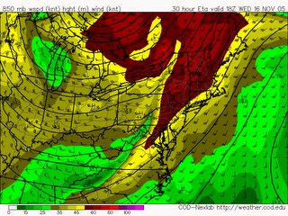
However, given the speed of the low level jet (around 5,000 feet) progged to move over the region tomorrow, CAPE values around 200-400 J/kg, and good moisture content, there is the potential for some severe thunderstorms with damaging wind gusts, and possibly an isolated tornado.
Image Above: 850mb Wind speeds/heights. Red colors indicate very fast wind speeds. Courtesy of College of Dupage Weather
Heavy Rain:
While cold fronts are not generally dubious rain producers, there is a good probability you pick up rainfall amounts from .5-1 inch, and in isolated locations that receive thunderstorm downpours-don't be surprised to find totals near 2 inches.
Wide-spread flooding is not anticipated at this time.
Colder Air invading the region:
Tomorrow's temperature forecast is tricky. The cold front is progged to pass the area between 2PM to 8PM depending on where you live. Temperatures during the morning will likely rise into the mid 50s, but depending on when the front moves through, high temps may range from 55-65.
By Thursday, high temperatures fall into the mid 40s, and stay there into the weekend. Saturday and Sunday will remain below average, with highs in the lower 50s, about 5-10 degrees below average.
And by around Wednesday the 23rd (the day before Thanksgiving), we *may* be in for a little treat of some rain/snow showers in the metro region. Given this forecast is nearly 200 hours away, there is a lot of uncertainty, but the GFS model has been fairly consistent rolling a clipper-like system through the eastern United States during this timeframe, and surface temperatures may be marginally favorable for rain and snow showers...
By tomorrow morning, a powerful cold front is situated on the western side of the Appalachians, and POPs (Probability Of Precip) increase to around 50-60%.
Severe weather:
 With the prospect of a vigorous cold front and moist air sliding towards the region, there is a concern that a few severe thunderstorms may bubble up during the afternoon Wednesday. One tool forecasters utilize to predict severe weather/thunderstorms is a thermodynamic profile known as CAPE, or Convective Available Potential Energy), which is measured in Joules/Kg. Generally, values above 2000 J/Kg will support vigorous thunderstorm updrafts, while values below 500 J/Kg or so are not as favorable for convective initiation.
However, given the speed of the low level jet (around 5,000 feet) progged to move over the region tomorrow, CAPE values around 200-400 J/kg, and good moisture content, there is the potential for some severe thunderstorms with damaging wind gusts, and possibly an isolated tornado.
Image Above: 850mb Wind speeds/heights. Red colors indicate very fast wind speeds. Courtesy of College of Dupage Weather
Heavy Rain:
While cold fronts are not generally dubious rain producers, there is a good probability you pick up rainfall amounts from .5-1 inch, and in isolated locations that receive thunderstorm downpours-don't be surprised to find totals near 2 inches.
Wide-spread flooding is not anticipated at this time.
Colder Air invading the region:
Tomorrow's temperature forecast is tricky. The cold front is progged to pass the area between 2PM to 8PM depending on where you live. Temperatures during the morning will likely rise into the mid 50s, but depending on when the front moves through, high temps may range from 55-65.
By Thursday, high temperatures fall into the mid 40s, and stay there into the weekend. Saturday and Sunday will remain below average, with highs in the lower 50s, about 5-10 degrees below average.
And by around Wednesday the 23rd (the day before Thanksgiving), we *may* be in for a little treat of some rain/snow showers in the metro region. Given this forecast is nearly 200 hours away, there is a lot of uncertainty, but the GFS model has been fairly consistent rolling a clipper-like system through the eastern United States during this timeframe, and surface temperatures may be marginally favorable for rain and snow showers...


for this post
Leave a Reply