 Bone Jarring Cold:
While walking around your house today, be prepared for some shocks while going to open the closet door. Whatever you do, don't go around scuffing up those old shoes on your rugs today...you'll be in for an "electrical" surprise.
Needless to say, dewpoint (and Relative Humidity) values today are the lowest they have been in a long time. Because Relative Humidity (RH from now on) is the measure of how close the air is to saturation, and the Dewpoint is the quantity of moisture in the air, many people get the two terms intertwined. The RH on a partly cloudy day of 70 degrees can be 80 percent, and the air will still feel comfortable. Now take a 60 degree dewpoint and tack it onto that 70 degree day and you've got yourself a good old fashioned sweat-fest.
With that bit of weather information under your belt, the RH outside can be around 30-40 percent on a day when the air temperature is over 100 degrees, and the dewpoint is near 70. With this set-up, the air feels heavy and very muggy, even though humidity values are comparably low.
In today's case, RH values are near 30 percent, and dewpoint values have tumbled from the 30s to below zero in a matter of 12 hours, all thanks to the passage of a ridiculousy powerful arctic cold front.
Today's Outlook:
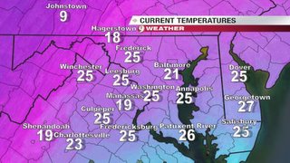
For those of you heading out on this Black Friday for some shopping should be weary of the very cold temperatures. Lows this morning ranged from the mid teens out west, to the lower 20s closer to DC. With winds still gusting to near 15-20 mph, wind chill values (what the air feel like to the skin) are in the single digits and low teens. Be sure to bundle up with extra layers to combat these January like temperatures.
High temperatures today will not make it into the 40s.
Image above right: Temperatures at 900 hour courtesy of WUSA9 Weather
 Dwindiling Delta:
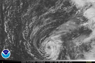
For those of you that didn't know, Tropical storm Delta developed this past Wednesday in the far reaches of the eastern Atlantic Ocean. It seems to upper level shear will once again claim the life of another tropical cyclone in the next 24-48 hours.
Still, maximum sustained winds are around 65 mph, but is of no concern to the Continental US. After Delta becomes extratropical, the wind field should begin to expand as it veers back towards the northwestern African Coastline.
No other tropical development appears imminent at this time.
Image: Visible satellite shot of TS Delta in the eastern Atlantic. Courtesy of the NHC.


for this post
Leave a Reply