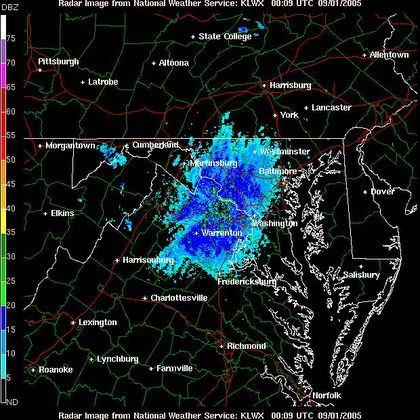
What remains of Katrina has pretty much dissapeared from our picture and is heading up into the northeast and eventually eastern Canada. A few sprinkles remain well west of town in the mountains. Don't worry about any precipitation tonight, just a few scattered clouds here and there.
Radar image a little after 8PM EDT
Tomorrow, weak high pressure builds into the region scouring out a lot of the low level cloudiness and yielding a great day in the Capital. Temperatures should climb into the 80s, but low dewpoints will add a fall-like feel to the air. And this is pretty much the same weather to expect over the next 5 days and beyond.
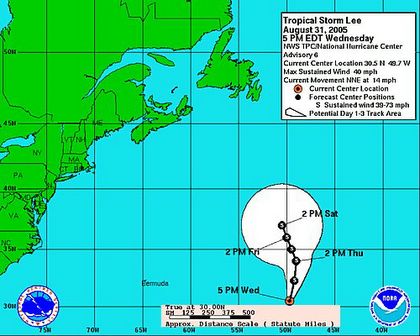
Tropical Storm Lee
Tropical storm Lee, the 12th named storm of this active season formed this afternoon in the central atlantic. This was previously tropical depression 13 which degenerated into a tropical wave a few days ago. Now a tropical storm with winds near 40 mph, Lee is moving harmlessly northward between the Azores and Bermuda.
...TROPICAL STORM LEE...THE 12TH NAMED STORM OF THE SEASON...FORMS
BETWEEN BERMUDA AND THE AZORES...POSES NO THREAT TO LAND...

AT 5 PM AST...2100Z...THE CENTER OF TROPICAL STORM LEE WAS ESTIMATED
NEAR LATITUDE 30.5 NORTH...LONGITUDE  49.7 WEST OR ABOUT 900
MILES...1445 KM...EAST OF BERMUDA AND ABOUT 1390 MILES...2240
KM...WEST-SOUTHWEST OF THE AZORES.

LEE IS MOVING TOWARD THE NORTH-NORTHEAST NEAR 14 MPH...22 KM/HR. A
GRADUAL TURN TO THE NORTH WITH A DECREASE IN FORWARD SPEED IS
EXPECTED DURING THE NEXT 12 TO 24 HOURS.

MAXIMUM SUSTAINED WINDS ARE NEAR  40 MPH... 65 KM/HR...WITH HIGHER
GUSTS. LITTLE CHANGE IN STRENGTH IS FORECAST DURING THE NEXT 24
HOURS.

TROPICAL STORM FORCE WINDS EXTEND OUTWARD UP TO 70 MILES...110 KM
FROM THE CENTER.

ESTIMATED MINIMUM CENTRAL PRESSURE IS 1007 MB...29.74 INCHES.

REPEATING THE 5 PM AST POSITION...30.5 N... 49.7 W.  MOVEMENT
TOWARD...NORTH-NORTHEAST NEAR 14 MPH.  MAXIMUM SUSTAINED WINDS...
40 MPH.  MINIMUM CENTRAL PRESSURE...1007 MB.

THE NEXT ADVISORY WILL BE ISSUED BY THE NATIONAL HURRICANE CENTER AT
11 PM AST.

FORECASTER AVILA
NHC Forecast track for Tropical Storm LEE


for this post
Leave a Reply