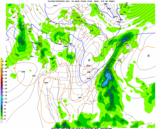
 First off, clouds will continue to thicken overnight as noted on latest visible satellite imagery shots and in response to Tropical Storm Tammy's expanding cloud/rain shield to the southeast. Don't expect any precipitation tonight, just more clouds. The real fun weather moves in Thursday evening/Friday morning as a cold front approaches the region and begins to absorb the remnants of Tammy--pulling them northeast over the eastern seaboard.
It now appears the front will stall at least for a short while Friday night/early Saturday along the eastern shore, allowing several low pressure systems to develop along the front and ride northeast ward into Nova Scotia. This "first round" of rain has the potential to drop a significant amount of rain on the Mid Atlantic region-possibly in excess of 2".
Then there's another concern that yet another tropical low follows suit behind the departing cold front Sunday night/Monday with the chance for even more rain showers, although I am less confident in this part of the forecast.
With all this said, here's quick roundup:
Weather Roundup:
- Clouds increase overnight with a steadily increasing chance of showers through the daytime Thursday
- Best chance of heavy precip moves in late Thursday night/Friday morning
- Gusty winds to 25-35mph possible across the entire region
- Decreasing showers through Saturday, with 20-30% chance of showers Sunday night into Monday
Tropical storm Tammy is expected to move onshore near the Jacksonville area later tonight as a minimal tropical storm with gusty winds and hefty rainfall. On this track, Tammy will move into Georgia Thursday as a tropical depression and then get pulled up to the northeast by the strong cold front discussed above.
for this post
Leave a Reply