
 Snowfall around the region was fairly light with this recent storm. Most locations received between a trace and 2 inches of snow with a thick layer of ice to top it all off. What snow and ice did melt today will refreeze slowly tonight, as temperatures fall only a degree or two below freezing by morning. However, any secondary roads that have not been cleared yet will pose a problem tomorrow morning as ice freezes within tire treads. (I'm currently thinking areas south of DC will not dip below freezing, but just touch the 32 degree mark overnight).
Our attention then turns to a new system developing off the eastern Seaboard during the middle of next week. At this point, most models show a low pressure center forming about 400 to 500 miles off shore, which would limit any precipitation potential around the region. However, I wouldn't rule out the possibility of a few flurries or light snow showers Thursday evening and into early Friday.
Above: Snowfall Map for the January 21-22 storm. Snowfall totals from the National Weather Service in Sterling, VA and Mount Holly, NJ.
Very Cold Airmass to Settle in within two weeks:
The coldest air of this winter season will likely descend upon the region in about 8-10 days as a massive polar vortex rotates southward into the Eastern United States. The image below depicts this scenario:
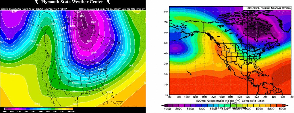
The image on the left is today's 500 mb Geopotential Height from the European Model run valid between the next 7 to 10 days. In other words, the map you see there is the average of the aforementioned model's forecast 500 mb heights for the three day period between the 30th and 1st of February. Notice the massive "blob" of purple and blues covering almost the entire US from coast to coast. This is a region of well below-normal heights, and hence, below normal temperatures. The image on the right is the best correlation I could find for this upcoming weather pattern--January 18th, 2003. The +PNA ridge is evident in both images (the large ridge of high pressure bisected by the west coast) and the Geopotential Heights are nearly identical.
 High Temperatures on that day in Washington were in the 20s, with morning lows in the single digits and low teens, while temperatures in the Northeast only managed to rise into the lower teens for highs.
Finally, the image on the right is the latest GFS (Global Forecast System) Ensemble 850 mb Temperature anomalies valid next Tuesday evening. Notice the large pool of -8 to -12 degree Celcius anomalies engulfing the Eastern United States during this period.
If all goes as currently predicted, the entire eastern half of the United States will see below to well-below normal temperatures in about 8 to 10 days. High temperatures may hover around the lower 20s in the Mid Atlantic.


